| Reference: | S40223 |
| Author | Johannes BLAEU |
| Year: | 1662 ca. |
| Zone: | Vaygach Island |
| Printed: | Amsterdam |
| Measures: | 247 x 170 mm |
| Reference: | S40223 |
| Author | Johannes BLAEU |
| Year: | 1662 ca. |
| Zone: | Vaygach Island |
| Printed: | Amsterdam |
| Measures: | 247 x 170 mm |
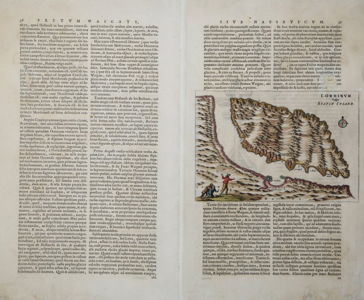
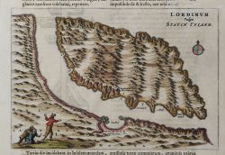
These scarce maps of Vaygach Island (Staten Eyland) were only published in Johannes Blaeu's Atlas Maior.
This map of Staten Eyland is more of a terrestrial map showing numerous mountain ranges and a lake within the island. Several bays are noted along with areas of possible anchorage. In the lower left a scene depicts two Dutch explorers being attacked by a bear. The map is displayed within a page of Latin text, which continues on the verso.
Vaygach Island is an island in the Arctic Sea between the Pechora Sea and the Kara Sea. Vaygach Island is separated from the Yugorsky Peninsula in the mainland by the Yugorsky Strait and from Novaya Zemlya by the Kara Strait.
Johannes BLAEU (Alkmaar 1596 circa - Amsterdam 1663)
|
Joan Blaeu was the eldest son of Willem Janszoon Blaeu (1571-1638), and was probably born in Alkmaar in the province of Noord-Holland in the final years of the 16th century. He was brought up in Amsterdam, and studied law at the University of Leiden before going into partnership with his father in the 1630s. He became chief cartographer to the Dutch East India Company from 1638, and from 1651 to 1672 he served on the Amsterdam City Council without a break, holding several public offices. He also invested in Dutch colonial interests in North America. Joan Blaeu main work was Theatrum Orbis Terrarum (or Atlas Maior as it had became known.) Atlas had expanded to between 9 and 12 volumes, depending on the language. With over 3,000 text pages and approximately 600 maps, it was the most expensive book money could buy in the later 17th century. In 1638 Willem Blaeu died and the business passed into the hands of his sons, Joan and Cornelis, who continued and expanded their father's ambitious plans. After the death of Cornelis, Joan directed the work alone and the whole series of 6 volumes was eventually completed about 1655. As soon as it was finished he began the preparation of the even larger work, the Atlas Major, which reached publication in 1662 in II volumes (later editions in 9-12 volumes) and contained nearly 6oo double-page maps and 3,000 pages of text. This was, and indeed remains, the most magnificent work of its kind ever produced; perhaps its geographical content was not as up-to-date or as accurate as its author could have wished, but any deficiencies in that direction were more than compensated for by the fine engraving and colouring, the elaborate cartouches and pictorial and heraldic detail and especially the splendid calligraphy. In 1672 a disastrous fire destroyed Blaeu's printing house in the Gravenstraat and a year afterwards Joan Blaeu died. The firm's surviving stocks of plates and maps were gradually dispersed, some of the plates being bought by F. de Wit and Schenk and Valck, before final closure in about 1695.
|