| Reference: | s22234 |
| Author | Alexis Hubert JAILLOT |
| Year: | 1706 |
| Zone: | Southern Italy |
| Printed: | Paris |
| Measures: | 615 x 880 mm |
| Reference: | s22234 |
| Author | Alexis Hubert JAILLOT |
| Year: | 1706 |
| Zone: | Southern Italy |
| Printed: | Paris |
| Measures: | 615 x 880 mm |
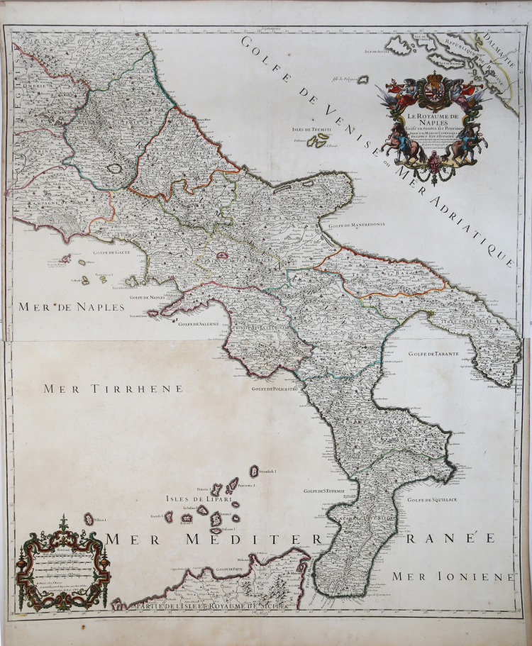
This is Hubert Jaillot's magnificent 1703/06 map of the Kingdom of Naples. Jaillot, along with the rest of the mapmaking establishment, appears to be largely following the model set by Magini nearly a century before; his depiction of the islands of Tremiti suggest that his direct source - as with many of Jaillot's maps - was an Italy map produced by Nicolas Sanson. The present map, however, is engraved on a larger scale, and has superior detail to any Sanson we have handled.
The title and dedicatory cartouche is framed with a sumptuous border. It is surmounted with the dedicatee's arms (Philip V of Spain, and IV of Naples) which is flanked by two trumpet-blowing avatars of fame, shown in conjunction with spears, shields and arrows emphasizing military prowess.
The northern sheet of this map was engraved by Jaillot in 1703 (unjoined examples bear this date in the lower margin of the upper sheet). The lower portion, bearing the date in the scale cartouche, was completed in 1706. Both maps were added to Jaillot's Atlas François, which despite its 1695 dating typically contains numerous maps added later. The map would be re-printed by Covens and Mortier several times in the mid 18th century, and again by Dezauche in 1785.
Alexis Hubert was a skilled businessman born around 1632 in Avignon-lès-Saint-Claude. Since childhood Jaillot had shown a good talent for art and drawing and had learned sculpture from his brother Pierre-Simón. During the Franco-Spanish conflict their hometown was devastated, and so the two brothers moved to Paris in 1657. There they soon acquired a certain reputation and the title of "Sculpteur du Roy". In 1665, Jaillot married with Jeanne Berey, daughter of Nicolas I Berey. Jaillot's fortune was to enter the cartographic market at a particularly favorable time. At the beginning of 1668, under Louis XIV, a particularly fruitful period began for France, as a consequence of the constant territorial expansion there was a great demand for maps that represented French conquests and new frontiers.
Later, Jaillot joined forces with the sons of Nicolas Sanson, and was able to market new maps with the prestigious Sanson name. His Atlas of 1681, the "Atlas Nouveau", became such a commercial success that it was illegally copied by other publishers.
Jaillot cannot be counted among the cartographers of the time such as the Sansons and Duval, but he was a skilled engraver who was able to intelligently exploit the resources he had inherited, making them wonderful works. His fame grew to the point that on 20 July 1686 he was named "Géographe du Roy" and was given a large annual pension; the title allowed him to defend himself against numerous counterfeiters.
A fine example with later hand colour, very good condition.
|
I. Principe "Carte geografiche di Calabria nella raccolta Zerbi", p. 152
|
Alexis Hubert JAILLOT (1632 - 1712)
|
Alexis Hubert Jaillot (c. 1632- 1712) followed Nicholas Sanson (1600 - 1667) and his descendants in ushering in the great age of French Cartography in the late 17th and 18th century. The publishing center of the cartographic world gradually transitioned from Amsterdam to Paris following the disastrous inferno that destroyed the preeminent Blaeu firm in 1672. Hubert Jaillot was born in Franche-Comte and trained as a sculptor. When he married the daughter of the enlumineur de ala Reine, Nicholas Berey, he found himself positioned to inherit a lucrative map and print publishing firm. When Nicholas Sanson, the premier French cartographer of the day, died Jaillot negotiated with his heirs to republish much of Sanson's work. Though not a cartographer himself, Jaillot's access to the Sanson plates enabled him to publish numerous maps and atlases with only slight modifications and updates to the originals. As a sculptor and an artist, Jaillot's maps were particularly admired for their elaborate and meaningful allegorical title cartouches and other decorative elements. Jaillot used his allegorical cartouche work to extol the virtues of the Sun King Louis IV, and his military and political triumphs. These earned him the patronage of the French crown who used his maps in the tutoring of the young Dauphin. In 1686 he was awarded the title of Geographe du Roi< and with it significant prestige and the coveted yearly stipend of 600 Livres. Jaillot was one of the last French map makers to acquire this title. Louis XV, after taking the throne, replaced the position with the more prestigious and singular title of Premier Geographe du Roi. Jaillot died in Paris in 1712. His most important work was his 1693 Le Neptune Francois Jalliot was succeed by his son, Bernard Jean Hyacinthe Jaillot (1673-1739), grandson, Bernard Antoine Jaillot (???? – 1749) and the latter's brother-in-law, Jean Baptiste-Michel Renou de Chauvigné-Jaillot (1710-1780).
|
|
I. Principe "Carte geografiche di Calabria nella raccolta Zerbi", p. 152
|
Alexis Hubert JAILLOT (1632 - 1712)
|
Alexis Hubert Jaillot (c. 1632- 1712) followed Nicholas Sanson (1600 - 1667) and his descendants in ushering in the great age of French Cartography in the late 17th and 18th century. The publishing center of the cartographic world gradually transitioned from Amsterdam to Paris following the disastrous inferno that destroyed the preeminent Blaeu firm in 1672. Hubert Jaillot was born in Franche-Comte and trained as a sculptor. When he married the daughter of the enlumineur de ala Reine, Nicholas Berey, he found himself positioned to inherit a lucrative map and print publishing firm. When Nicholas Sanson, the premier French cartographer of the day, died Jaillot negotiated with his heirs to republish much of Sanson's work. Though not a cartographer himself, Jaillot's access to the Sanson plates enabled him to publish numerous maps and atlases with only slight modifications and updates to the originals. As a sculptor and an artist, Jaillot's maps were particularly admired for their elaborate and meaningful allegorical title cartouches and other decorative elements. Jaillot used his allegorical cartouche work to extol the virtues of the Sun King Louis IV, and his military and political triumphs. These earned him the patronage of the French crown who used his maps in the tutoring of the young Dauphin. In 1686 he was awarded the title of Geographe du Roi< and with it significant prestige and the coveted yearly stipend of 600 Livres. Jaillot was one of the last French map makers to acquire this title. Louis XV, after taking the throne, replaced the position with the more prestigious and singular title of Premier Geographe du Roi. Jaillot died in Paris in 1712. His most important work was his 1693 Le Neptune Francois Jalliot was succeed by his son, Bernard Jean Hyacinthe Jaillot (1673-1739), grandson, Bernard Antoine Jaillot (???? – 1749) and the latter's brother-in-law, Jean Baptiste-Michel Renou de Chauvigné-Jaillot (1710-1780).
|