
| Reference: | CO-353 |
| Author | Charles François DELAMARCHE |
| Year: | 1812 ca. |
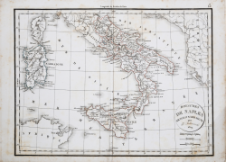
| Zone: | Southern Italy |
| Measures: | 385 x 285 mm |
| Reference: | CO-353 |
| Author | Charles François DELAMARCHE |
| Year: | 1812 ca. |
| Zone: | Southern Italy |
| Measures: | 385 x 285 mm |
Carta del Regno di Napoli pubblicata per la prima volta da Charles François Delamarche nel 1812; esemplare ristampato nel 1829 dal figlio Félix.
Charles François Delamarche (1740 – 1817) è stato un geografo e cartografo francese. Fu uno dei più importanti geografi e cartografi francesi della seconda metà del Settecento. Successore di Nicolas Sanson (1600-1667), Robert de Vaugondy (1686-1766) e Rigobert Bonne (1727-1794), ne ristampò gli atlanti. Si dedicò all'insegnamento della geografia. Tra le sue opere, oltre alle carte e ai globi, va ricordato un trattato sull'uso della sfera, dei globi celesti e dei terrestri (Traité de la sphère et de l'usage des globes, 1790), in cui egli illustra, oltre al sistema tolemaico, anche quello copernicano, enumerando inoltre tutte le costellazioni antiche e moderne.
Suo figlio Félix (XVIII secolo - prima metà XIX secolo) ne continuò l'opera.
Acquaforte, coloritura coeva dei contorni, in buono stato di conservazione.
Charles François DELAMARCHE (1740 – 1817)
|
One of the most important French geographers and mapmakers of the second half of the eighteenth century. Successor to Nicolas Sanson (1600 – 1667), Robert de Vaugondy (1686 – 1766), and Rigobert Bonne (1727 – 1794), whose atlases he reprinted. Also taught geography. In addition to maps and globes, his works include a treatise on the use of the sphere and celestial and terrestrial globes. In the treatise, he illustrates both the Ptolemaic and Copernican systems, as well as listing all the ancient and modern constellations.
|