
| Reference: | CO-352 |
| Author | Gilles Robert de VAUGONDY |
| Year: | 1762 |
| Zone: | Regno di Napoli |
| Printed: | Paris |
| Measures: | 310 x 260 mm |
| Reference: | CO-352 |
| Author | Gilles Robert de VAUGONDY |
| Year: | 1762 |
| Zone: | Regno di Napoli |
| Printed: | Paris |
| Measures: | 310 x 260 mm |
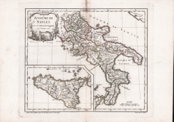
Decorativa carta del Regno di Napoli e della Sicilia, inserita in un riquadro nel Mar Tirreno.
Carta tratta dal Nouvel Atlas Portatif stampato a Parigi nel 1762 che contiene le carte disegnate da Gilles Robert de Vaugondy e suo figlio Didier.
I Robert de Vaugondy furono i cartografi più di successo in Francia durante l'Illuminismo, coprendo un lasso di tempo tra il 1730 ed il 1780; entrambi vennero nominati Géographe ordinaire du Roi, a dimostrazione della massima stima di cui godettero.
Acquaforte, coloritura coeva dei contorni, tracce di colla alla piega centrale, per il resto in ottimo stato di conservazione.
Gilles Robert de VAUGONDY (1688 - 1766)
|
Didier Robert de Vaugondy (1723-1786) was appointed Geographer to Louis XV in 1760. At the same time, de Vaugondy served as Geographer to the Duke of Lorraine and Bar, father-in-law to Louis XV and former King of Poland.
His major contributions to French cartography are the Atlas Universel, 1750-57, The Nouvelle Atlas Portatif (1784) and a very popular map of North America published in 1761. He was son of Gilles Robert de Vaugondy who succeeded Pierre Sanson as the King's Geographer.
|