| Reference: | S35675 |
| Author | Bartolomeo BORGHI |
| Year: | 1845 |
| Zone: | Southern Italy |
| Measures: | 250 x 335 mm |
| Reference: | S35675 |
| Author | Bartolomeo BORGHI |
| Year: | 1845 |
| Zone: | Southern Italy |
| Measures: | 250 x 335 mm |
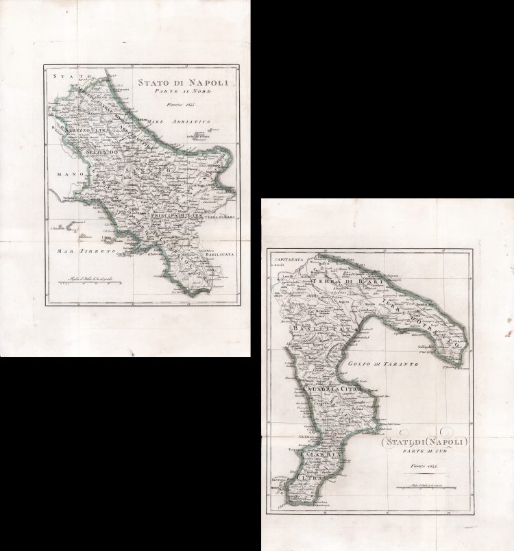
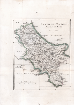
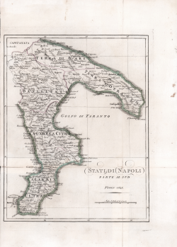
Coppia di carte geografiche di Bartolomeo Borghi, preparata nel 1817 per l'Atlante Geografico dell'abate Bartolomeo Borghi (1750-1821), cartografo, incisore ed editore che tra l'altro pubblicò l'atlante del Pazzini Carli in Siena.
Rara ristampa postuma, con abrasioni nei cartigli con il titolo, stampata a Firenze nel 1845.
Incisione in rame, coloritura coeva dei contorni, in ottimo stato di conservazione
Bartolomeo BORGHI (Monte del Lago 1750 - 1821)
|
Bartolomeo Borghi, who Vermiglioli (Biography o writers Perugini, 1829) calls "one of the best geographers of Europe", was born in 1750 in Monte del Lago, a small fraction of the town of Mansfield, in the province of Perugia, on the shores of Lake Trasimeno. Ordained in 1774, spent the first years of his term in his hometown, then to Mansfield and then Sorbello (Cortona).
A passionate student of geography, first applied his knowledge to the analysis of land more familiar to him: he wrote in 1770 Description geographical, physical and natural Lake Trasimeno (which will however be given to the press for the first time only in 1821), and 1791 published in the Proceedings of Etruscan Cortona a dissertation on the geography of ancient Etruria, Umbria and Piceno, enriching both the works of a map of the regions described. Meanwhile, his fame as a cartographer, as well as a geographer, was growing, so that he get the nomination as a member of the Royal Academies of Florence and Cortona, and give him the job, by Pietro Leopoldo, to outline the paper's public land Cortona and the county of Castiglione.
At the same time the geographical horizons of its activities widened considerably, and if in the Atlas Novissimo, illustrated and amplified the observations and discoveries made by the most recent and most famous cartographer Antonio Zatta (Venice 1779-1785) his contribution was still related area of Tuscany, in the Atlas geographic monthly published in Siena by Pazzini Carli between 1798 and 1800 the villages drew most of the cards and spaced from the provinces of South-East of England, the Kingdom of Denmark, Romania.
A sort of dress rehearsal, the latter, his most important work, quell'Atlante General of AB. Bartolomeo Borghi, published in Florence in 1819. The Atlas, accompanied by brief descriptions of historical, political, civil and natural to introduce the papers relating to the territories belonging to each United Empire or illustrated, reflects the new geo-political structure implemented by the Congress of Vienna.
|