| Reference: | S38306 |
| Author | Abraham ORTELIUS |
| Year: | 1595 ca. |
| Zone: | Southern Italy |
| Printed: | Antwerpen |
| Measures: | 480 x 340 mm |
| Reference: | S38306 |
| Author | Abraham ORTELIUS |
| Year: | 1595 ca. |
| Zone: | Southern Italy |
| Printed: | Antwerpen |
| Measures: | 480 x 340 mm |
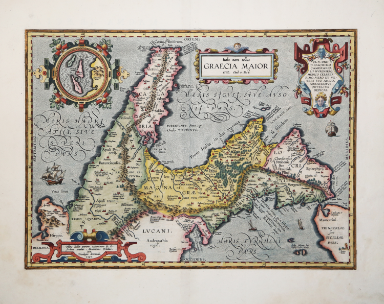
Splendid historical map of Southern Italy, published in Abraham Ortelius' Parergon.
A second state of the plate; after 1595 and before 1601 "Oenotrides insulæ, | quæ Pontia et Iscia" was added at bottom centre, and "Diomedis | campus" was added bottom left.
Title: "Itala nam tellus" | GRAECIA MAIOR | "erat. Ovid. 4 Fast." [Italy, which was once Greater Greece. Ovidius Book 4 "Fastorum"]. At the cartouche bottom left: "Hanc Italiæ partem exteriorem sic de:|scribere conabar Abrahamus Ortelius. | cum | Priuilegio decennali, | 1595". [This exterior part of Italy is thus depicted in the records of Abraham Ortelius with a privilege for ten years, 1595]. Cartouche top right: CL.V.DNO | D. IOACHIMO | CAMERARIO | R.P. NVRENBERG | MEDICO CELEBER:|RIMO, VERO ET VE:|TERI SVO AMICO, | ABRAHAMVS | ORTELIVS | DEDICAB. [Abraham Ortelius has dedicated this map to the most famous lordship Mr. Ioachim Camerarius of Nurnberg, most celebrated physician, as his true and old friend.] Inset, 70 mm diameter, round: Diomedeæ | insulæ. Lower left: "Salapia, | Annibalis me:|ritricio amore |inclytum". [Salapia, well known because of Hannibal's love for a whore].
Lower left: "Aufidus flu. qua solis inter omnes | Italiæ fluvios Apenninum dividit: | teste Polybio". [The river Aufidus, the only river of all Italy, according to Polybius, that divides the Apennine mountain range].
The cartographic sources used by Ortelius are numerous classical authors, specifically Trogus, Plinius, Festus, Servius, Vergilius, Seneca and Strabo. The inset, I. di Tremite [Islands of Tremite] (actually located just outside the lower left corner of the map), belonged to the kingdom of Naples, and are described as the Diomedeæ islands by Plinius, Strabo, Ptolemæus and Festus Stephanus.
The Parergon is the first historical atlas ever published. It was initially conceived by Ortelius as an appendix to his Theatrum Orbis Terrarum but given the considerable success of these historical maps it later became an independent work and remained the main source of all similar works throughout the seventeenth century.
Koeman wrote: “This atlas of ancient geography must be regarded as a personal work of Ortelius. For this work he did not, as in the Theatrum, copy other people's maps but drew the originals himself... He took many places and regions from the lands of classical civilization to illustrate and clarify their history, a subject very close to his heart... The maps and plates of the Parergon have to be evaluated as the most outstanding engravings depicting the wide-spread interest in classical geography in the 16th century."
The Theatrum Orbis Terrarum, which is considered the first true modern "Atlas". The work was published in 7 languages and 36 editions, for which - in 1570 - Ortelius obtained the privilege, a kind of copyright that prevented other cartographers from publishing his works. The Theatrum represented the most advanced work of cartographic description. Ortelius collected in it the geographical and cartographic knowledge of his time, proposing in 147 spectacular engraved plates the most faithful image of the world then known and, in some extraordinary "historical maps", regions and routes taken from literature, mythology, tradition.
Example with contemporary coloring, paper slightly browned, otherwise in excellent condition.
Bibliografia
Cfr. L. Bagrow, A. Ortelli Catalogus Cartographorum; cfr. C. Koeman, Atlantes Neerlandici; Peter H. Meurer, Fontes Cartographici Orteliani 29p; M. Van den Broecke, Ortelius Atlas Maps, n. 210 II/II; Van der Krogt, Koeman’s Atantes Neerlandici: 7400H:31.
Abraham ORTELIUS (1528 - 1598)
|
Abraham Ortel, better known as Ortelius, was born in Antwerp and after studying Greek, Latin and mathematics set up his business there with his sister, as a book dealer and 'painter of maps'. Travelling widely, especially to the great book fairs, his business prospered and he established contacts with many sultured men in many lands. On one such visit to England, possibly seeking temporary refuge from religious persecution, he met William Camden whom he is said to have encouraged in the production of the Britannia.
A turning-point in his career was reached in 1564 with the publication of a World Map in eight sheets of which only one copy is known: other individual maps followed and then - at the suggestion of a friend - he gathered together a collection of maps from contacts among European cartographers and had them engraved in uniform size and issued in 1570 as the Theatrum Orbis Terrarum (Atlas of the Whole World). Although Lafreri and others in Italy had published collections of 'modern' maps in book form in earlier years, the Theatrum was the first uniformly sized, systematic collection of maps and hence can be called the first atlas, although that term itself was not used until twenty years later by Mercator.
The Theatrum, with most of its maps elegantly engraved by Frans Hogenberg, was an instant success and appeared in numerous editions in different languages including addenda issued from time to time incorporating the latest contemporary knowledge and discoveries. The final edition appeared in 1612. Unlike many of his contemporaries Ortelius noted his sources of information and in the first edition acknowledgement was made to eighty-seven different cartographers.
Apart from the modern maps in his major atlas, Ortelius himself compiled a series of historical maps known as the Parergon Theatri which appeared from 1579 onwards, sometimes as a separate publication and sometimes incorporated in the Theatrum.
1570 Theatrum Orbis Terrarum 1570-1612 Between these years the Theatrum was re-issued in 42 editions with 5 supplements with text in Latin, Dutch, German, French, Spanish, Italian and English. The English edition was published in 1606 by John Norton, the maps being printed in Antwerp and the text added in London. Three years later Ortelius died in 1598, his heirs transferred publication rights to Jan Baptiste Vrients who produced the posthumous editions until he died in 1612
1577-85 Spiegel der Werelt (8vo) Maps from the Theatrum, reduced in size, engraved by Philip Galle: text by Pieter Heyns. 6 editions with Dutch, French and Latin text. 1588-i 603 Epitome theatri orbis terrarum (12mo/8v0) 11 further editions of the smaller maps with an increasing number of maps with text also in Italian and English (1603). i6oi-i 2 7 further editions with improved engravings by Arsenius Brothers: text by Michel Coignet in Latin, French, German, Italian and English (1603). 1598-1724 Theatro del Mondo (4t0/12mo/24mo) 8 editions with Italian text; plates engraved in Italy.
1579-1606 Parergon Theatri The number of maps included in the Parergon increased from 4 in 1579 to 43 in 1606 with text in Latin, French, Italian, German and English (1606) 1624 Re-issued in Antwerp as a separate publication by Balthasar Moretus. This edition included a reproduction of the Peutinger table.
|