
| Reference: | MS3208 |
| Author | Georg Woolworth COLTON |
| Year: | 1859 |
| Zone: | Peru |
| Printed: | New York |
| Measures: | 432 x 360 mm |
| Reference: | MS3208 |
| Author | Georg Woolworth COLTON |
| Year: | 1859 |
| Zone: | Peru |
| Printed: | New York |
| Measures: | 432 x 360 mm |
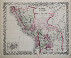
Map taken from Colton's General Atlas, Containing One Hundred And Eighty Steel Plate Maps And Plans, On One Hundred And Nineteen Imperial Folio Sheets, Drawn By G. Woolworth Colton. Letter-Press Descriptions, Geographical, Statistical, And Historical, By Richard Swainson Fisher. New York: G.W. & C.B. Colton, No. 172 William Street. London: Bacon & Co., 48 Paternoster Row. 1866. Entered … 1863, by J.H. Colton … New York. Good conditions.
Detailed map of the region, colored by province and showing towns, rivers, province names and mountains. Bolivia extends to the Pacific Ocean.
Detailed inset of Lima in lower left corner shows street plan.
Georg Woolworth COLTON (1827-1901)
|
Joseph Hutchins Colton, known professionally as J.H. Colton, founded an American mapmaking company which was an international leader in the map publishing industry between 1831 and 1890. In the early 1850s Colton brought his two sons into the business, George Woolworth Colton (1827–1901) and Charles B. Colton (1832–1916).
|