
| Reference: | S46857 |
| Author | Society for the Diffusion of Useful Knowledge |
| Year: | 1838 ca. |
| Zone: | Patagonia |
| Printed: | London |
| Measures: | 410 x 340 mm |
| Reference: | S46857 |
| Author | Society for the Diffusion of Useful Knowledge |
| Year: | 1838 ca. |
| Zone: | Patagonia |
| Printed: | London |
| Measures: | 410 x 340 mm |
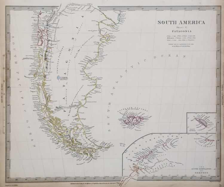
A nice map prepared for the Atlas of the S.D.U.K.
Map of Patagonia or present-day Argentina and Chile, including the Falkland Islands and Tierra del Fuego. Cities, rivers, mountains, lakes and other topographical features are noted. Much of the interior was unexplored at the time. In the interior, which was largely unexplored at the time, several indigenous tribes are identified, including the Chulilau Indians, the Te-huel-het or Southern peoples, and the Puel-che or Eastern peoples. The central region is identified as "inhabited by wandering Indian tribes." Two insets in the lower right quadrant depict South Shetland or Orkney and the Isle of Georgia.
The Society for the Diffusion of Useful Knowledge, or S.D.U.K., as the Society was known, produced inexpensive maps to encourage broad use in education. The maps in these two volumes were issued in parts over several years. The city plans are of particular interest, with vignettes and great detail. Their most important atlas consisted of some 200 separately issued maps, initially published by Baldwin and Cradock and sold by subscription from 1829 to 1844. Later, the Society combined the maps into a single world atlas published under the Chapman and Hall label. At the time, this atlas was unprecedented in quality, scope, and affordability. Today, the Society's maps, or S.D.U.K. as it is commonly called, are among the most impressive examples of mid-nineteenth-century English mass cartographic publishing. S.D.U.K. is best known for its beautiful and accurately detailed city plans.
The first edition being published by Baldwin and Cradock, with the maps issued in numbers and later bound as a set. Engraved by J. & C. Walker. Published by the Society for the Diffusion of Useful Knowledge, 59 Lincolns Inn Fields, Novr. 26th. 1838. (London: Chapman & Hall, 1844).
Steel-engraving with contemporary outline colour, good condition.
Society for the Diffusion of Useful Knowledge (Londra 1826 - 1848)
|
The Society for the Diffusion of Useful Knowledge (1826 - 1848) was a Whiggish organization founded in 1828 on the initiative of English idealist Henry Peter Brougham. The Society's admirable aim was to distribute useful information through a series of publications to the English working and middle classes. It promoted self-education and egalitarian sharing of all knowledge. Although closely associated with the University of London and publishing houses such as Baldwin and Cradock, Chapman and Hall, and Charles Knight, the Society failed to achieve its goals and closed its doors in 1848. Most likely, the failure of the Society was due to the fact that its publications were too expensive for the lower-middle class market for which they were intended, but not large and refined enough to interest the aristocratic market. Nevertheless, the Society managed to publish several extraordinary atlases that were very detailed and sophisticated. Their most important atlas consisted of some 200 separately issued maps, initially published by Baldwin and Cradock and sold by subscription from 1829 to 1844. Later, the Society combined the maps into a single world atlas published under the Chapman and Hall label. At the time, this atlas was unprecedented in quality, scope, and affordability. Today, the Society's maps, or S.D.U.K. as it is commonly called, are among the most impressive examples of mid-nineteenth-century English mass cartographic publishing. S.D.U.K. is best known for its beautiful and accurately detailed city plans.
|