| Reference: | S44866 |
| Author | Johannes de Laet |
| Year: | 1625 ca. |
| Zone: | Brazil |
| Measures: | 360 x 285 mm |
| Reference: | S44866 |
| Author | Johannes de Laet |
| Year: | 1625 ca. |
| Zone: | Brazil |
| Measures: | 360 x 285 mm |
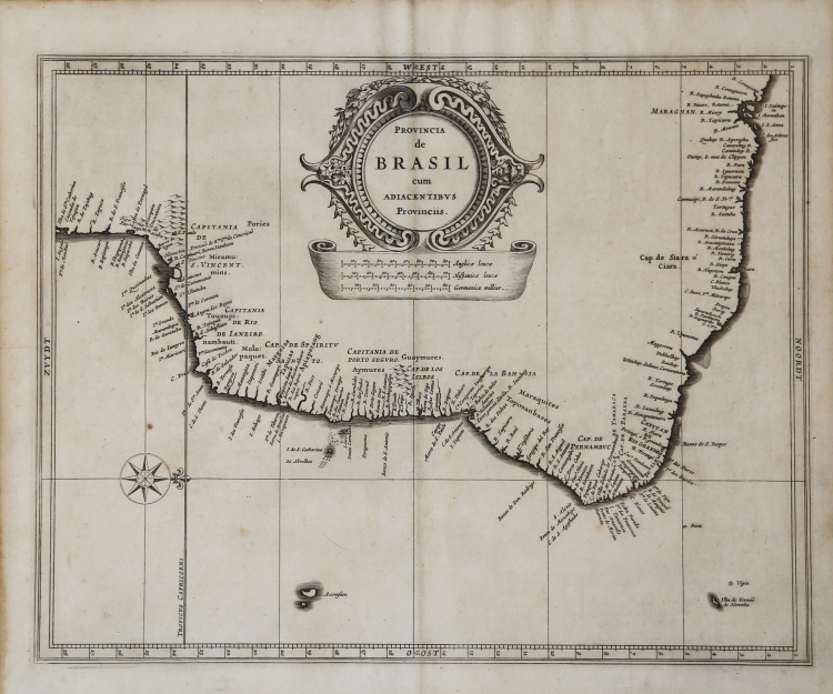
The map covers a large part of present-day Brazil. The map identifies a large number of places along the coast. Interior details have been replaced by a large decorative cartouche and distance scales indicating English, German and Spanish measurements. This variation is indicative of the competing colonial interest in Brazil at the time of publication. The Dutch were particularly interested in acquiring Portuguese sugar plantations, having briefly occupied the city of Salvador in 1624.
This beautiful map is the result of a collaboration between Hessel Gerritsz, official cartographer of the Dutch East India Company, and Johannes de Laet, director of the newly formed Dutch West India Company. Their maps of South America served as a basis for many other cartographers.
De Laet's map appeared in his seminal work on America, which is widely regarded as the most important and influential treatise on the subject published in the 17th Century, the Novus Orbis seu descriptionis Indiae occidentalis Libri XVIII printed in Lugduni Batavorum: Elzevir, 1633.
Third edition of one of the most important of seventeenth-century New World voyages collections, compiled by a director of the recently formed Dutch West India Company, Johannes de Laet (1581-1649). Previous editions were published: the first in Antwerp in Dutch (1625), the second edition-the first in Latin-in Leiden, in 1630, also by the publisher Elzevir.
This issue include for the first time four American regional maps: "Americae sive Indiae Occidentalis", the best West Coast delineation to date, and interestingly depicting California as a peninsula not an island, and stopping short of the controversial region of the North West Passage; "Nova Francia et Regiones Adiacentes", one of the foundation maps of Canada, the first printed map to include an accurate depiction of Prince Edward Island, and the earliest of a north-south oriented Lake Champlain, and still relied upon by Blaeu in 1662 and Coronelli in the 1690s; "Nova Anglia" is of "extreme importance being the first printed one to use the names "Manbattes" (Manhattan), and "N. Amsterdam", or New York, founded in 1626. It is also the earliest to use the Dutch names of "Noordt Rivier" and "Zuyd Rivier", for the Hudson and Delaware Rivers respectively, as well as the Indian "Massachusetts", for the new English colony" (Burden); and "Florida, et regions vicinae" a largely derivative map with one notable alteration in the "placing of "C.Francois" further east into the Atlantic Ocean. Florida, as we know it today, is here called "Tegesta Provinc." This name, applied here for the first time, is that of a tribe of Indians living on the south-west coast. "Florida" was at this time applied to a far larger region" (Burden).
A fine impression, on contemporary laid paper, very good condition.
Johannes de Laet(1581 - 1649
Johannes de Laet(1581 - 1649