| Reference: | S39548 |
| Author | Hendrick de Leth |
| Year: | 1730 ca. |
| Zone: | Southern Africa |
| Printed: | Amsterdam |
| Measures: | 580 x 520 mm |
| Reference: | S39548 |
| Author | Hendrick de Leth |
| Year: | 1730 ca. |
| Zone: | Southern Africa |
| Printed: | Amsterdam |
| Measures: | 580 x 520 mm |
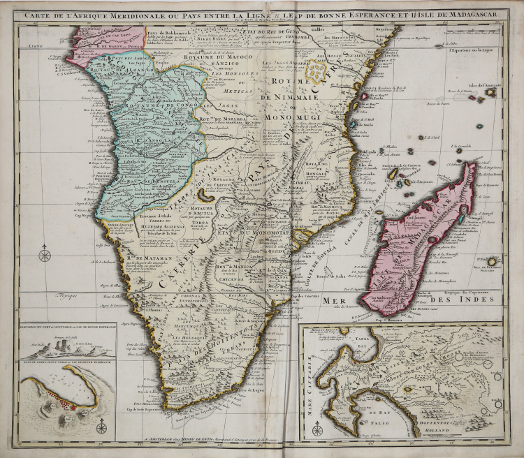
A fine map of Africa south of the Equator including all of Madagascar, with two interesting insets of the Cape of Good Hope.
At left is a plan of Table Bay with an elevation of Table Mountain, and at right is a large plan of the Cape Colony with extensive detail and fairly accurate topographical information including the names of early landowners.
The main part of the map includes the various native kingdoms of the interior and what was known then of the coastline, much of which is fictitious. The cartography is based on Visscher's map of 1710.
Hendrick de Leth (Attivo ad Amsterdam tra il 1703 e il 1766)
|
Printmaker and draughtsman of landscapes, active in Amsterdam.
|
Hendrick de Leth (Attivo ad Amsterdam tra il 1703 e il 1766)
|
Printmaker and draughtsman of landscapes, active in Amsterdam.
|