| Reference: | s34949 |
| Author | Henrick SCHERER |
| Year: | 1702 ca. |
| Zone: | Southern Africa |
| Printed: | Munich |
| Measures: | 354 x 233 mm |
| Reference: | s34949 |
| Author | Henrick SCHERER |
| Year: | 1702 ca. |
| Zone: | Southern Africa |
| Printed: | Munich |
| Measures: | 354 x 233 mm |
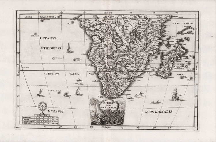
Map of southern Africa, Madagascar, and adjacent islands; is full of the spurious geography of the period with large lakes, rivers and mountains.
The star-like symbol of the Jesuits (IHS) sits atop the distance scale.
The title cartouche depicts two lions, an open chest, and two ormolu plates resting on a table. The map is further adorned with flying fish and sailing ships.
Decorative map Heinrich Scherer for his Atlas Novus exhibens orbem terraguem per naturae opera, historiae navae acveterus monumenta, artistique geographicae leges et praecepta...published in eight volumes from 1702-1710 in Munich. Scherer, a devout Jesuit, produced this geographical compendium to depict the Catholic hierarchy and the spread of Jesuit missions throughout the world.
Copper engraving, in very good condition.
Henrick SCHERER (Dilingen 1628 - Monaco 1704)
|
Heinrich Scherer was a devout Jesuit, and professor of mathematics at Munich. His 'Atlas Novus' contained maps of all other parts which showed the spread of Catholicism and Jesuit missions.
|
Henrick SCHERER (Dilingen 1628 - Monaco 1704)
|
Heinrich Scherer was a devout Jesuit, and professor of mathematics at Munich. His 'Atlas Novus' contained maps of all other parts which showed the spread of Catholicism and Jesuit missions.
|