| Reference: | S42710 |
| Author | Jacques Nicolas BELLIN |
| Year: | 1764 |
| Zone: | Sicily |
| Measures: | 368 x 235 mm |
| Reference: | S42710 |
| Author | Jacques Nicolas BELLIN |
| Year: | 1764 |
| Zone: | Sicily |
| Measures: | 368 x 235 mm |
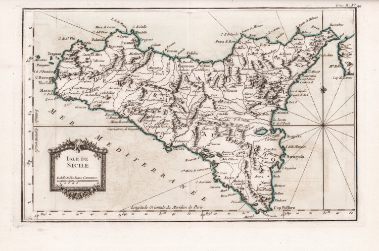
Chart of Sicily from Bellin’s Le Petit Atlas Maritime Recueil De Cartes et Plans Des Quatre Parties Du Monde. en Cinq Volumes. I. Volume. Amerique Septentrionale et Isles Antilles. II. Volume. Amerique Meridionale. Mexique, Terra-Ferme, Bresil, Perou, Chily. III. Volume. Asia et Afrique. IV. Et V. Volumes. Europe et les Etats Qu’elle contient. Par Ordre de M. Le Duc de Choiseul, Colonel General des Suisses et Grisons Ministre de la Guerre et de la Marine. Par le S. Bellin Ingenieur de la Marine 1764.
Nautical chart of small format, without date and signature. From the fourth volume of Le Petit Atlas Maritime, a wonderful small to medium format portolan chart of the entire world, intended more for educational than practical use. Bellin was an important producer of charts for the Depot des cartes et plans de la Marine. The Neptune Francais was published in 1753 and the Hydrographie Francaise in 1756. His largest and most complete work is Le Petit Atlas Maritime, a 5-volume work illustrated with 581 maps, covering the coasts and important port cities of the known world; it is probably the best collection of plans of maritime cities and ports of his time. According to Tooley, Bellin published an earlier version of this atlas in 1763 entitled Petit Atlas Francois. The Duc de Choiseul provided the financial support for the publication that earned him the dedication. Etienne Francois de Choiseul (Nancy, June 28, 1719 - Château de Chanteloup, May 8, 1785) was a French diplomat and politician, former ambassador to Rome and then foreign minister in 1758 during the Seven Years' War. J. Arrivet and listed as an engraver in the index and title pages of the atlas, and it is not ruled out that he may also have engraved the maps.
“Jacques Nicolas Bellin (1703-1772) è stato un importante autore di carte nautiche nel Dépôt de la Marine, del quale divenne direttore pochi anni prima della sua morte. Nel 1753 pubblicò il Neptune François e nel 1756 la Hydrographie Françoise. La sua opera più famosa è il Petit Atlas, in cinque volumi e con oltre 570 carte. Si tratta per lo più di una cartografia di compilazione e sulla scorta del materiale a sua disposizione, come risulta evidente dalla mappa della Sicilia che ricalca modelli figurativi ben più antichi di quelli in circolazione in quegli anni. Il disegno costiero ricorda molto il profilo di Callejo, ma alcuni dettagli interni e di toponomastica sembrano anche rifarsi a Delisle. Solo le coordinate geografiche, le longitudini in particolare, tengono conto delle recenti osservazioni idrografiche francesi nel mare Mediterraneo.
L'incisione è firmata da Jean-Baptiste Croisey, disegnatore e incisore attivo nella seconda metà del XVIII secolo, che lavorò anche all'incisione di alcuni fogli della Carta della Francia di Cassini e per il Dépôt de la Marine.” (Valerio-Spagnolo "Sicilia 1477-1861", p. 471).
Bibliography
National Maritime Museum, Catalogue of the Library - Vol. Three, Atlas & Cartography, London, 1971, pp. 236-238, no. 211; R. Shirley, Maps in the Atlases of the British Library, London, 2004, pp. 1071-1072, M.BELL-5a; Valerio-Spagnolo "Sicilia 1477-1861", pp. 471-472, n. 243.
Jacques Nicolas BELLIN (1703 - 1772)
|
Jacques-Nicolas Bellin (1703 - 1772) was one of the most important cartographers of the 18th century.
With a career spanning some 50 years, Bellin is best understood as transitional mapmaker spanning the gap
between 18th and early 19th century cartographic styles. His long career as Hydrographer and Ingénieur
Hydrographe at the French Dépôt des cartes et plans de la Marine resulted in hundreds of high quality
nautical charts of practically everywhere in the world. Bellin's work focuses on function and accuracy
tending in the process to be less decorative than the earlier 17th and 18th century cartographic work. In
addition to numerous maps and charts published during his lifetime, many of Bellin's maps were updated
(or not) and published posthumously. He was succeeded as Ingénieur Hydrographe by his student, also a prolific and influential cartographer, Rigobert Bonne.
|