
| Reference: | S44275 |
| Author | Eugène Andriveau-Goujon |
| Year: | 1860 |
| Printed: | Paris |
| Measures: | 700 x 530 mm |
| Reference: | S44275 |
| Author | Eugène Andriveau-Goujon |
| Year: | 1860 |
| Printed: | Paris |
| Measures: | 700 x 530 mm |
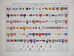
Very decorative originally hand colored chart of flags and rosettes of all sea fearing nations, prepared by J. Andriveau-Goujon and published in his "Atlas Universel". Fantastic double page image, showing the flags of the major countries of the World, including regional, naval, yachting and other flags for the major countries of Europe.
Eugène Andriveau-Goujon (1832 - 1897) was a map publisher and cartographer active in 19th century Paris. The firm was created in 1825 when Eugène Andriveau married the daughter of map publisher Jean Goujon - thus creating Andriveau-Goujon. Maps by Andriveau-Goujon are often confusing to identify as they can be alternately singed J. Goujon, J. Andriveau, J. Andriveau-Goujon, E. Andriveau-Goujon, or simply Andriveau-Goujon. This refers to the multiple generations of the Andriveau-Goujon dynasty and the tendency to republish older material without updating the imprint. The earliest maps to have the Andriveau-Goujon imprint were released by Jean Andriveau-Goujon. He passed the business to his son Gilbert-Gabriel Andriveau-Goujon, who in 1858 passed to his son, Eugène Andriveau-Goujon, under whose management the firm was most prolific. Andriveau-Goujon published numerous fine pocket maps and atlases throughout the 19th century and often worked with other prominent French cartographers of the time such as Brue and Levasseur. The firm's stock was acquired by M. Barrère in 1892.
Litograph with original hand colour, very good condition.
Eugène Andriveau-Goujon (Parigi 1832-1897)
Eugène Andriveau-Goujon (Parigi 1832-1897)