| Reference: | S21841 |
| Author | Giovanni Antonio MAGINI |
| Year: | 1605 ca. |
| Zone: | Sardinia |
| Printed: | Bologna |
| Measures: | 460 x 347 mm |
| Reference: | S21841 |
| Author | Giovanni Antonio MAGINI |
| Year: | 1605 ca. |
| Zone: | Sardinia |
| Printed: | Bologna |
| Measures: | 460 x 347 mm |
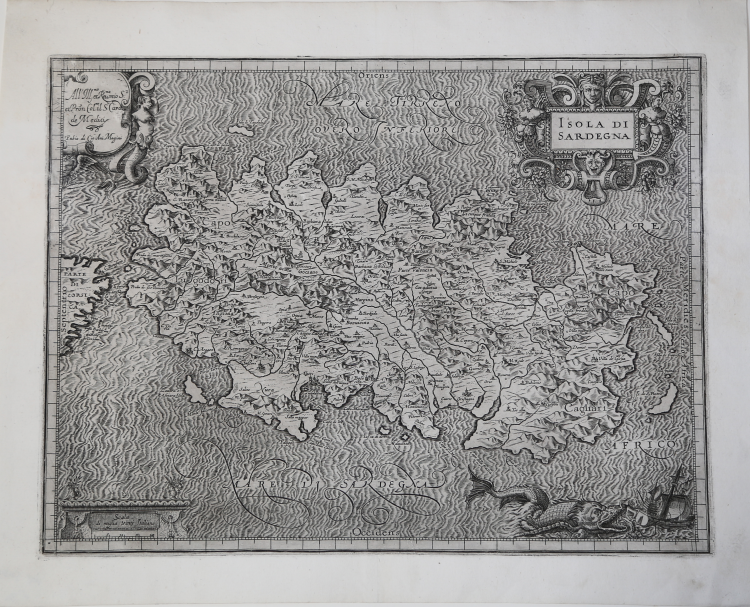
Map taken from L'Italia edited by Fabio Magini, published in Bologna in 1620, three years after the untimely death of his father.
Composed of a short descriptive text of only 24 pages, the work is accompanied by 61 maps of the peninsula, and is the first example of an Italian atlas. The work is entirely by the hand of Giovanni Antonio Magini, who began the realization of the maps in 1594 or so; the first dated map (1595) the map of the territory of Bologna. All the maps were printed before 1620, in their provisional drafts, later corrected and updated for the final edition. For the realization of the plates Magini used two of the most famous engravers of the time: the Belgian Arnoldo Arnoldi and the English Benjamin Wright.
Copperplate, in good condition.
Carta della Sardegna con tre cartigli decorativi e un mostro marino. Realizzata prima del 1605, misura cm 34,3 x 44,5 e, considerando il lato lungo, è in scala di circa 1:736.000, ha i margini graduati ma senza riferimenti numerici e con la suddivisione di 1°, sia per le latitudini sia per le longitudini. Scala di miglia Venti Italiane. L'immagine della Sardegna è tratta da quella disegnata intorno al 1577 dall'ingegnere militare Rocco Cappelino la quale, pur non essendo la migliore in circolazione (soprattutto se confrontata con quella realizzata dal Mercatore), grazie all'avallo datole dal Magini, ebbe un enorme credito e venne diffusa soprattutto dell'editoria francese e olandese.
La carta, gradevolmente decorata, contiene tre bei cartigli: in quello in alto a sinistra è contenuta la dedica al Cardinale Alessandro Ottaviano de' Medici. Il titolo si trova nel cartiglio in alto a destra, ornato con motivi vegetali e figure di mostri, secondo il gusto dell'epoca. In basso a sinistra, in un altro cartiglio è inserita la scala grafica. L'interno della carta è rappresentato come un insieme montuoso, nella quale gruppi di mucchi di talpa sono collocati in maniera del tutto arbitraria. I numerosi fiumi sono tracciati con una doppia linea. Le coste sono caratterizzate da profonde insenature e da ampi golfi. Il mare è reso con un fitto tratteggio ondulato di linee bianche alternate e fasci di linee scure. Nella parte in basso a destra è anche un grande mostro marino in procinto di divorare un veliero. Gruppi di puntini indicano le saline. I centri abitati più importanti sono disegnati con piccole vedute prospettiche a volo d'uccello, gli altri con un cerchietto accompagnati dal relativo toponimo.
In alto, nel cartiglio a destra, il titolo ISOLA DI SARDEGNA; nel cartiglio a sinistra la dedica e l’imprint editoriale All’ Ill.mo et Rev.mo mio S.r et P[at]ron[us] Col.mo il S.r Card. de Medici. Fabio di Gio. Ant. Magino. In basso a sinistra la scala grafica Scala di miglia Venti Italiane (20 miglia pari a mm 40). Orientazione nei quattro lati al centro con il nome dei punti cardinali Septentrio, Meridies, Oriens, Occidens, il nord a sinistra. Graduazione ai margini di 1’ in 1’ ma priva di numerazione.
Incisione in rame, bella impressione tratta dalla prima edizione del 1620, in ottimo stato di conservazione.
Bibliografia
Giovanni Antonio MAGINI (1555 - 1617)
|
Giovanni Antonio Magini was born in Padua in 1555, dedicating himself to the study of astronomy from an early age. In 1588 the Senate of Bologna appointed him Lecturer of Astronomy at the local University, choosing him instead of Galileo Galilei. His friendship with the Duke of Mantua, Vincenzo Gonzaga, helped Magini in his quest to obtain cartographical material for map-making from the various sovereigns ruling the different Italian states at that time. Because of Magini's early death in 1617, this effort was made famous by his son Fabio when he published the atlas "L'Italia" in Bologna in 1620. This is the first example of an Italian atlas and is made up of 24 pages of descriptive text and 61 maps of the Italian peninsula. Although this work was published posthumously, it can be entirely ascribed to Magini. He began drawing this maps around 1594, with the one depicting Bologna and its surrounding territories being the first. They were all printed before 1620 in draft editions which were then revised and updated for the final version. These draft proofs are extremely rare, although sometimes available for sale, and exhibit substantial differences in respect to the maps finally included in the atlas. Two of the most famous engravers of the time, Arnoldo Arnoldi and the englishman Benjamin Wright, were entrusted by Magini to engrave the plates. As we shall see in the presentation of the separate maps, they derive from different sources, both known and unknown, and therefore represent the result of an original work of critical analysis and compilation. This atlas had an important influence on the cartography of the italian peninsula for the following two centuries, beginning from Ortelius and going on to the principal dutch cartographers and editors.
|