| Reference: | A50012 |
| Author | Johannes BLAEU |
| Year: | 1662 ca. |
| Zone: | Sardinia |
| Printed: | Amsterdam |
| Measures: | 500 x 385 mm |
| Reference: | A50012 |
| Author | Johannes BLAEU |
| Year: | 1662 ca. |
| Zone: | Sardinia |
| Printed: | Amsterdam |
| Measures: | 500 x 385 mm |
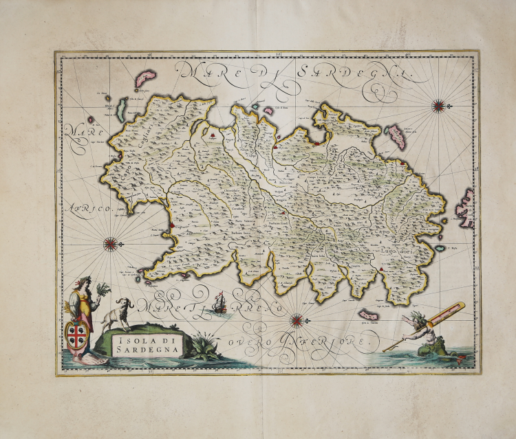
Magnificent map of Sardinia, based on the model of Giovanni Antonio Magini, printed in Amsterdam by Johannes Blaeu and published in his Atlas Maior, sive cosmografphiae Blaviana, qua solum, salum, coelum, accussimae describuntur, Amstelaedami, labore e sumpitubus Joannis Blaeu MDCLXII, composed of eleven volumes.
This splendid map of Sardinia was, therefore, created by Johannes for his “Cosmography”, inserted precisely in the eighth volume entitled "Geographiae Blavianae volumen octavum quo Italia quae est Europae liber decimus sextus continetur". Following its great success, the work was published in various languages for over a decade and contained 593 geographical maps and 3000 pages of text.
The Geographiae Blavianae undoubtedly arose from the development and expansion of the "Theatrum Orbis Terrarum sive Atlas Novus" a work by Johannes' father, the famous cartographer Willem J. Blaeu.
This map depicts three seas, including the "Tyrrhenian Sea," the "Sardinian Sea," and the "African Sea," each with its own 32-way compass rose. In the lower left corner, next to a mouflon, an allegorical figure undoubtedly representing Sardinia holds a sheaf of wheat, an olive branch, and supports the coat of arms of the four Moors resting on a large foot. The Greeks called Sardinia "Sandaliotis" for its foot-like shape, borrowing from the already well-known iconography of Cesare Ripa. The mile scale, at the bottom right, is supported by a sort of sea monster. Although the map undoubtedly derives from that of Giovanni Antonio Magini, this one features, in addition to some improvements in the toponymy, some important corrections, including the exact southern orientation of the Gulf of Cagliari and the correct location of the islands of San Pietro and Sant'Antioco on the southwest coast.
Etching, magnificent contemporary coloring, in excellent condition.
Bibliography
Van der Krogt 2 - 7530:2B; Piloni - Plate XLIII.
Johannes BLAEU (Alkmaar 1596 circa - Amsterdam 1663)
|
Joan Blaeu was the eldest son of Willem Janszoon Blaeu (1571-1638), and was probably born in Alkmaar in the province of Noord-Holland in the final years of the 16th century. He was brought up in Amsterdam, and studied law at the University of Leiden before going into partnership with his father in the 1630s. He became chief cartographer to the Dutch East India Company from 1638, and from 1651 to 1672 he served on the Amsterdam City Council without a break, holding several public offices. He also invested in Dutch colonial interests in North America. Joan Blaeu main work was Theatrum Orbis Terrarum (or Atlas Maior as it had became known.) Atlas had expanded to between 9 and 12 volumes, depending on the language. With over 3,000 text pages and approximately 600 maps, it was the most expensive book money could buy in the later 17th century. In 1638 Willem Blaeu died and the business passed into the hands of his sons, Joan and Cornelis, who continued and expanded their father's ambitious plans. After the death of Cornelis, Joan directed the work alone and the whole series of 6 volumes was eventually completed about 1655. As soon as it was finished he began the preparation of the even larger work, the Atlas Major, which reached publication in 1662 in II volumes (later editions in 9-12 volumes) and contained nearly 6oo double-page maps and 3,000 pages of text. This was, and indeed remains, the most magnificent work of its kind ever produced; perhaps its geographical content was not as up-to-date or as accurate as its author could have wished, but any deficiencies in that direction were more than compensated for by the fine engraving and colouring, the elaborate cartouches and pictorial and heraldic detail and especially the splendid calligraphy. In 1672 a disastrous fire destroyed Blaeu's printing house in the Gravenstraat and a year afterwards Joan Blaeu died. The firm's surviving stocks of plates and maps were gradually dispersed, some of the plates being bought by F. de Wit and Schenk and Valck, before final closure in about 1695.
|