| Reference: | S39463 |
| Author | Georg BRAUN & Franz HOGENBERG |
| Year: | 1588 |
| Zone: | Wroclaw |
| Printed: | Antwerpen & Cologne |
| Measures: | 495 x 380 mm |
| Reference: | S39463 |
| Author | Georg BRAUN & Franz HOGENBERG |
| Year: | 1588 |
| Zone: | Wroclaw |
| Printed: | Antwerpen & Cologne |
| Measures: | 495 x 380 mm |
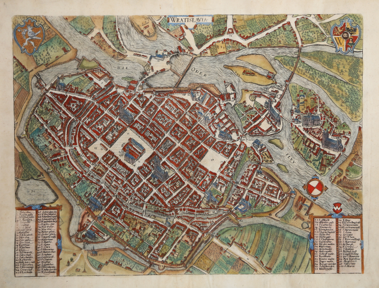
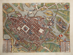
Views of Wratislavia (Wroclaw or Breslau), showing a major town on the Oder River in Lower Silesia. Includes a detailed key showing the location of major points of interest at the lower left and right side of the map, and two decorative coats of arms. Wroclaw (German Breslau) is shown in a bird's-eye view, looking towards southwest, with the River Oder dividing into several arms. Large market squares are at the centre of the fortified city: on the left, the Ring (13) with the town hall (14), next to which is the Salzring (18), and to the right Neumarkt (54).
The work is included in the Civitates Orbis Terrarum, the first atlas devoted exclusively to plans and views of the world's major cities. Printed in six volumes between 1572 and 1617 it was so successful and widespread that several editions translated into Latin, German and French were printed.
The first volume of the Civitates Orbis Terrarum was published in Cologne in 1572. The sixth and the final volume appeared in 1617. This great city atlas, edited by Georg Braun and largely engraved by Franz Hogenberg, eventually contained 546 prospects, bird-eye views and map views of cities from all over the world. Fransz Hogenberg produced the plates for the first four books, and Simon van den Neuwel (Novellanus, active since 1580) those for volumes V and VI.
Georg Braun (1541-1622), a cleric of Cologne, was the principal editor of the work, and was greatly assisted in his project by the close, and continued interest of Abraham Ortelius, whose Theatrum Orbis Terrarum of 1570 was, as a systematic and comprehensive collection of maps of uniform style, the first true atlas. The Civitates, indeed, was intended as a companion for the Theatrum, as indicated by the similarity in the titles and by contemporary references regarding the complementary nature of two works. Nevertheless, the Civitates was designs to be more popular in approach, no doubt because the novelty of a collection of city plans and views represented a more hazardous commercial undertaking than a world atlas, for which there had been a number of successful precedents. Franz Hogenberg (1535-1590) was the son of a Munich engraves who settled in Malines. He engraved most of the plates for Ortelius's Theatrum and the majority of those in the Civitates, and may have been responsible for originating the project.
Over a hundred of different artists and cartographers, the most significant of whom was Antwerp artist Georg Hoefnagel (1542-1600), engraved the cooper-plates of the Civitates from drawings. He not only contributed most of the original material for the Spanish and Italian towns but also reworked and modified those of other contributors. After Hoefnagel's death his son Jakob continued the work for the Civitates.
The author set out to depict "non icones et typi urbium," that is, not generic and typified images, "sed urbes ipsae admirabili caelaturae artificio, spectantium oculis subiectae appareant": not intended to allude or idealize but to represent faithfully on paper, to reproduce exactly, and in real time, what the eye sees, as announced in the preface to the first volume of Civitates Orbis Terrarum.
Etching on copperplate with original hand colour, in good conditions.
|
Van der Krogt 4, #4876; Fauser, #1924; Taschen, Br. Hog., p.322.
|
|
George Braun (1541-1622), cleric of Cologne, was the principal editor of the Civitates Orbis Terrarum, and was greatly assisted in his project by the close, and continued interest of Abraham Ortelius, whose Theatrum Orbis Terrarum of 1570 was, as a systematic and comprehensive collection of maps of uniform style, the first true atlas.
Franz Hogenberg (1535-1590) was the son of a Munich engraves who settled in Malines. He engraved most of the plates for Ortelius's Theatrum and the majority of those in the Civitates, and may have been responsible for originating the project.
|
|
Van der Krogt 4, #4876; Fauser, #1924; Taschen, Br. Hog., p.322.
|
|
George Braun (1541-1622), cleric of Cologne, was the principal editor of the Civitates Orbis Terrarum, and was greatly assisted in his project by the close, and continued interest of Abraham Ortelius, whose Theatrum Orbis Terrarum of 1570 was, as a systematic and comprehensive collection of maps of uniform style, the first true atlas.
Franz Hogenberg (1535-1590) was the son of a Munich engraves who settled in Malines. He engraved most of the plates for Ortelius's Theatrum and the majority of those in the Civitates, and may have been responsible for originating the project.
|