| Reference: | s29393 |
| Author | Giovanni Antonio MAGINI |
| Year: | 1602 ca. |
| Zone: | Piedmont |
| Printed: | Bologna |
| Measures: | 470 x 360 mm |
| Reference: | s29393 |
| Author | Giovanni Antonio MAGINI |
| Year: | 1602 ca. |
| Zone: | Piedmont |
| Printed: | Bologna |
| Measures: | 470 x 360 mm |
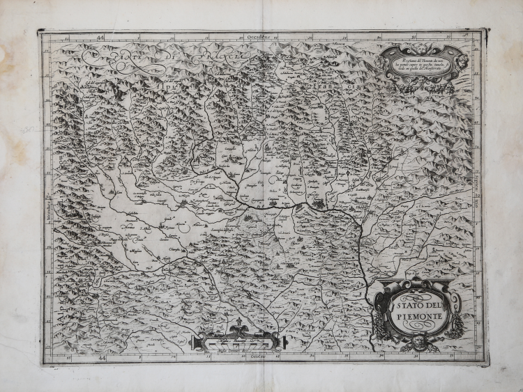
Map taken from L'Italia edited by Fabio Magini, published in Bologna in 1620, three years after the untimely death of his father.
Composed of a short descriptive text of only 24 pages, the work is accompanied by 61 maps of the peninsula, and is the first example of an Italian atlas. The work is entirely by the hand of Giovanni Antonio Magini, who began the realization of the maps in 1594 or so; the first dated map (1595) the map of the territory of Bologna. All the maps were printed before 1620, in their provisional drafts, later corrected and updated for the final edition. For the realization of the plates Magini used two of the most famous engravers of the time: the Belgian Arnoldo Arnoldi and the English Benjamin Wright.
Copperplate, in good condition.
La carta del Piemonte del Magini non presenta grandi somiglianze con le altre carte a stampa antecedenti a questa, nell’ordine: del piccolo Gastaldi nel 1548, del Cock nel 1552, delle due edite dal Lafrery nel 1553 e 1564, del grande Gastaldi nel 1555, del Ruscelli nel 1561, del Forlani nel 1567, del De Jode nel 1578 e del Mercator nel 1589. Una prima stesura venne realizzata dall’autore nel 1597 basandosi su un disegno, eseguito per questioni di confini, procuratogli dal suo amico il Duca di Mantova Vincenzo Gonzaga.
La stesura definitiva della carta venne realizzata nel 1609, basandosi su materiale ricevuto direttamente dal Duca di Savoia.
La carta, proprio per il periodo in cui è realizzata, è quindi intagliata in rame dall’Arnoldi e poi corretta dal Wright.
In basso a destra, nel cartiglio, il titolo STATO DEL PIEMONTE. Al centro le scale grafiche Miglia Piemontesi e Miglia Communi dieci ( 10 miglia pari a mm 60). In alto nel cartiglio a destra una nota Il restante del Piemonte che non ha potuto capire in questa tavola, si vede in quella del Monferrato. Orientazione nei quattro lati al centro con il nome dei punti cardinali Septentrio, Meridies, Oriens, Occidens, il nord a destra. Graduazione ai margini di 1’in 1’ da 43° 52’ 10’’ a 44° 53’ di latitudine, e da 29° 28’ a 30° 31’ 20’’ di longitudine.
Incisione in rame, lieve gora nei margini, nel complesso in ottim
|
R. Almagià, L'"Italia" di Giovanni Antonio Magini…, pp. 25-27; Barrera (1991): p. 28, n. 13.
|
Giovanni Antonio MAGINI (1555 - 1617)
|
Giovanni Antonio Magini was born in Padua in 1555, dedicating himself to the study of astronomy from an early age. In 1588 the Senate of Bologna appointed him Lecturer of Astronomy at the local University, choosing him instead of Galileo Galilei. His friendship with the Duke of Mantua, Vincenzo Gonzaga, helped Magini in his quest to obtain cartographical material for map-making from the various sovereigns ruling the different Italian states at that time. Because of Magini's early death in 1617, this effort was made famous by his son Fabio when he published the atlas "L'Italia" in Bologna in 1620. This is the first example of an Italian atlas and is made up of 24 pages of descriptive text and 61 maps of the Italian peninsula. Although this work was published posthumously, it can be entirely ascribed to Magini. He began drawing this maps around 1594, with the one depicting Bologna and its surrounding territories being the first. They were all printed before 1620 in draft editions which were then revised and updated for the final version. These draft proofs are extremely rare, although sometimes available for sale, and exhibit substantial differences in respect to the maps finally included in the atlas. Two of the most famous engravers of the time, Arnoldo Arnoldi and the englishman Benjamin Wright, were entrusted by Magini to engrave the plates. As we shall see in the presentation of the separate maps, they derive from different sources, both known and unknown, and therefore represent the result of an original work of critical analysis and compilation. This atlas had an important influence on the cartography of the italian peninsula for the following two centuries, beginning from Ortelius and going on to the principal dutch cartographers and editors.
|
|
R. Almagià, L'"Italia" di Giovanni Antonio Magini…, pp. 25-27; Barrera (1991): p. 28, n. 13.
|
Giovanni Antonio MAGINI (1555 - 1617)
|
Giovanni Antonio Magini was born in Padua in 1555, dedicating himself to the study of astronomy from an early age. In 1588 the Senate of Bologna appointed him Lecturer of Astronomy at the local University, choosing him instead of Galileo Galilei. His friendship with the Duke of Mantua, Vincenzo Gonzaga, helped Magini in his quest to obtain cartographical material for map-making from the various sovereigns ruling the different Italian states at that time. Because of Magini's early death in 1617, this effort was made famous by his son Fabio when he published the atlas "L'Italia" in Bologna in 1620. This is the first example of an Italian atlas and is made up of 24 pages of descriptive text and 61 maps of the Italian peninsula. Although this work was published posthumously, it can be entirely ascribed to Magini. He began drawing this maps around 1594, with the one depicting Bologna and its surrounding territories being the first. They were all printed before 1620 in draft editions which were then revised and updated for the final version. These draft proofs are extremely rare, although sometimes available for sale, and exhibit substantial differences in respect to the maps finally included in the atlas. Two of the most famous engravers of the time, Arnoldo Arnoldi and the englishman Benjamin Wright, were entrusted by Magini to engrave the plates. As we shall see in the presentation of the separate maps, they derive from different sources, both known and unknown, and therefore represent the result of an original work of critical analysis and compilation. This atlas had an important influence on the cartography of the italian peninsula for the following two centuries, beginning from Ortelius and going on to the principal dutch cartographers and editors.
|