| Reference: | S48754 |
| Author | Giovanni Antonio MAGINI |
| Year: | 1597 ca. |
| Zone: | Piemonte |
| Printed: | Bologna |
| Measures: | 485 x 385 mm |
| Reference: | S48754 |
| Author | Giovanni Antonio MAGINI |
| Year: | 1597 ca. |
| Zone: | Piemonte |
| Printed: | Bologna |
| Measures: | 485 x 385 mm |
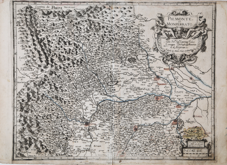
Nel cartiglio in alto a destra il titolo PIEMONTE ET MONFERRATO la dedica Alla Ser.ma Sig.ra Caterina Medici Gonzaga Duchessa di Mantova et di Monferrato etc. Firmata da Fabio di Gio: Antonio Magini padovano. Nel cartiglio in basso a destra si legge: Vedi il restante del Piemonte et Monferrato nella tavola della Liguria da Ponente. Presente la scala grafica Scala di Miglia Quindici (15 miglia pari a mm 58). Orientazione nei quattro lati al centro con il nome dei punti cardinali Septentrio, Meridies, Oriens, Occidens, il nord in alto. Graduazione ai margini di 1’ in 1’ da 28° 45’ 30’’ a 31° 17’ 20’’ di longitudine, e da 44° 2’ 15’’ a 45° 28’ di longitudine.
Esemplare di secondo stato con la dedica di Fabio Magini.
Carta geografica tratta dal L’Italia a cura di Fabio Magini, edito a Bologna nel 1620, tre anni dopo la prematura morte del padre.
Composto da un breve testo descrittivo di sole 24 carte, l’opera è corredata di 61 carte geografiche della penisola, e costituisce il primo esempio di atlante italiano. L’opera è per intero di mano del Magini, che iniziò la realizzazione delle carte nel 1594 circa, dando alla luce per prima nel 1595 la carta del territorio di Bologna. Tutte le carte vennero alle stampe quindi prima del 1620, nelle loro stesure provvisorie, successivamente corrette ed aggiornate per l’edizione definitiva. Per la realizzazione delle lastre il Magini si servì di due dei più famosi intagliatori dell’epoca: il belga Arnoldo Arnoldi e l’inglese Benjamin Wright.
Scrive Roberto Almagià nel suo saggio sull'opera maginiana del 1922: "Le carte del Piemonte e della Liguria in generale debbono essere considerate insieme, perché riposano di materiali comuni. […] per tali carte il Magini ebbe i materiali ed eseguì il lavoro in due epoche diverse ed assai lontane: una prima volta nel 1597 (e forse in parte ancora l'anno prima) e una seconda volta, oltre dieci anni dopo, nel 1608-9. Come risulta anche dall'elenco del 1604, la prima volta egli mise insieme due carte delle due Riviere e tre carte del Piemonte".
Incisione in rame, in ottimo stato di conservazione.
Bibliografia
Almagià, L'Italia di Giovanni Antonio Magini e la Cartografia dell'Italia nei secolo XVI e XVII (1922), pp. 23-29; Barrera (1991): p. 27, n. 12.
Giovanni Antonio MAGINI (1555 - 1617)
|
Giovanni Antonio Magini was born in Padua in 1555, dedicating himself to the study of astronomy from an early age. In 1588 the Senate of Bologna appointed him Lecturer of Astronomy at the local University, choosing him instead of Galileo Galilei. His friendship with the Duke of Mantua, Vincenzo Gonzaga, helped Magini in his quest to obtain cartographical material for map-making from the various sovereigns ruling the different Italian states at that time. Because of Magini's early death in 1617, this effort was made famous by his son Fabio when he published the atlas "L'Italia" in Bologna in 1620. This is the first example of an Italian atlas and is made up of 24 pages of descriptive text and 61 maps of the Italian peninsula. Although this work was published posthumously, it can be entirely ascribed to Magini. He began drawing this maps around 1594, with the one depicting Bologna and its surrounding territories being the first. They were all printed before 1620 in draft editions which were then revised and updated for the final version. These draft proofs are extremely rare, although sometimes available for sale, and exhibit substantial differences in respect to the maps finally included in the atlas. Two of the most famous engravers of the time, Arnoldo Arnoldi and the englishman Benjamin Wright, were entrusted by Magini to engrave the plates. As we shall see in the presentation of the separate maps, they derive from different sources, both known and unknown, and therefore represent the result of an original work of critical analysis and compilation. This atlas had an important influence on the cartography of the italian peninsula for the following two centuries, beginning from Ortelius and going on to the principal dutch cartographers and editors.
|