
| Reference: | S38208 |
| Author | Laurent FRIES |
| Year: | 1525 |
| Zone: | Persia |
| Printed: | Strasbourg |
| Measures: | 410 x 550 mm |
| Reference: | S38208 |
| Author | Laurent FRIES |
| Year: | 1525 |
| Zone: | Persia |
| Printed: | Strasbourg |
| Measures: | 410 x 550 mm |
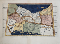
Ptolemaic map of the region between the Persian Gulf and the Caspian Sea showing Babylon and Mesopotamia as well as several ancient religious sites. The base of the Caspian Sea, also named the Hyrcanian Sea, is at the top of the map. Armenia is in the upper left, and the Arabian Desert is named in the lower left. Major mountain ranges, rivers, and cities are shown.
La mappa è basata sulla mappa di Waldseemuller, pubblicata per la prima volta nella Geographia di Strasburgo del 1513.
From Claudii Ptolemaei Alexandrini Geographicae Enarrationis, 1525.
La prima edizione della "Geographia" di Tolomeo curata da Fries fu pubblicata a Strasburgo nel 1522, con le carte che furono copiate e nuovamente incise da quelle di Martin Waldseemüller dell'edizione di Tolomeo del 1520 e testo a cura di Pirckheimer. Nel 1525 viene stampata una seconda edizione a Strasburgo. Alla scomparsa del Fries e del Gruninger, le matrici furono acquistate dai fratelli Melchior e Gaspar Treschel che ne stampano una terza edizione a Lione nel 1535. Per il testo i due editori si servirono della supervisione di Michael Servetus, che curò la revisione del testo del Pirckheimer. Infine, nel 1541, Gaspare Treechsel pubblica a Vienne, nel Delfinato, questa quarta edizione, sempre con testo di Servetus. In questa edizione, rispetto alla prima di Strasburgo del 1522, il testo subì numerose modifiche, correzioni e aggiunte, ma i legni non furono modificati.
Xilografia, finemente colorata a mano, in ottimo stato di conservazione.
|
Lorenz (Laurent) Fries was born in Alsace in about 1490. He studied medicine, apparently spending time at the universities of Pavia, Piacenza, Montpellier and Vienna. After completing his medical studies, , Fries worked as a physician in several places, before settling in Strassburg, in about 1519. In Strassburg, Fries met the Strasbourg printer and publisher Johann Grüninger, an associate of the St. Die group of scholars formed by, among others, Walter Lud, Martin Ringmann and Martin Waldseemuller.From 1520 to 1525, Fries worked with Gruninger as a cartographic editor, exploiting the corpus of material that Waldseemuller had created. Fries' first venture into mapmaking was in 1520, when he executed a reduction of Martin Waldseemuller's wall-map of the World, published in 1507. Next Fries’ project was a new edition of the Geographia of Claudius Ptolemy, which was published by Johann Koberger in 1522. Fries evidently edited the maps, in most cases simply producing a reduction of the equivalent map from Waldseemuller's 1513 edition of the Geographie Opus Novissima, printed by Johann Schott. Fries also prepare three new maps for the Geographie: maps of South-East Asia and the East Indies, China and the World, but the geography of these derives from Waldseemuller's world map of 1507. The 1522 edition of Fries work , now very rare, was not commercially successful. In 1525, an improved edition was issued, from the notes of Johannes Regiomontanus. After Grüninger's death in 1531, the business was continued by his son Christoph, who seems to have sold the materials for the Ptolemy to two Lyon publishers, the brothers Melchior and Gaspar Trechsel, who published a joint edition in 1535, before Gaspar Trechsel published an edition in his own right in 1541.
|
|
Lorenz (Laurent) Fries was born in Alsace in about 1490. He studied medicine, apparently spending time at the universities of Pavia, Piacenza, Montpellier and Vienna. After completing his medical studies, , Fries worked as a physician in several places, before settling in Strassburg, in about 1519. In Strassburg, Fries met the Strasbourg printer and publisher Johann Grüninger, an associate of the St. Die group of scholars formed by, among others, Walter Lud, Martin Ringmann and Martin Waldseemuller.From 1520 to 1525, Fries worked with Gruninger as a cartographic editor, exploiting the corpus of material that Waldseemuller had created. Fries' first venture into mapmaking was in 1520, when he executed a reduction of Martin Waldseemuller's wall-map of the World, published in 1507. Next Fries’ project was a new edition of the Geographia of Claudius Ptolemy, which was published by Johann Koberger in 1522. Fries evidently edited the maps, in most cases simply producing a reduction of the equivalent map from Waldseemuller's 1513 edition of the Geographie Opus Novissima, printed by Johann Schott. Fries also prepare three new maps for the Geographie: maps of South-East Asia and the East Indies, China and the World, but the geography of these derives from Waldseemuller's world map of 1507. The 1522 edition of Fries work , now very rare, was not commercially successful. In 1525, an improved edition was issued, from the notes of Johannes Regiomontanus. After Grüninger's death in 1531, the business was continued by his son Christoph, who seems to have sold the materials for the Ptolemy to two Lyon publishers, the brothers Melchior and Gaspar Trechsel, who published a joint edition in 1535, before Gaspar Trechsel published an edition in his own right in 1541.
|