| Reference: | S46845 |
| Author | Carl Joseph MEYER |
| Year: | 1852 |
| Zone: | Northern Sea |
| Printed: | Hildburghausen |
| Measures: | 265 x 310 mm |
| Reference: | S46845 |
| Author | Carl Joseph MEYER |
| Year: | 1852 |
| Zone: | Northern Sea |
| Printed: | Hildburghausen |
| Measures: | 265 x 310 mm |
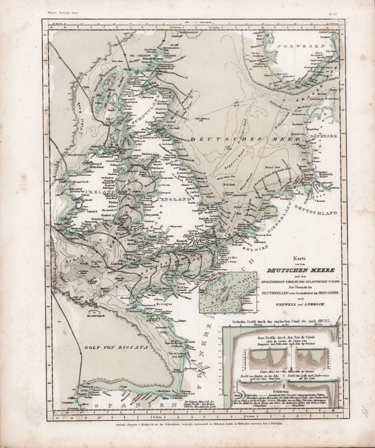
Karte von dem Deutschen Meere und den Angränzenden Theilen Des Atlantischen Oceans, Zur Übersicht der Fluthwellen u. der Beschaffenheit des Seebodens.
Map of the German Sea and the adjoining parts of the Atlantic Ocean, for an overview of the tidal waves and the nature of the seabed.
Taken form Neueste Zeitungs-Atlas für Alte & Neue Erdkunde With a engraved title page, index, and 123 steel engraving outline hand colored maps dated between 1849-1852. These atlas maps were produced in Hildburghausen, Amsterdam, and New York, and are considered some of the most detailed maps produced in the 19th Century. Atlas includes 123 maps of old geography, maps of modern geography, and maps of physical geography. The maps are of the highest Meyer quality, with detail information, showing political and administrative boundaries, cities, towns, canals, forts, roads, railroads, rivers and mountains.
Steel-engraving, contemporary hand-coloring, light foxing, otherwise in very good condition
Carl Joseph MEYER (Gotha, 1796 – Hildburghausen, 1856)
|
Carl Joseph Meyer (9 May 1796 - 27 June 1856) was a German industrialist and publisher, most noted for his encyclopaedia, Meyers Konversations-Lexikon.
Meyer was born at Gotha, Germany, and was educated as a merchant in Frankfurt am Main. He went to London in 1816, but returned to Germany in 1820 after business adventures and stock speculations fell through. Here he invested in enterprises such as the textile trade (1820–24). Soon after the first steam-hauled railway had started in December 1835, Meyer started to make business plans to start the first railways. He also bought some concessions for iron mining. In 1845 he founded the Deutsche Eisenbahnschienen-Compagnie auf Actien (German Railway Rail joint stock company). Meyer operated very successfully as a publisher, employing a system of serial subscription to publications, which was new at that time. To this end he founded a company, Bibliographisches Institut, in Gotha in 1826. It published several editions of the Bible, works of classical literature, the world in pictures on steel engravings ("Meyers Universum", 1833–61, 17 volumes in 12 languages with 80,000 subscribers all over Europe), and an encyclopaedia, ("Das Grosse Conversations-Lexikon für die gebildeten Stände"; see Meyers Konversations-Lexikon, 1839–55, 52 volumes). His company grew substantially, and in 1828 he moved it from Gotha to Hildburghausen. He became involved in cartography, producing many atlases with steel-engraved maps printed from steel plates, including Meyer's Groẞer Hand-Atlas (1843-1860). After Meyer's death in 1856, his son Herrmann Julius Meyer took over the Bibliographisches Institut, which was at that time struggling financially.
|