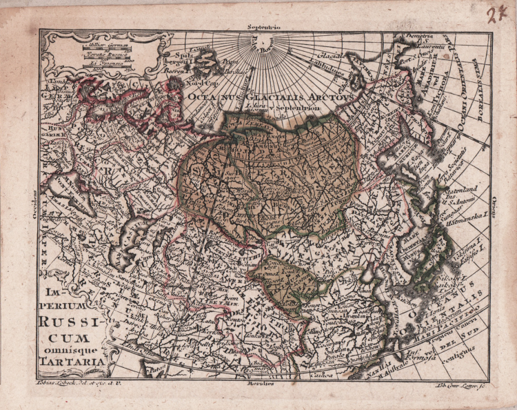
| Reference: | S4429 |
| Author | Tobias Conrad LOTTER |
| Year: | 1762 ca. |
| Zone: | Tartary |
| Printed: | Ausburg |
| Measures: | 127 x 105 mm |
| Reference: | S4429 |
| Author | Tobias Conrad LOTTER |
| Year: | 1762 ca. |
| Zone: | Tartary |
| Printed: | Ausburg |
| Measures: | 127 x 105 mm |
A small map taken from the "Atlas geographicus portabilis XXIX mappis orbis habitabilis regna exibens" by Lobeck.
Rare portable atlas, in contemporary colouring. Of remarkable taste and elegance, the frontispiece and title page, engraved by Tobias Lobeck on Gottfried Eichler's design. The maps are engraved by Tobias Lotter from the drawings of Tobias Lobeck.
Copperplate with original hand colour, refreshed, in good conditions.
Tobias Conrad LOTTER (1717 - 1777)
|
Tobias Conrad Lotter (1717 - 1777) was a German engraver and map publisher. Lotter was the son of a baker and city guardsman, but married Euphrosina Seutter (1709-1784), elder daughter of the prominent map publisher Matthäus Seutter. He began working at his is father-in-law's map business about 1740. Between 1740 and 1744 he produced, under Seutter's imprint, the Atlas minor, Praecipua orbis terrarum imperia, regna et provincias, Germania potissimum tabelli. Upon Seutter's death, in 1757, the firm's stock was taken over by his son, Albrecht Karl Seutter (1722-1762), who himself died in 1762, just a few years later. The remaining Suetter map plates were subsequently divided between Lotter and the publisher Johan Mitchell Probst (1727 - 1776). With the support of his sons, Matthäus Albrecht (1741-1810), Georg Friedrich (1744-1801) and Gustav Conrad (1746-1776), Tobias Conrad Lotter succeeded in building on the economic success and professional reputation of his father-in-law. In time, Lotter became one of the most prominent mid-18th century map publishers working in the German school. After Lotter's death in 1777, the business was taken over by his two eldest sons, who, lacking their father's business acumen, presided over the firm's slow decline. It was nonetheless passed on to a subsequent generation of Lotters, Matthäus Albrecht Lotter's sons, Gabriel (1776-1857) and Georg Friedrich (1787-1864), who pushed it into further decline until it faded out in the early-19th century.
c.1744 Atlas Minor
1760 -62 Atlas Geographicus portabilis
c.1770 Atlas Novus
1776 A map of the most inhabited part of New England
1778 Atlas Geographique
1778 (M.A. Lotter) World Map showing Cook’s voyages
|