| Reference: | s34946 |
| Author | Henrick SCHERER |
| Year: | 1700 |
| Zone: | Tartaria |
| Printed: | Munich |
| Measures: | 357 x 240 mm |
| Reference: | s34946 |
| Author | Henrick SCHERER |
| Year: | 1700 |
| Zone: | Tartaria |
| Printed: | Munich |
| Measures: | 357 x 240 mm |
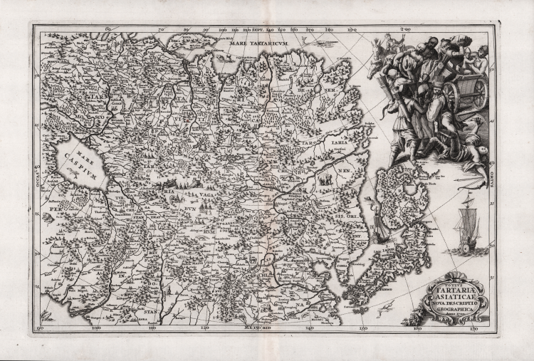
This interesting map covers Tartary, a great tract of northern and central Asia stretching from the Caspian Sea and the Ural Mountains to the Pacific Ocean. The depiction of Japan is very unusual with a large, distorted northern island of Hokkaido (Iedso) connected to Honshu by a narrow isthmus.
The map is finely engraved with mountains, forests and cities with vignettes of animals and encampments. In the top right corner is a vivid illustration of a marauding horde of Tartar warriors attacking a Chinese wagon.
Decorative map by Heinrich Scherer for his Atlas Novus exhibens orbem terraguem per naturae opera, historiae navae acveterus monumenta, artistique geographicae leges et praecepta...published in eight volumes from 1702-1710 in Munich. Scherer, a devout Jesuit, produced this geographical compendium to depict the Catholic hierarchy and the spread of Jesuit missions throughout the world.
Copper engraving, in very good condition.
|
Shirley (BL Atlases) T.SHER-1a #103.
|
Henrick SCHERER (Dilingen 1628 - Monaco 1704)
|
Heinrich Scherer was a devout Jesuit, and professor of mathematics at Munich. His 'Atlas Novus' contained maps of all other parts which showed the spread of Catholicism and Jesuit missions.
|
|
Shirley (BL Atlases) T.SHER-1a #103.
|
Henrick SCHERER (Dilingen 1628 - Monaco 1704)
|
Heinrich Scherer was a devout Jesuit, and professor of mathematics at Munich. His 'Atlas Novus' contained maps of all other parts which showed the spread of Catholicism and Jesuit missions.
|