
| Reference: | S39297 |
| Author | Ferrando BERTELLI |
| Year: | 1568 |
| Zone: | Djerba |
| Printed: | Venice |
| Measures: | 240 x 175 mm |
| Reference: | S39297 |
| Author | Ferrando BERTELLI |
| Year: | 1568 |
| Zone: | Djerba |
| Printed: | Venice |
| Measures: | 240 x 175 mm |
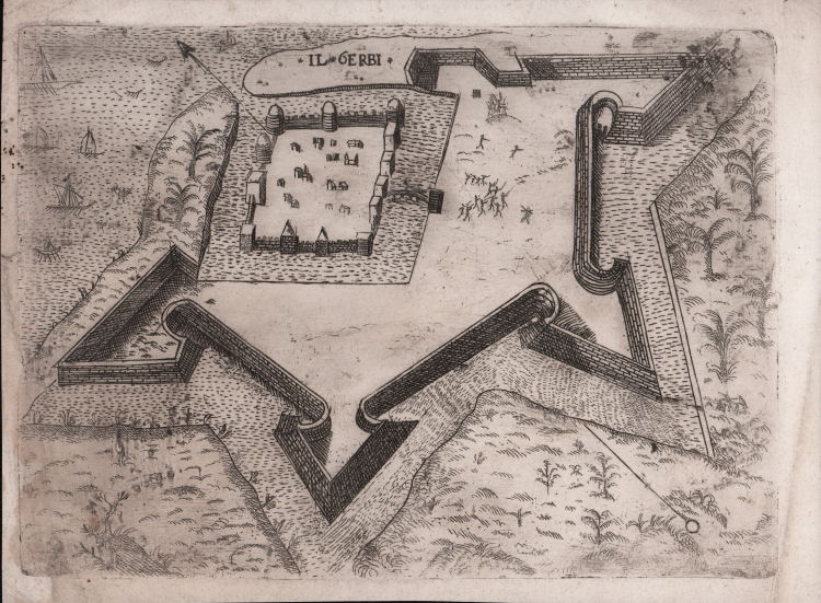
In the top center, we find the title: IL GERBI. Map oriented with the northeast at the top.
Anonymous work, without editorial indications, depicting the fort of Houmt Souk, north of Dijerba. The island was the base of the famous Muslim pirate Darghut Pasha and was the scene of an epic battle (1559-60) against the allied Christian forces commanded by King Philip II of Spain. In an attempt to reconquer Tripoli, which had been occupied in 1551 by the Ottomans, Philip organized a great naval expedition. The campaign ended with a resounding defeat: the Christian fleet was intercepted and surprised near the island of Djerba by the forces of Admiral Piyale Paza, in May 1560, and about half of the ships were sunk or captured. This event marked the height of Ottoman domination in Mediterranean waters. Darghut, to celebrate the victory, erected a pyramid composed of about 5,000 skulls of Christian soldiers. The event aroused great interest, and the fortification was immediately the subject of reproduction in print. The first representation was that of Antonio Lafreri, whose print of occasion came to light during the course of the battle, in 1560. The first state of the paper is printed with the addition of an extensive explanatory typographical text of the table, dated March 29, 1560, when the battle was in full swing. It speaks of “SUCCESSO DEL ARMATA DE Christiani che si trovava in Barberia” and is clearly a work of propaganda. Later printings of the plate, however, lack this emphatic description, probably due to the unexpected failure of the mission.
This small reduction is attributed to the publisher Ferrando Bertelli and replicates that of Paolo Forlani in 1567. The table is known both through specimens preserved in sixteenth-century composite Atlases and for others included in the first edition of Civitatum aliquot insigniorum et locorum, magis munitorum exact delineatio..., published by Ferrando Bertelli in Venice in 1568.
“Altra opera di notevole interesse nell’ambito della cartografia urbana rinascimentale è il Civitatum aliquot insigniorum et locorum… di Ferdinando o Ferrando Bertelli. Bertelli nasce a Boarno di Salò, l’odierna Vobarno, intorno al 1520. Incisore, editore, calcografo e mercante di stampe attivo a Venezia all’insegna di S. Marco in Merzaria. Poco conosciamo della sua vita, di certo collaborò con Camocio e con Paolo Forlani per l’edizione e la vendita di incisioni, carte geografiche e piante di città. Nel filone dell’iconografia urbana, Ferrando si inserì nel periodo di iniziale fervore editoriale, che coinvolse molti degli editori veneziani. La sua opera più importante è appunto la raccolta dal frontespizio bilingue, italiano e latino, Civitatum aliquot insigniorum et locorum, magis munitorum exacta delineatio: cum additione aliquot insularum principalium. Disegni di alcune più illustri città, et fortezze del mondo, con aggionta di alcune Isole principali, con imprint Ferrando Bertelli formis M.D.LXVIII (1568). Si tratta di un’opera molto particolare, priva di indice, e quindi, anche in questo caso come già abbiamo visto per il “Primo Libro” di Forlani-Zenoi, ogni esemplare esaminato risulta diverso dall’altro. Questa peculiarità avvalora l’ipotesi che le raccolte urbane venissero assemblate secondo la richiesta del committente. La mancanza di indice, unitamente al fatto che il frontespizio venne in seguito utilizzato da Donato Bertelli (con il quale non si è potuto stabilire un legame di parentela) fa sì che sotto lo stesso titolo possano talvolta ritrovarsi collezioni eterogenee, sia per soggetti che per numero di immagini” (S. Bifolco, Città e Fortezze Principali del Mondo. Le prime raccolte italiane di cartografia urbana e gli isolari del XVI secolo in S. Bifolco – F. Ronca, “Cartografia e topografia italiana del XVI secolo”, p. 123).
Etching and engraving, printed on contemporary laid paper, with margins, small restorations perfectly executed in the left side, otherwise in good condition.
Bibliografia
Bifolco-Ronca, Cartografia e topografia italiana del XVI secolo, tav. 137; Meurer (2002): n. 125; Tavernari (2014): n. 148; Nordenskiöld (1981): n. 12(57); cfr. Valerio (1998): p. 43, n. 57.
Ferrando BERTELLI (attivo a Venezia seconda metà del XVI secolo)
|
Bertelli family represents the largest group of publishers, engravers, cartographers and merchants of prints of the sixteenth century. Ferrando Bertelli was the most productive, active between 1570, the 1560th, but maps of the last quarter of the century are known by the names of Andrea, Donato, Lucca, Nicholas and Peter. This was mainly active in Padua, where he led a workshop in letterpress and engravings. The earliest records show the asset at the date of 1589 as an engraver of several plates for an edition entitled Diversarum nationum habitus which was published in collaboration with Alciato Alciati. Pietro Bertelli had a library in Padua "the banner of the Angel". At his death the business was inherited by his son Francis. Bertelli was wandering engraver, copperplate engraver and publisher, print dealer active in Venice between 1561 and 1572. We do not have the precise biographical Bertelli.
He teamed with Camocio and the Forlani for the edition and trade cards and plants, they should also become the core business of spreading in the city by Italian and foreign ones, increasing the development of cartography. As a publisher chalcographer emerged from his workshop papers invention of Giacomo Gastaldi, Pirro Ligorio etc.. Although numerous papers of Drawings of the most illustrious cities and fortresses in the world (Venice 1568) bear his signature. Of 1572 is his last edition, the famous islands, harbors, fortresses … Sig.ria subject to Venice, a collection of 88 maps and charts, loose and perhaps already published some of them attributable to the engraving by Martin Rota Sibenik . Later, Ferrando mapss were reprinted by Donato Bertelli (by which we can not determine whether there were family ties) and Donato Rascicotti. Bibliography: Valerio, Cartographers Veneti, p. 149.
|