- New

| Reference: | S49238.108 |
| Author | Georg BRAUN & Franz HOGENBERG |
| Year: | 1572 ca. |
| Zone: | Casablanca, Azemmour, Diu, Goa |
| Printed: | Antwerpen & Cologne |
| Measures: | 470 x 345 mm |
| Reference: | S49238.108 |
| Author | Georg BRAUN & Franz HOGENBERG |
| Year: | 1572 ca. |
| Zone: | Casablanca, Azemmour, Diu, Goa |
| Printed: | Antwerpen & Cologne |
| Measures: | 470 x 345 mm |
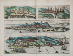
The image contains four distinct views: Anfa (modern-day Casablanca), Azemmour (both in Morocco), Diu, and Goa (both in India). Each view showcases detailed illustrations of the cities’ layouts, architecture, and surroundings, providing an essential historical record of these locations. The plate is part of the first volume of of Civitates Orbis Terrarum, published in 1572.
This view from Braun & Hogenberg captures the essence of four critical cities in the Portuguese Empire's network during the late 16th century. Each city played a unique role in the geopolitical landscape of the time, whether as military strongholds, commercial hubs, or centers of cultural exchange. The detailed representation of these cities not only reflects their importance but also provides a visual record of the era's complex interactions between European colonial powers and the diverse regions they sought to control.
Il Civitates Orbis Terrarum è il primo atlante devoto esclusivamente alle piante e vedute delle principali città del mondo. Stampato in sei volumi tra il 1572 ed il 1617 ebbe grande fortuna e diffusione, tanto che ne furono stampate diverse edizioni tradotte in latino, tedesco e francese.
Il primo volume delle Civitates Orbis Terrarum fu pubblicato a Colonia nel 1572. Il sesto e ultimo volume apparve nel 1617. Questo grande atlante di città – cartografia urbana - curato da Georg Braun e inciso in gran parte da Franz Hogenberg, conteneva 546 prospettive, vedute a volo d'uccello e vedute cartografiche di città di tutto il mondo. Franz Hogenberg realizzò le tavole dei primi quattro volumi e Simon van den Neuwel (Novellanus, attivo dal 1580) quelle dei volumi V e VI.
Georg Braun (1541-1622), un ecclesiastico di Colonia, fu il principale redattore dell'opera e fu molto aiutato nel suo progetto dalla vicinanza e dal continuo interesse di Abraham Ortelius, il cui Theatrum Orbis Terrarum del 1570 fu, come raccolta sistematica e completa di mappe di stile uniforme, il primo vero atlante. Le Civitates, in effetti, erano destinate ad accompagnare il Theatrum, come indicato dalla somiglianza dei titoli e dai riferimenti contemporanei sulla natura complementare delle due opere. Tuttavia, le Civitates erano progettate per avere un approccio più popolare, senza dubbio perché la novità di una raccolta di piante e vedute di città rappresentava un'impresa commerciale più rischiosa di un atlante mondiale, per il quale c'erano stati diversi precedenti di successo. Franz Hogenberg (1535-1590) era figlio di un incisore di Monaco che si era stabilito a Malines. Incise la maggior parte delle tavole del Theatrum di Ortelius e la maggior parte di quelle delle Civitates, e potrebbe essere anche indicato come il responsabile dell'origine del progetto.
Oltre un centinaio di artisti e cartografi diversi, il più importante dei quali fu l'artista di Anversa Georg Hoefnagel (1542-1600), fornirono i disegni per le tavole delle Civitates. Hoefnagel non solo contribuì alla maggior parte del materiale originale per le città spagnole e italiane, ma rielaborò e modificò anche quello di altri collaboratori. Dopo la morte di Hoefnagel, il figlio Jakob continuò il lavoro per le Civitates.
Gli autori della raccolta si proponevano di raffigurare "non icones et typi urbium", cioè non immagini generiche e tipizzate, "sed urbes ipsae admirabili caelaturae artificio, spectantium oculis subiectae appareant": non intendeva alludere o idealizzare, ma rappresentare fedelmente sulla carta, riprodurre esattamente, e in tempo reale, ciò che l'occhio vede, come annunciato nella prefazione al primo volume delle Civitates Orbis Terrarum.
Acquaforte, finemente colorata a mano, in ottimo stato di conservazione.
Bibliografia
Van der Krogt 4, 4659; Fauser, 4659; Taschen, Braun and Hogenberg, p.256.
|
George Braun (1541-1622), cleric of Cologne, was the principal editor of the Civitates Orbis Terrarum, and was greatly assisted in his project by the close, and continued interest of Abraham Ortelius, whose Theatrum Orbis Terrarum of 1570 was, as a systematic and comprehensive collection of maps of uniform style, the first true atlas.
Franz Hogenberg (1535-1590) was the son of a Munich engraves who settled in Malines. He engraved most of the plates for Ortelius's Theatrum and the majority of those in the Civitates, and may have been responsible for originating the project.
|
|
George Braun (1541-1622), cleric of Cologne, was the principal editor of the Civitates Orbis Terrarum, and was greatly assisted in his project by the close, and continued interest of Abraham Ortelius, whose Theatrum Orbis Terrarum of 1570 was, as a systematic and comprehensive collection of maps of uniform style, the first true atlas.
Franz Hogenberg (1535-1590) was the son of a Munich engraves who settled in Malines. He engraved most of the plates for Ortelius's Theatrum and the majority of those in the Civitates, and may have been responsible for originating the project.
|