
| Reference: | MS4748 |
| Author | Willem Janszoon BLAEU |
| Year: | 1640 ca. |
| Zone: | Bermuda |
| Printed: | Amsterdam |
| Measures: | 530 x 405 mm |
| Reference: | MS4748 |
| Author | Willem Janszoon BLAEU |
| Year: | 1640 ca. |
| Zone: | Bermuda |
| Printed: | Amsterdam |
| Measures: | 530 x 405 mm |
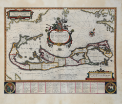
Fine example of Blaeu's highly sought-after map of Bermuda, that shows a detailed survey of the islands and the coast of North America.
This map is based on Richard Norwood’s survey on behalf of the Bermuda Company, conducted in 1617 from a canoe. Norwood made a map of his work, registered in 1622, but no known example survives today. John Speed created a derivative map which was included in his Prospect of the Most Famous Parts of the World (1627). The plate for the Speed map was originally made by Jodocus Hondius, the Younger. After Hondius died in 1629, the plate was sold to Blaeu, who re-issued the handsome map.
The engraving actually includes two maps of Bermuda of different scales. Nestled within the hook of the island is another, smaller depiction of Bermuda, placed there to show its position and size relative to Cape Cod, Nova Scotia and Virginia. (Roanoke, Cape Henry and Cape Charles are all named). This design proved confusing to some later copiers, who dispensed with the mainland in their renditions while mistakenly retaining the smaller “Bermuda,” thereby transforming it into a small island off the coast of Bermuda.
Willem Janszoon Blaeu, started in 1599 his business as a builder of globes and astronomical instruments in Amsterdam. In 1630, after buying some plates of the Mercator atlas from Jodocus Hondius II, he was able to publish a volume of 60 maps under the title Atlantis Appendix. Five years later, he published the first two volumes of his atlas Atlas Novus or Theatrum Orbis Terrarum, in six books. After his death, Joan (Johannes) continued his father's work, completing the entire six-volume Atlas Novus series around 1655. He was also the author of an Atlas Maior sive Cosmographia Blaviana, in 12 volumes published in 1662 -72.
Bibliografia
Palmer, M. (Bermuda maps) #7; Van der Krogt, P. (Atlantes) 9660:2.
Willem Janszoon BLAEU (Uitgeest 1571- Amsterdam 1638)
|
At the beginning of the seventeenth century Amsterdam was becoming one of the wealthiest trading cities in Europe, the base of the Dutch East India Company and a centre of banking and diamond trades, its people noted for their intellectual skills and splendid craftsmanship.
At this propitious time in the history of the Northern Provinces, Willem Janszoon Blaeu, who was born at Alkmaar in 1571 and trained in astronomy and the sciences by Tycho Brahe, the celebrated Danish astronomer, founded a business in Amsterdam in 1599 as a globe and instrument maker.
It was not long before the business expanded, publishing maps, topographical works and books of sea charts as well as constructing globes.
His most notable early work was a map of Holland (1604), a fine World Map (1605-06) and Het Licht der Zeevaerdt (The Light of Navigation), a marine atlas, which went through many editions in different languages and under a variety of titles.
At the same time Blaeu was planning a major atlas intended to include the most up-to-date maps of the whole known world but progress on so vast a project was slow and not until he bought between 30 and 40 plates of the Mercator Atlas from Jodocus Hondius II to add to his own collection was he able to publish, in 1630, a 60-map volume with the title Atlantis Appendix.
It was another five years before the first two volumes of his planned world atlas, Atlas Novus or the Theatrum Orbis Terrarum were issued. About this time he was appointed Hydrographer to the East India Company.
In 1638 Willem Blaeu died and the business passed into the hands of his sons, Joan and Cornelis, who continued and expanded their father's ambitious plans.
After the death of Cornelis, Joan directed the work alone and the whole series of 6 volumes was eventually completed about 1655.
As soon as it was finished he began the preparation of the even larger work, the Atlas Major, which reached publication in 1662 in II volumes (later editions in 9-12 volumes) and contained nearly 6oo double-page maps and 3,000 pages of text.
This was, and indeed remains, the most magnificent work of its kind ever produced; perhaps its geographical content was not as up-to-date or as accurate as its author could have wished, but any deficiencies in that direction were more than compensated for by the fine engraving and colouring, the elaborate cartouches and pictorial and heraldic detail and especially the splendid calligraphy.
In 1672 a disastrous fire destroyed Blaeu's printing house in the Gravenstraat and a year afterwards Joan Blaeu died. The firm's surviving stocks of plates and maps were gradually dispersed, some of the plates being bought by F. de Wit and Schenk and Valck, before final closure in about 1695.
It ought to be mentioned here that there is often confusion between the elder Blaeu and his rival Jan Jansson (Johannes Janssonius). Up to about 1619 Blaeu often signed his works Guilielmus Janssonius or Willems Jans Zoon but after that time he seems to have decided on Guilielmus or G. Blaeu.
|