| Reference: | MS1270 |
| Author | Henri Abraham CHATELAIN |
| Year: | 1708 ca. |
| Zone: | Mexico |
| Printed: | Amsterdam |
| Measures: | 430 x 370 mm |
| Reference: | MS1270 |
| Author | Henri Abraham CHATELAIN |
| Year: | 1708 ca. |
| Zone: | Mexico |
| Printed: | Amsterdam |
| Measures: | 430 x 370 mm |
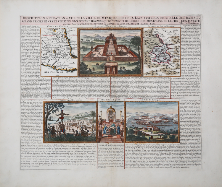
Description, Situation & Vue De La Ville De Mexique, Des Deux Lacs Sur Lesquels Elle Est Batie, Du Grand Temple De Cette Ville, Des Sacrifices D'Hommes Qu'on Y Faisout, De L'Idole Des Mexicans, Due Leurs Jeux, Divertis Semens, Costumes…
Decorative map of the environs and City of Mexico, along with views of the Pyramid and 3 other scenes, from Chatelain's Atlas Historique.
Henri Abraham Chatelain (1684 - 1743) was a Huguenot pastor of Parisian origins. He is best known as a Dutch cartographer and more specifically for his cartographic contribution in the seminal seven volume Atlas Historique, published in Amsterdam between 1705 and 1720. Innovative for its time, the Atlas Historique combined fine engraving and artwork with scholarly studies of geography, history, ethnology, heraldry, and cosmography. Some scholarship suggests that the Atlas Historique was not exclusively compiled by Henri Chatelain, as is commonly believed, but rather was a family enterprise involving Henri, his father Zacharie and his brother, also Zacharie.
Copper engraving, with fine later hand colouring, in excellent condition.
Henri Abraham CHATELAIN (1684 - 1743)
|
Henri Abraham Chatelain (1684 - 1743) was a Huguenot pastor of Parisian origins. He is best known as a Dutch cartographer and more specifically for his cartographic contribution in the seminal seven volume Atlas Historique, published in Amsterdam between 1705 and 1720. Innovative for its time, the Atlas Historique combined fine engraving and artwork with scholarly studies of geography, history, ethnology, heraldry, and cosmography. Some scholarship suggests that the Atlas Historique was not exclusively compiled by Henri Chatelain, as is commonly believed, but rather was a family enterprise involving Henri, his father Zacharie and his brother, also Zacharie. The Atlas Historique published by Chatelain was part of a major work of its time, an encyclopaedia in seven volumes including geography as one of its main subjectes. The text was by Nicholas Gueudeville and the maps by Chatelain. The Atlas included one of the finest maps of America (4 sheets) surrounded by vignettes and decorative insets.
1705-20 Atlas Historique:Amsterdam (maps by Chatelain based on G.Delisle)
Further issues to 1739
|