
| Reference: | 4846 |
| Author | Johannes VAN KEULEN |
| Reference: | 4846 |
| Author | Johannes VAN KEULEN |
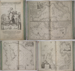
2°, half-leather binding of the nineteenth century, with the back redone. Engraved frontispiece, 2 sheets, 94 pp.. and 32 double page charts (3 of which are folded several times), numerous plans and profiles of coastline nautical engraved woodcut in the text. Published in Amsterdam, at the Johannes van Keulen, 1705.
The publishing house van Keulen was founded around 1678 by the founder Johannes which took over in 1695, his son Gerard, well versed in nautical disciplines and skilled engraver, who engraved the specialization mapping company that made her famous in the Netherlands and Europe for two centuries to follow. A publishing house included a substantial portfolio of loose manuscript maps, a nautical atlas called Le Grand Nouvel Atlas de la Mer and the monumental De Nieuwe Groote Zee-Lichtende Fakkel, published between 1681 and 1684 in five folio volumes, to which - in 1753 - he added a sixth for navigation along the coast of Asia.
In accordance with the “Spieghel der Zeewaerdt” by L. J. Waghenaer, the first volume describes the northern seas from Holland up to the Hudson Strait, while the second volume is devoted to sailing from the North Sea to continental European coast to the Cape Verde Islands. The third volume describes instead the Mediterranean who held particular importance as a crossroads for trade between the East and the West. The fourth volume covers the West Indies and the eastern coast of North America, while the fifth contains the maps of West Africa to the Cape of Good Hope and eleven maps of Brazil, as well as some works from the Far East that was a prelude to the compilation of sixth volume.
The Asian coasts were in fact of major importance for the Netherlands, who had founded a trading empire, and then the maps of those regions remained for a long manuscript, so that it was prevented from spreading outside of the VOC fleet, until 1753 , when it had already been in circulation for decades nautical atlases published by the British and the French. The Nieuwe Groote Zee-Lichtende Fakkel, which included nautical instructions, general and special cards, port plans and views of the coast, was translated into several languages and had several editions.
The third book, dedicated to the Mediterranean, was an Italian edition, published in 1695 under the title Della nuova grande illuminante face del mare and reprinted in 1705. He curator was J. Vooght, while the Italian translation is by the patavino Mose Giron. Several maps bearing dates subsequent to the publication of pilot book, because while the text did not require updates, the maps were replaced over time as needed.
Rare example of the Italian translation of the Zee-Fakkel, the third part concerning the Mediterranean, the only translated into Italian. Koeman describes only two copies of the first edition of 1695 (one preserved in the Maritime Museum in Amsterdam, without maps, and a second in the Topkapi Library in Istanbul) and a single copy of the 1705, always kept at the Maritime Museum in Amsterdam, with 25 nautical charts. A copy of the book appeared at auction at Christie's in London in May 1995. The work contained up to 39 charts. In all these copies, as in our example, the index, however, lists only 20 nautical charts, demonstrating the fact that the atlases were assembled with a variable number of maps.
Bookplate of Horace Landau.
Bibliografia: Koeman, Atlas Neerlandici, vol. IV, p. 346, 108; P. Presciuttini, Sulla Cresta dell’onda.it ; Pavone Vanavese, Coste del Mediterraneo nella cartografia europea 1500-1900, p. 179, 318.
Johannes VAN KEULEN (1654 - 1715)
|
The Van Keulen dynasty of publishers, printers, booksellers, and cartographers produced the most comprehensive and up-to-date Dutch nautical atlases. Johannes van Keulen (1654–1715) founded a book and instrument business in Amsterdam in 1678 and in 1680 obtained the privilege of printing nautical guides and atlases from Holland and West Friesland. His first major work was the Nieuwe Lichtende Zee-Fakkel, illustrated by Jan Luyken, with maps drawn by Claes Jansz Vooght; five volumes were published between 1681 and 1684. Van Keulen also produced a Zee-Atlas ofte Water-werelt. The Van Keulen family continued to operate for nearly two centuries; Gerard (1678 - 1726) produced new editions of his father's works, numerous manuscript maps, and was appointed hydrographer to the Dutch East India Company (VOC) in 1706; his son Jan II van Keulen (1704 - 1770) took over the business in 1726 and published a new edition of the Asiatic volume of the Zee-Atlas; he was appointed cartographer to the VOC in 1743. After Jan II's death, his sons Cornelis Buijs and Gerard Hulst van Keulen ran the family business. Gerard (1733 - 1801) added a further volume to the Zee-Fakkel containing East India material derived from the VOC. Gerard, in addition to publishing the first nautical almanac in Dutch in 1788, was one of the three original members of the commission established by the Dutch government in 1787 to solve the problem of finding longitude at sea. Gerard's son, Jan III, was the last van Keulen to run the company.
|