
| Reference: | VR75 |
| Author | Tobias Conrad LOTTER |
| Year: | 1770 |
| Zone: | Mediterranean Sea |
| Printed: | Augsburg |
| Measures: | 1315 x 535 mm |
| Reference: | VR75 |
| Author | Tobias Conrad LOTTER |
| Year: | 1770 |
| Zone: | Mediterranean Sea |
| Printed: | Augsburg |
| Measures: | 1315 x 535 mm |
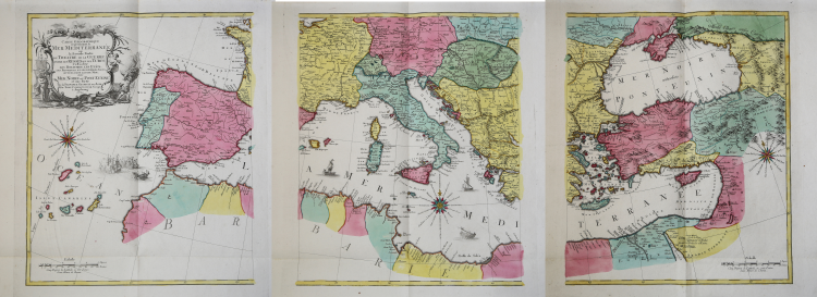
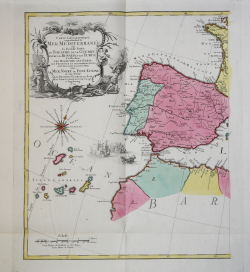
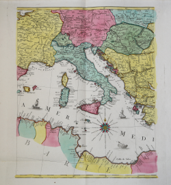
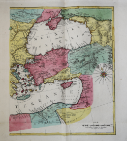
Carte Geographique representant la Mer Mediterranée ou la seconde Partie du Theatre de la Guerre entre les Russes et les Turcs C'est-à-dire les Roiaumes, les Etâts, les Provinces et les Diverses Isles situées dans la dite Mer, avec la Mer Noire ou Pont Euxine et une Partie de la Province Georgie en Asia / Par Tobie Conrad Lotter Geogr. À Augsbourg 1770.
Printed on 3 sheets, joined. Upper and lower margin cut close to the neat line, as issued. Full body colour.
A beautiful map of the Mediterranean Sea. Embellished with three compass roses and sailing vessels, including a scene on a naval battle in the Atlantic off of Gibraltar.
The map was printed in the middle of the Russo-Turkish War of 1768–1774. Lotter and other published provided the public with maps on which they could follow the progress of this conflict.
The Russo-Turkish War of 1768–1774 was a decisive conflict that brought Southern Ukraine, Northern Caucasus, and Crimea within the orbit of the Russian Empire.
Following the border incident at Balta, Sultan Mustafa III declared war on Russia on September 25, 1768. The Turks formed the alliance with the Polish opposition forces of the Bar Confederation, while Russia was supported by Great Britain, who offered naval advisers to the Imperial Russian Navy.
The Polish opposition was defeated by Aleksandr Suvorov. After that, he was transferred to the Turkish theatre of operations, where in 1773 and 1774 he won several minor and major battles for Russia following the previous successes of the Russian Field-Marshal Count Peter Rumiantsev at Larga and Kagul.
Tobias Conrad Lotter (1717 - 1777) was a German engraver and map publisher. Lotter married Euphrosina Seutter (1709-1784), elder daughter of Matthäus Seutter. He began working at his is father-in-law's map business about 1740. Between 1740 and 1744 he produced, under Seutter's imprint, the Atlas minor, Praecipua orbis terrarum imperia, regna et provincias, Germania potissimum tabelli. Upon Seutter's death, in 1757, the firm's stock was taken over by his son, Albrecht Karl Seutter (1722-1762), who himself died in 1762, just a few years later. The remaining Suetter map plates were subsequently divided between Lotter and the publisher Johan Mitchell Probst (1727 - 1776). With the support of his sons, Matthäus Albrecht (1741-1810), Georg Friedrich (1744-1801) and Gustav Conrad (1746-1776), Tobias Conrad Lotter succeeded in building on the economic success and professional reputation of his father-in-law. In time, Lotter became one of the most prominent mid-18th century map publishers working in the German school.
Copperplate with fine original colouring, good condition.
Tobias Conrad LOTTER (1717 - 1777)
|
Tobias Conrad Lotter (1717 - 1777) was a German engraver and map publisher. Lotter was the son of a baker and city guardsman, but married Euphrosina Seutter (1709-1784), elder daughter of the prominent map publisher Matthäus Seutter. He began working at his is father-in-law's map business about 1740. Between 1740 and 1744 he produced, under Seutter's imprint, the Atlas minor, Praecipua orbis terrarum imperia, regna et provincias, Germania potissimum tabelli. Upon Seutter's death, in 1757, the firm's stock was taken over by his son, Albrecht Karl Seutter (1722-1762), who himself died in 1762, just a few years later. The remaining Suetter map plates were subsequently divided between Lotter and the publisher Johan Mitchell Probst (1727 - 1776). With the support of his sons, Matthäus Albrecht (1741-1810), Georg Friedrich (1744-1801) and Gustav Conrad (1746-1776), Tobias Conrad Lotter succeeded in building on the economic success and professional reputation of his father-in-law. In time, Lotter became one of the most prominent mid-18th century map publishers working in the German school. After Lotter's death in 1777, the business was taken over by his two eldest sons, who, lacking their father's business acumen, presided over the firm's slow decline. It was nonetheless passed on to a subsequent generation of Lotters, Matthäus Albrecht Lotter's sons, Gabriel (1776-1857) and Georg Friedrich (1787-1864), who pushed it into further decline until it faded out in the early-19th century.
c.1744 Atlas Minor
1760 -62 Atlas Geographicus portabilis
c.1770 Atlas Novus
1776 A map of the most inhabited part of New England
1778 Atlas Geographique
1778 (M.A. Lotter) World Map showing Cook’s voyages
|