

| Reference: | VR65FR |
| Author | Jacques Nicolas BELLIN |
| Year: | 1745 |
| Zone: | Mediterranean Sea |
| Printed: | Paris |
| Measures: | - x - mm |
| Reference: | VR65FR |
| Author | Jacques Nicolas BELLIN |
| Year: | 1745 |
| Zone: | Mediterranean Sea |
| Printed: | Paris |
| Measures: | - x - mm |
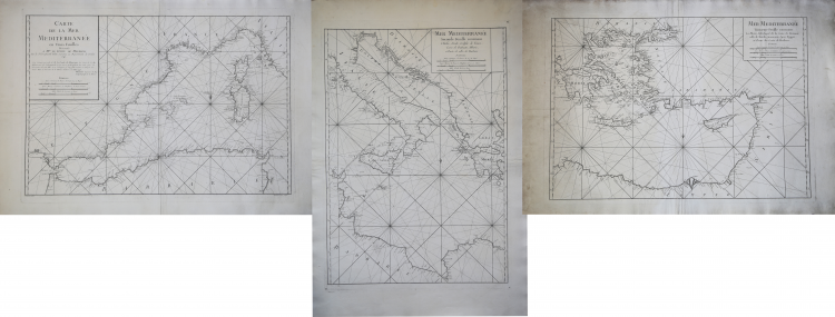
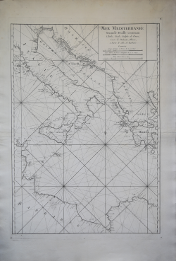
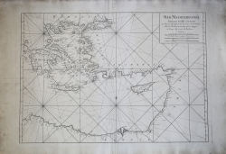
Carte de la Mer Mediterranée en Trois Feuilles. Presentéè a M.gr Le Comte de Maurepas Par le S.r Grognard Pilote entretenu au Departement de Toulone 1745. J’ay Examiné par ordre de M. Le Comte de Maurepas. La Carte de la Mer Mediterranée du S.r Grognard et j’ay trové qu’elle pouvoit etre utile pour la Navigation de cette Mere, et en consequence je l’ay fait executer au Dépost des Cartes Plans et Journaux de la Marine. A Paris ce I.er Mars 1745. Bellin Ingegnieur du Roy et Hydrographe de la Marine & Mere Mediterranèe Second Feuille contenant L’Italie, SIcile, Golphe de Venise, Costes de Dalmatie, Albanie, et Partie de celles de Barbarie & Mere Mediterranèe Troisieme Feuille contenant La Morée, L’Archipel, Et les Costes de Romanie celels de Natolie, Caramanie, Syrie, Egypte, et Partie des Costes de Barbarie.
Taken from: L’Hydrographie Francoise Recueil des Cartes Generales et Particulieres qui ont ete Faites pour le Service des Vaisseaux du Roy. Par ordre des Ministres de la Marine depuis 1737. jusqu'en 1765. Par le S. Bellin Ingenieur de la Marine et du Depost des Cartes, Plans et Journaux de la Marine, Censeur Royal, de l'Academie de Marine et de la Societe Royale de Londres. Premiere Partie Contenant Les Cartes Marines pour l'Europe et l'Asie. Seconde Partie Contenant Les Cartes Marines pour l’Afrique et l’Amérique. A Paris chez M. Bellin, rue du Doyennen pres St. Louis du Louvre.
Etching, printed on three sheets, respectively of dimensions 550x770 mm, 775x540 mm and 550x780 mm, with the central sheet developing vertically, preventing the perfect overlapping of the three sheets.
Beautiful sexample, with full margins, in perfect condition.
As Bellin himself points out in the title, he was asked to examine this Mr. Grognard map, and having considered it valid, decided to have it printed. We can probably identify the map maker in Arnaud Groignard (1681-1751), a long-time captain of the merchant navy, maritime pilot, hydrograph and shipowner, father of the more famous Antoine Groignard (1727-1799) a military man and engineer, responsible for the construction of many units of the Marine Royale which also held the position of General Engineer of the Navy in 1782.
This map is made on the order of Jean-Frédéric Phélypeaux, count de Maurepas; is included in the famous Hydrographie Françoise, the most important nautical atlas of the 18th century, printed under the direction of the Dépôt des cartes et plans de la Marine by Jacques-Nicola Bellin.
Bibliografia: cfr. O. Chapuis, A la mer comme au ciel: Beautemps-Beaupré & la naissance de lhydrographie, Parigi, 1999, pp. 151-2; cfr. National Maritime Museum, Catalogue of the Library - Vol. Three, Atlas & Cartography, Londra, 1971, pp. 238-241, n. 210; cfr. R. Shirley, Maps in the Atlases of the British Library, Londra, 2004, pp. 1068-1072, M.BELL-1a.
|
S. Bifolco, "Mare Nostrum, Cartografia nautica a stampa del Mar Mediterraneo" (2020), pp. 266-267, tav. 124.
|
Jacques Nicolas BELLIN (1703 - 1772)
|
Jacques-Nicolas Bellin (1703 - 1772) was one of the most important cartographers of the 18th century.
With a career spanning some 50 years, Bellin is best understood as transitional mapmaker spanning the gap
between 18th and early 19th century cartographic styles. His long career as Hydrographer and Ingénieur
Hydrographe at the French Dépôt des cartes et plans de la Marine resulted in hundreds of high quality
nautical charts of practically everywhere in the world. Bellin's work focuses on function and accuracy
tending in the process to be less decorative than the earlier 17th and 18th century cartographic work. In
addition to numerous maps and charts published during his lifetime, many of Bellin's maps were updated
(or not) and published posthumously. He was succeeded as Ingénieur Hydrographe by his student, also a prolific and influential cartographer, Rigobert Bonne.
|
|
S. Bifolco, "Mare Nostrum, Cartografia nautica a stampa del Mar Mediterraneo" (2020), pp. 266-267, tav. 124.
|
Jacques Nicolas BELLIN (1703 - 1772)
|
Jacques-Nicolas Bellin (1703 - 1772) was one of the most important cartographers of the 18th century.
With a career spanning some 50 years, Bellin is best understood as transitional mapmaker spanning the gap
between 18th and early 19th century cartographic styles. His long career as Hydrographer and Ingénieur
Hydrographe at the French Dépôt des cartes et plans de la Marine resulted in hundreds of high quality
nautical charts of practically everywhere in the world. Bellin's work focuses on function and accuracy
tending in the process to be less decorative than the earlier 17th and 18th century cartographic work. In
addition to numerous maps and charts published during his lifetime, many of Bellin's maps were updated
(or not) and published posthumously. He was succeeded as Ingénieur Hydrographe by his student, also a prolific and influential cartographer, Rigobert Bonne.
|