
| Reference: | VR61FR |
| Author | Dépôt des cartes et plans de la Marine |
| Year: | 1737 |
| Zone: | Mediterranean Sea |
| Printed: | Paris |
| Measures: | 1520 x 630 mm |
| Reference: | VR61FR |
| Author | Dépôt des cartes et plans de la Marine |
| Year: | 1737 |
| Zone: | Mediterranean Sea |
| Printed: | Paris |
| Measures: | 1520 x 630 mm |
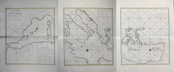
Chart taken from: Le Neptune François ou Recueil des Cartes Marines, Levees et Gravees par Ordre du Roi. Premier Volume, Contenant les Cotes de l'Europe sur l’Ocean. […] Versailles; L’Imprimerie du Département de la Marine [s.d.]
Etching, printed on three sheets, 630x540 mm each. Signed Dheulland sculp.
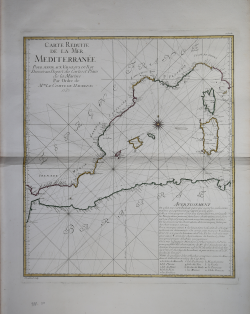
Beautiful example, with original outline colouring, good conditions.
Nautical chart engraved by Guillaume Dheulland (Paris 1700-1770) and printed in 1737 by the Dépôt des cartes et plans de la Marine. As indicated in the title, the map is made by order of Jean-Frédéric Phélypeaux, count de Maurepas (Versailles 1701-1781). Son of Jérôme Phélypeaux, count de Pontchartrain, secretary of state at the navy and in the Chamber of the King, Maurepas, succeeded in this position to his father, only 14 years of age. He became secretary of state to the Navy on 16 August 1723, remaining there until 23 April 1749.
The King understood that to counter the naval power of the English fleet it was necessary to supply the Navy with updated nautical charts. A first attempt was represented by the publication of "Le Neptune François ou recueil des cartes marines levées et gravées par ordre du Roi" (1693), but only in the early eighteenth century was a major campaign launched on the coasts of the Mediterranean and other seas, which led to the creation of numerous maps, collected by the Dépôt des cartes et plans de la Marine, a cartographic service office created in 1720 by Philippe d'Orléans (1674-1723) which, anticipating the current French naval hydrographic and oceanographic service (SHOM), had the task of collecting and preserving nautical plans, maps, newspapers and memoirs relating to the Navy.
The Dépôt des cartes et plans de la Marine quickly became the place of production of the charts. In 1773 he obtained the monopoly of the creation of nautical charts in France.
The Dépôt des cartes et plans de la Marine was started in 1720, with the acquisition of the Neptune François, under the direction of Captain Charles-Hercule d'Albert de Luynes - known as Chevalier de Luynes (1674-1734) - an aristocratic and official of marina, who directed the institute until 1722.
Chapuis ascribed the chart to Jacques-Nicolas Bellin (cfr. A la mer comme au ciel, p. 151): “Le routier général de Méditerranée publié par le Dépôt des cartes et plans de la Marine en 1737, est una carte réduite. Bellin justifie ainsi cette publication: On a fait una carte réduite parce que ce sont les soules cartes marines qui ayent un vrai rapport avec le globe. Dans le mémories accompagnante la carte, il renchérit: Les cartes réduites étant les seules sur lesquelles on peut pointer les toutes avec précision, on a cru devoir changer l’usage qui n’avoit donné jusqu’à ce jour que des cartes plates pour la mer Méditerranée”. La tavola è occasionalmente inserita nelle edizioni de Le Neptune François ou Recueil des Cartes Marines stampate sotto la direzione del Dépôt des cartes et plans de la Marine.
Bibliografia: cfr. O. Chapuis, A la mer comme au ciel: Beautemps-Beaupré & la naissance de lhydrographie, Parigi, 1999, pp. 151-2; National Maritime Museum, Catalogue of the Library - Vol. Three, Atlas & Cartography, Londra, 1971, pp. 236-238, n. 209 (56-58).
|
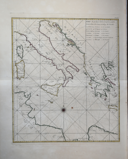
S. Bifolco, "Mare Nostrum, Cartografia nautica a stampa del Mar Mediterraneo" (2020), pp. 264-265, tav. 123.
|
Dépôt des cartes et plans de la Marine
|
The Dépôt de la Marine, known more formally as the Dépôt des cartes et plans de la Marine, was the central charting institution of France. The centralization of hydrography in France began in earnest when Jean-Baptiste Colbert became First Minister of France in 1661. Under his watch, the first Royal School of Hydrography began operating, as did the first survey of France’s coasts (1670-1689). In 1680, Colbert consolidated various collections of charts and memoirs into a single assemblage, forming the core of sources for what would become the Dépôt.
The Dépôt itself began as the central deposit of charts for the French Navy. In 1720, the Navy consolidated its collection with those government materials covering the colonies, creating a single large repository of navigation. By 1737, the Dépôt was creating its own original charts and, from 1750, they participated in scientific expeditions to determine the accurate calculation of longitude.
In 1773, the Dépôt received a monopoly over the composition, production, and distribution of navigational materials, solidifying their place as the main producer of geographic knowledge in France. Dépôt-approved charts were distributed to official warehouses in port cities and sold by authorized merchants. The charts were of the highest quality, as many of France’s premier mapmakers worked at the Dépôt in the eighteenth century, including Philippe Bauche, Jacques-Nicolas Bellin, Rigobert Bonne, Jean Nicolas Buache, and Charles-François Beautemps-Beaupré.
The Dépôt continued to operate until 1886, when it became the Naval Hydrographic Service. In 1971, it changed names again, this time to the Naval and Oceanographic Service (SHOM). Although its name has changed, its purpose is largely the same, to provide high quality cartographic and scientific information to the France’s Navy and merchant marine.
|
|
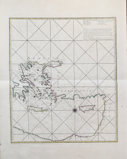
S. Bifolco, "Mare Nostrum, Cartografia nautica a stampa del Mar Mediterraneo" (2020), pp. 264-265, tav. 123.
|
Dépôt des cartes et plans de la Marine
|
The Dépôt de la Marine, known more formally as the Dépôt des cartes et plans de la Marine, was the central charting institution of France. The centralization of hydrography in France began in earnest when Jean-Baptiste Colbert became First Minister of France in 1661. Under his watch, the first Royal School of Hydrography began operating, as did the first survey of France’s coasts (1670-1689). In 1680, Colbert consolidated various collections of charts and memoirs into a single assemblage, forming the core of sources for what would become the Dépôt.
The Dépôt itself began as the central deposit of charts for the French Navy. In 1720, the Navy consolidated its collection with those government materials covering the colonies, creating a single large repository of navigation. By 1737, the Dépôt was creating its own original charts and, from 1750, they participated in scientific expeditions to determine the accurate calculation of longitude.
In 1773, the Dépôt received a monopoly over the composition, production, and distribution of navigational materials, solidifying their place as the main producer of geographic knowledge in France. Dépôt-approved charts were distributed to official warehouses in port cities and sold by authorized merchants. The charts were of the highest quality, as many of France’s premier mapmakers worked at the Dépôt in the eighteenth century, including Philippe Bauche, Jacques-Nicolas Bellin, Rigobert Bonne, Jean Nicolas Buache, and Charles-François Beautemps-Beaupré.
The Dépôt continued to operate until 1886, when it became the Naval Hydrographic Service. In 1971, it changed names again, this time to the Naval and Oceanographic Service (SHOM). Although its name has changed, its purpose is largely the same, to provide high quality cartographic and scientific information to the France’s Navy and merchant marine.
|