| Reference: | VR60FR |
| Author | Georg Louis le ROUGE |
| Year: | 1756 |
| Zone: | Mediterranean Sea |
| Printed: | Paris |
| Measures: | - x - mm |
| Reference: | VR60FR |
| Author | Georg Louis le ROUGE |
| Year: | 1756 |
| Zone: | Mediterranean Sea |
| Printed: | Paris |
| Measures: | - x - mm |
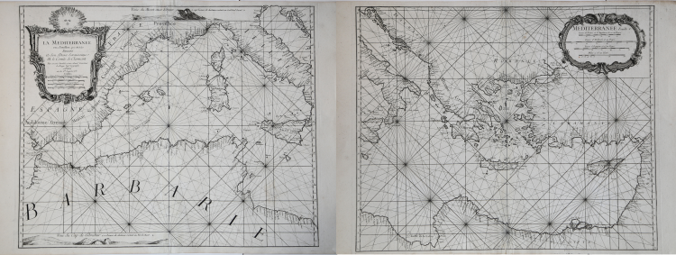
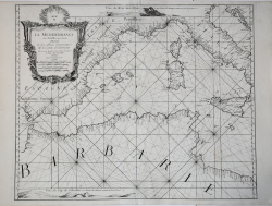
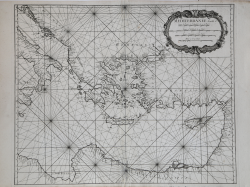
Etching, printed on two sheets, 530x660 each. In the cartouche of the western part the imprint: Le Rouge Ing.r Geographe in Paris rue des G.ds Augustins.
Beautiful example of this uncommon chart of the Mediterranean Sea.
The chart is a close copy - as stated - from the work of Henry Michelot. Title in decorated cartouche placed in the western sheet, top left, which also contains four metric scales; another title is in the scroll of the eastern sheet, where the scales are replicated. This chart does not seem to be included in any of the atlases by Georges-Louis Le Rouge.
Bibliografia: cfr. National Maritime Museum, Catalogue of the Library - Vol. Three, Atlas & Cartography, Londra, 1971, pp. 295-301; cfr. R. Shirley, Maps in the Atlases of the British Library, Londra, 2004, pp. 650-653, M.LER.
|
S. Bifolco, "Mare Nostrum, Cartografia nautica a stampa del Mar Mediterraneo" (2020), pp. 272-273, tav. 127.
|
Georg Louis le ROUGE (1721-1790 circa)
|
A military engineer by profession, Le Rouge took up cartography and over a long period from about 1740 to 1780 produced many attractive works covering a wide range of subjects, including plans of fortifications, military campaigns, town plans as well as the more usual atlases and sea charts.
1741-62 Atlas General
1742 Recueil des cartes Nouvelles (including a reissue on reduced scale of Henry Popple’s map of America of 1733)
1748 Atlas Nouveau Portatif (4to)
1756,c.1767 re-issued
1755 Recueil des Plans de l’ Amerique(8vo)
1756 Introduction de Geographie
1758 Atlas Prussien
1759 recueil des villes ,portes d’ Angleterre (8vo)
1760 Topographie des Chemins d’ Angleterre (8vo)
1778 Atlas Ameriquain Septentrional
|
|
S. Bifolco, "Mare Nostrum, Cartografia nautica a stampa del Mar Mediterraneo" (2020), pp. 272-273, tav. 127.
|
Georg Louis le ROUGE (1721-1790 circa)
|
A military engineer by profession, Le Rouge took up cartography and over a long period from about 1740 to 1780 produced many attractive works covering a wide range of subjects, including plans of fortifications, military campaigns, town plans as well as the more usual atlases and sea charts.
1741-62 Atlas General
1742 Recueil des cartes Nouvelles (including a reissue on reduced scale of Henry Popple’s map of America of 1733)
1748 Atlas Nouveau Portatif (4to)
1756,c.1767 re-issued
1755 Recueil des Plans de l’ Amerique(8vo)
1756 Introduction de Geographie
1758 Atlas Prussien
1759 recueil des villes ,portes d’ Angleterre (8vo)
1760 Topographie des Chemins d’ Angleterre (8vo)
1778 Atlas Ameriquain Septentrional
|