

| Reference: | VR56FR |
| Author | Henry MICHELOT & Laurent BREMOND |
| Year: | 1726 |
| Zone: | Mediterranean Sea |
| Printed: | Marsiglia |
| Measures: | - x - mm |
| Reference: | VR56FR |
| Author | Henry MICHELOT & Laurent BREMOND |
| Year: | 1726 |
| Zone: | Mediterranean Sea |
| Printed: | Marsiglia |
| Measures: | - x - mm |
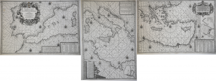
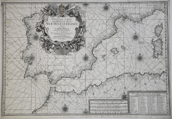
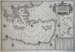
Nouvelle Carte Generalle de la Mer Mediterranée Dediée a Monseigneur Le Grand Prieur General des Galeres de France. Par ses tres humbles Servoteurs Michelot Hidrographe et Pilot Real des Galeres du Roy et Bremond Hidrographe du Roy et de la Ville. Avec Privilege du Roy.
Etching, printed on three sheets, respectively 499x711 mm, 700x490 mm and 468x693 mm. Imprint in the cartouche: Ce Vend chez Laurent Bremond sur le Port in Marseille au Coin de Reboul; bottom right, the engraver's signature: Gravéè par P. Starckman.
Beautiful example, in excellent condition.
Mediterranean Sea charts, which is divided into three parts. In the western sheet, at the bottom, a box contains the metric scales (repeated in the central sheet, bottom right, and in the eastern one, top right): Echelle de Lieues Françoises et Angloises, a 20 pour Degré; Echelle de Lieues d'Hollande, a 15 pour un Degré; Echelle de Lieues d'Espagne, à 17 1/2 pour un Degré; Echelle de Milles, a 75 pour un Degré, Selon l'usage de la Mediterranée.
Below, in a box, we find the "Noms des Isles and those Ports contenues dues cette Carte", a list of 56 toponyms. In the central sheet, the second box shows the "Noms des Isles and those Ports contenues dans cette Carte", list of further 64 toponyms; in the upper right, in a scroll, the nautical plan of Tripoli is represented. In the eastern folio, a box shows the "Noms des Isles et quelques Caps contenues dans Cette Carte", list of 80 place names on the Aegean Sea.
The chart is dedicated to Jean Philippe d’Orleans (1702 - 1748), bâtard d’Orléans, called le Chevalier d’Orléans or le Grand Prieur d’Orléans, illegitimate son of Philip d’Orléans, nephew and son-in-law of Louis XIV.
The work was the second plate of the nautical atlas that Michelot and Bremond made in the first twenty years of the eighteenth century. The technique adopted for the coastal design and the placement of toponyms prove the derivation of this chart directly from manuscript models. The central sheet shows unusually the north to the left, unlike the other two sheets, therefore, developing vertically, it cannot be joined on the other two.
Henry Michelot, after his success with the publication of his nautical guide "Le Portulan de Partie de la Mer Méditerranée, ou Le vray Guide des Pilotes Costiers" (1703), tried to capitalize it by joining Laurent Bremond. At the beginning of the 18th century, Henry Michelot and Laurens Bremond published two important nautical atlases of the Mediterranean and nautical plans widely used by coastal mariners.
The charts are interesting and important for the reliability derived from the experience of Michelot who, unlike the subsequent "geographers of the Dépôt des cartes et de la Marine" like Jacques-Nicolas Bellin had a long experience at sea.
The first atlas produced contains 16 maps, on a small scale, of the Mediterranean and the Atlantic coast near the Strait of Gibraltar, supplemented by one or more coastal profiles. The dates of the charts are between 1715 and 1726; in this period Michelot signed himself as Hydrographe et Pilote Real des Galères du Roy (hydrographer and pilot of the royal galley).
Little is known about the co-creator of the work Laurent Bremond. In the nautical collection his name always happens to that of Michelot, and he is qualified as Hydrographe du Roy and de la Ville. Bremond seems to have been the publisher and seller of the nautical collection, the commercial strength of the company; owner of a sort of shop near the port. All charts are clearly marked: Ce vendent a Marseille chez Laurens Bremond sur le Port au coin de Reboul (sold in Marseille by Laurens Bremond in the port at the corner of Reboul).
Bibliografia: National Maritime Museum, Catalogue of the Library - Vol. Three, Atlas & Cartography, Londra, 1971, pp. 262-263, n. 219 (2-4); R. Shirley, Maps in the Atlases of the British Library, Londra, 2004, pp. 1233-1234, M.MICH-1a.
|
S. Bifolco, "Mare Nostrum, Cartografia nautica a stampa del Mar Mediterraneo" (2020), pp. 260-261, tav. 121.
|
Henry MICHELOT & Laurent BREMOND
|
Henry Michelot fu un navigatore, cartografo e idrografo francese della fine del XVII e l’inizio del secolo successivo. Le sue opere sul Mediterraneo furono realizzate durante il periodo più florido della cartografica francese, e vennero utilizzate dai naviganti per oltre un secolo. Gli viene attribuita la paternità – esclusiva o associata - di numerose influenti opere cartografiche dedicate al Mediterraneo. Michelot, come riportato nel cartiglio di diverse sue carte nautiche, era idrografo e pilota per le galere reali di Francia e fu strettamente legato alla città di Marsiglia, che era il porto principale della marina francese nel Mediterraneo tra il 1680 e il 1740. La sua lunga esperienza per mare e la conoscenza diretta delle aree rappresentate, sono alla base del successo delle sue carte. Le sue opere sono caratterizzate da elaborati cartigli e da un’iconografia che rimanda a eventi contemporanei, come le guerre per mare, le raffigurazioni degli schiavi musulmani catturati, oppure la peste di Marsiglia del 1720. Le sue prime carte nautiche risalgono all’ultimo decennio del ’600. La città di Marsiglia, a quel tempo, era la sede del Corp des Galeres di Luigi XIV, formata da circa 40 galeee a vela, che era una flotta separata dalla Marina francese, la cui sede era Tolone.
|
|
S. Bifolco, "Mare Nostrum, Cartografia nautica a stampa del Mar Mediterraneo" (2020), pp. 260-261, tav. 121.
|
Henry MICHELOT & Laurent BREMOND
|
Henry Michelot fu un navigatore, cartografo e idrografo francese della fine del XVII e l’inizio del secolo successivo. Le sue opere sul Mediterraneo furono realizzate durante il periodo più florido della cartografica francese, e vennero utilizzate dai naviganti per oltre un secolo. Gli viene attribuita la paternità – esclusiva o associata - di numerose influenti opere cartografiche dedicate al Mediterraneo. Michelot, come riportato nel cartiglio di diverse sue carte nautiche, era idrografo e pilota per le galere reali di Francia e fu strettamente legato alla città di Marsiglia, che era il porto principale della marina francese nel Mediterraneo tra il 1680 e il 1740. La sua lunga esperienza per mare e la conoscenza diretta delle aree rappresentate, sono alla base del successo delle sue carte. Le sue opere sono caratterizzate da elaborati cartigli e da un’iconografia che rimanda a eventi contemporanei, come le guerre per mare, le raffigurazioni degli schiavi musulmani catturati, oppure la peste di Marsiglia del 1720. Le sue prime carte nautiche risalgono all’ultimo decennio del ’600. La città di Marsiglia, a quel tempo, era la sede del Corp des Galeres di Luigi XIV, formata da circa 40 galeee a vela, che era una flotta separata dalla Marina francese, la cui sede era Tolone.
|