| Reference: | VR51FR |
| Author | Nicolas DE FER |
| Year: | 1709 |
| Zone: | Mediterranean Sea |
| Printed: | Paris |
| Measures: | 755 x 360 mm |
| Reference: | VR51FR |
| Author | Nicolas DE FER |
| Year: | 1709 |
| Zone: | Mediterranean Sea |
| Printed: | Paris |
| Measures: | 755 x 360 mm |
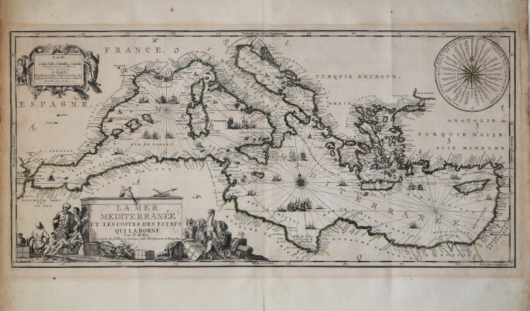
Etching, with fine old colour, very good condition.
Map taken from: Atlas ou Recueil de cartes geographiques Dressées Sur les Nouvelles Observations de Mrs de l’Academie Royale des Sciences Par N. de Fer, Geographe de sa Majesté Catolique et de Monseigneur le Dauphin. A Paris, chez l’Auteur dans l’Isle du Palais sur le Quay de l’Orloge a la Sphere Royale. Avec privilege du Roy 1709.
Title in the cartouche below right; imprint editorial in the cartouche at the top left, which also contains the metric scale: A Paris, Chez l'Auteur dans l'Isle du Palais sur le Quay de l'Orloge à a la Spere Royale. Avec Privilege du Roy. 1709. At the bottom right, the signature of the engraver Johannes van Loon.
Chart of the Mediterranean published in the "Atlas ou Recueil de cartes geographiques" of Nicolas de Fer, dedicated to Louis of France the "Grand Dauphine", heir to the throne of Louis XIV.
Bibliografia: Mare Nostrum, a historic voyage across the Mediterranean Sea, Lussemburgo, 2003, p. 40; M. Pastoureau, Les Atlas Francais XVIe-XVIIe siècles, Parigi, 1984, pp. 167-223, FER II A (77).
|
S. Bifolco, "Mare Nostrum, Cartografia nautica a stampa del Mar Mediterraneo" (2020), pp. 256-257, tav. 119.
|
Nicolas DE FER (1646-1720 circa)
|
One of the most prolific and influential French geographers and cartographers of the late 17th and early 18th Century. Nicolas was the youngest son of Parisian print and mapseller, Antoine de Fer [d.1673]. He produced numerous atlases: Atlas Curieux [1700-5] and its subsequent suites; Atlas ou Receuil des Cartes [1709]; Atlas Royale [1699]; Les Beautés de la France [1708]; Atlases detailing wars and countries relating to the Spanish succession [1701]; Italy [1702] & Germany [1705] and Franco-Belgian frontiers [1708-10]; Les Forces de L'Europe [1690-95]; Introduction à la Géographie [1708]; the Petit Nouveau Atlas [1697]. Aswell as his Atlas output de Fer is also well known for his large Wall maps, some 26 in total, aswell as large-scale town plans of European cities, and a signifcant output of thematic printed card games. His sign and emblem was the Sphère Royale, originally that of Melchior Tavernier, to which he was greatly attached and which appears on a large number of his works. He died on 25th October 1720 and his estate was divided between his three daughters, all three of whose husbands were closely involved in the Parisian engraving and publishing business : Guillaume Danet, Remi Richer, Jaques-Francois Besnard or Bénard. A number of de Fer's maps and atlases continued to be published by his heirs for another twenty or thirty years.
|
|
S. Bifolco, "Mare Nostrum, Cartografia nautica a stampa del Mar Mediterraneo" (2020), pp. 256-257, tav. 119.
|
Nicolas DE FER (1646-1720 circa)
|
One of the most prolific and influential French geographers and cartographers of the late 17th and early 18th Century. Nicolas was the youngest son of Parisian print and mapseller, Antoine de Fer [d.1673]. He produced numerous atlases: Atlas Curieux [1700-5] and its subsequent suites; Atlas ou Receuil des Cartes [1709]; Atlas Royale [1699]; Les Beautés de la France [1708]; Atlases detailing wars and countries relating to the Spanish succession [1701]; Italy [1702] & Germany [1705] and Franco-Belgian frontiers [1708-10]; Les Forces de L'Europe [1690-95]; Introduction à la Géographie [1708]; the Petit Nouveau Atlas [1697]. Aswell as his Atlas output de Fer is also well known for his large Wall maps, some 26 in total, aswell as large-scale town plans of European cities, and a signifcant output of thematic printed card games. His sign and emblem was the Sphère Royale, originally that of Melchior Tavernier, to which he was greatly attached and which appears on a large number of his works. He died on 25th October 1720 and his estate was divided between his three daughters, all three of whose husbands were closely involved in the Parisian engraving and publishing business : Guillaume Danet, Remi Richer, Jaques-Francois Besnard or Bénard. A number of de Fer's maps and atlases continued to be published by his heirs for another twenty or thirty years.
|