| Reference: | VR44EN |
| Author | MOUNT & PAGE |
| Year: | 1745 ca. |
| Zone: | Mediterranean Sea |
| Printed: | London |
| Measures: | 1280 x 580 mm |
| Reference: | VR44EN |
| Author | MOUNT & PAGE |
| Year: | 1745 ca. |
| Zone: | Mediterranean Sea |
| Printed: | London |
| Measures: | 1280 x 580 mm |
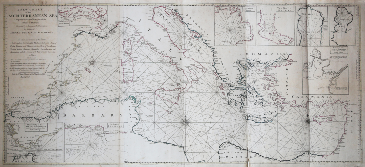
A New Chart of the Mediterranean Sea Composed from the Draughts of the Pilots of Marseilles Corrected by Astronomical Observations: By Order M. GR Le Comte de Maurepas. To which are annexed by the Editor A Draught of the Streight Mouth including the Bays of Cadism Gibraltar and Malaga: also Ports of Leghorne, Naples, Mahon, Smyrna, Salonichi, Scandaroon and Alexandria: with the Course of the Nile from the last place to Cairo.
Etching, printed on three sheets of laid paper and applied on a blue paper support, total dimensions 580x1280 mm. Signed with editorial imprint at the top left, under the title: Sold by William Mount & Tho.s Page Tower Hill. London.
Large map of the Mediterranean - on three sheets - based on the work of the Dépôt des cartes et plans de la Marine, printed in Paris in 1737 and engraved by Guillaume Dheulland, or, more probably, on the English copy published by John Senex in 1738. If l the French original, in fact, is the source of the nautical information, the version of Senex is the model for the nautical plans of the different harbours of the Mediterranean, perfectly replicated in this work.
The map is signed by William Mount and Thomas II Page, respectively son of Richard and Thomas I, first exponents of the typography who printed "The English Pilot" until the beginning of the nineteenth century.
The map belongs to the so-called "blueback charts" which began to appear in London in the second half of the 18th century; they were nautical charts of great or very large format, so named for their particular blue paper support. The media - a blue sheet commonly available and traditionally used by publishers to contain unblocked printed pamphlets - was adopted as a practical way to reinforce the low quality paper used by nautical charts publishers in an effort to reduce costs. The first known blueback cards are the ones published by Mount & Page typography around 1750 and later by Robert Sayer (1787).
Tradition took off in the early 19th century, when British publishers such as John Hamilton Moore, Robert Blachford, James Imray, William Heather, John William Norie, Charles Wilson, David Steel, RH Laurie and John Hobbs began to dominate the cartography trade boating. The bluebacks became so popular as to be adopted by the Americans Edmund March Blunt and George Eldridge, as well as by Scandinavian, French, German, Russian and Spanish cartographers. The blueback cards remained popular until the end of the 1800s, when government-subsidized organizations, such as the British Admiralty Hydrographic Office and the United States Coast Survey, began to publish their own nautical tables on high-quality paper that did not require reinforcements.
Bibliografia: cfr. S. Fisher, The Blueback Charts, in “The Map Collector” n. 31, Londra 1985, pp. 18-23; S. Fisher, The Makers of the Blueback Charts, History of Imray Laurie Norie & Wilson Ltd, Londra 2001; cfr. National Maritime Museum, Catalogue of the Library - Vol. Three, Atlas & Cartography, Londra, 1971, pp. 460-462; cfr. R. Shirley, Maps in the Atlases of the British Library, Londra, 2004, pp. 1236-1266; cfr. The Compleat Plattmaker: essays on Chart, Map and Globe Making in England in the Seventeenth and Eighteenth Centuries, Berkeley, 1978.
|
S. Bifolco, "Mare Nostrum, Cartografia nautica a stampa del Mar Mediterraneo" (2020), pp. 226-227, tav. 105.
|
|
The English Pilot was an important British sea-atlas published from 1671 to 1803. Initially published by John Seller, publication of the atlas changed hands periodically, with other publishers including Charles Price, John Thornton, and the Mount & Page firm. The charts from the English Pilot were intended as working charts so there was an effort to make them accurate, although predictably, many seamen complained that the charts were consistently out of date and that changes were slow to appear, a charge leveled at virtually every British, French and American Chart maker, including the respective governments of these nations. Ironically, it was in no small part due to the proprietary nature of the information included in the maps and sailing directions that there was a tendency for commercial pilots to pass the information from mariner to chart-maker more slowly than might otherwise have been the case, although the chart makers on the Thames and otherwise were undoubtedly reluctant to immediately make each and every necessary correction, for fear of undermining the economic viability of their businesses.
|
|
S. Bifolco, "Mare Nostrum, Cartografia nautica a stampa del Mar Mediterraneo" (2020), pp. 226-227, tav. 105.
|
|
The English Pilot was an important British sea-atlas published from 1671 to 1803. Initially published by John Seller, publication of the atlas changed hands periodically, with other publishers including Charles Price, John Thornton, and the Mount & Page firm. The charts from the English Pilot were intended as working charts so there was an effort to make them accurate, although predictably, many seamen complained that the charts were consistently out of date and that changes were slow to appear, a charge leveled at virtually every British, French and American Chart maker, including the respective governments of these nations. Ironically, it was in no small part due to the proprietary nature of the information included in the maps and sailing directions that there was a tendency for commercial pilots to pass the information from mariner to chart-maker more slowly than might otherwise have been the case, although the chart makers on the Thames and otherwise were undoubtedly reluctant to immediately make each and every necessary correction, for fear of undermining the economic viability of their businesses.
|