
| Reference: | VR36IT |
| Author | Vincenzo CORONELLI |
| Year: | 1688 ca. |
| Zone: | Mediterranean Sea |
| Printed: | Venice |
| Measures: | 1205 x 460 mm |
| Reference: | VR36IT |
| Author | Vincenzo CORONELLI |
| Year: | 1688 ca. |
| Zone: | Mediterranean Sea |
| Printed: | Venice |
| Measures: | 1205 x 460 mm |
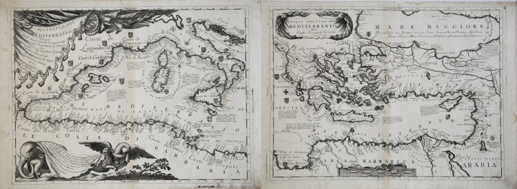
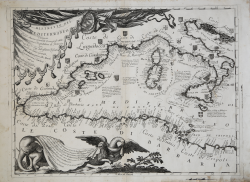
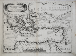
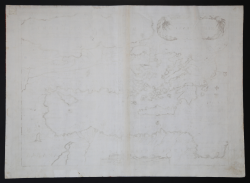
Ristretto del Mediterraneo, Composto Dal P. Maestro Coronelli Cosmografo della Serenissima Repubbica di Venezia per l’Ill.mo et Ecc.mo Sig. Sebastiano Foscarini Caualier, Sauio Grande, fù Ambasciatore alle Maestà Cristianissima, e Cattolica. ad uso Dell'Accademia Geografica degli Argonauti. Dedicato à Sua Eccell.za & Parte Orientale del Mediterraneo del Padre Cosmografo Coronelli. In Venezia con Privilegio dell’Ecc. Senato.
Map taken from: Atlante Veneto, Nel quale si contiene la Descrittione Geografica, Storica, Sacra, Profana, e Politica, Degl’Impery, Regni, Provincie, e Stati, Dell'Universo ... Accresciuto di molte Tavole Geografiche, non più publicate. Opera, e Studio Del Padre Maestro Coronelli Min: Convent ... Nell’ Universita di Venetia, Ad Uso Dell’Accademia Cosmografica de gli Argonauti. Tomo I. In Venetia MDCXCI.
Etching, printed on two sheets, some foxing, otherwise very good.
The map of the Mediterranean by Vincenzo Coronelli, although it does not have the typical characteristics of the nautical chart, is to be considered as such since it was built with the intention of representing only the coast, as confirmed by the toponymy, almost entirely non-existent inside.
The author himself calls them "Tavole Idrografiche" (Hydrographic Plates) in his notice to the reader, placed in the decorated cartouche at the bottom left.
The date of the work, which appears for the first time in the "Tome I" of the Veneto Atlas, is traced back to around 1688, on the basis of the fact that, with that date, Coronelli publishes the "Il Mediterraneo descritto", a collection of maps in part already existing, which can be closely related to this hydrographic map.
Bibliografia: E. Armao, Vincenzo Coronelli, Firenze 1944; A. de Ferrari, Vincenzo Coronelli, in “Dizionario Biografico degli Italiani”, Volume 29 (1983); cfr. D. Domini, M. Milanesi (a cura di), Vincenzo Coronelli e l’Imago mundi, Ravenna 1998; M. Fiorini, Sfere terrestri e celesti di autore ital. oppure fatte o conservate in Italia, Roma 1899, pp. 329-367; cfr. I. Liberale Gatti, Il P. Vincenzo Coronelli dei Frati minori conventuali negli anni del generalato (1701-1707), Università Gregoriana, Roma 1976; Mare Nostrum, a historic voyage across the Mediterranean Sea, Lussemburgo, 2003, p. 12.
|
S. Bifolco, "Mare Nostrum, Cartografia nautica a stampa del Mar Mediterraneo" (2020), pp. 48-49, tav. 13.
|
Vincenzo CORONELLI (Venezia 1650 - 1718)
|
Cosmographer, geographer, biographer, encyclopedist, globe maker, inventor, expert of engeneering and hydraulics. Extraordinarily versatile mind and an extremely tireless man, he produced more than 140 pieces in different genres. At the age of 15, he entered the Franciscan Order, which he then guided as Gran Generale from 1699. He became famous as geographer and mathematician, awakening the interest in these subjects in Italy at the end of the XVII century. He travelled a lot, seeking for all that was new, and keeping a correspondance with the most important intellectuals of his time. In 1681 Louis XIV wanted him to go to France, to entrust him with the task of making two terraqueous globes (Marly Globes), with a diameter of 4 metres. Once he came back to Italy, in 1685, he became Cosmographer of the Venetian Republic, where he taught geography and founded the first geographic accademy, called The Argonauts Accademy. In his whole life he produced more that 500 maps; some of them can be found in his most famous works, such as the Venetian Atlas (1690), the Island Book of the Venetian Atlas (1696-97), the Book of Globes (1693). As far as his scientific method, he didn’t elaborate new cartographic systems, but followed the theories that were considered most popular and effective at his time, based on the Copernican system. The main characteristic of his charts is the high quantity of toponymic and historical information. In his most famous and dense work, the Venetian Atlas, we can find about 1100 plates, 200 of which are extremely technical and this is the reason why it is considered the first Italian atlas to describe and illustrate the whole world with charts and maps. It was published in 13 volumes, starting from 1690, and it took nearly ten years to finish it. It is divided in different parts, the most important are the Atlas itself, then the Island Book, the Corso Geografico and the Teatro delle città.
|
|
S. Bifolco, "Mare Nostrum, Cartografia nautica a stampa del Mar Mediterraneo" (2020), pp. 48-49, tav. 13.
|
Vincenzo CORONELLI (Venezia 1650 - 1718)
|
Cosmographer, geographer, biographer, encyclopedist, globe maker, inventor, expert of engeneering and hydraulics. Extraordinarily versatile mind and an extremely tireless man, he produced more than 140 pieces in different genres. At the age of 15, he entered the Franciscan Order, which he then guided as Gran Generale from 1699. He became famous as geographer and mathematician, awakening the interest in these subjects in Italy at the end of the XVII century. He travelled a lot, seeking for all that was new, and keeping a correspondance with the most important intellectuals of his time. In 1681 Louis XIV wanted him to go to France, to entrust him with the task of making two terraqueous globes (Marly Globes), with a diameter of 4 metres. Once he came back to Italy, in 1685, he became Cosmographer of the Venetian Republic, where he taught geography and founded the first geographic accademy, called The Argonauts Accademy. In his whole life he produced more that 500 maps; some of them can be found in his most famous works, such as the Venetian Atlas (1690), the Island Book of the Venetian Atlas (1696-97), the Book of Globes (1693). As far as his scientific method, he didn’t elaborate new cartographic systems, but followed the theories that were considered most popular and effective at his time, based on the Copernican system. The main characteristic of his charts is the high quantity of toponymic and historical information. In his most famous and dense work, the Venetian Atlas, we can find about 1100 plates, 200 of which are extremely technical and this is the reason why it is considered the first Italian atlas to describe and illustrate the whole world with charts and maps. It was published in 13 volumes, starting from 1690, and it took nearly ten years to finish it. It is divided in different parts, the most important are the Atlas itself, then the Island Book, the Corso Geografico and the Teatro delle città.
|