| Reference: | VR13OL |
| Author | Huych ALLARD |
| Year: | 1680 ca. |
| Zone: | Europe |
| Printed: | Amsterdam |
| Measures: | 605 x 475 mm |
| Reference: | VR13OL |
| Author | Huych ALLARD |
| Year: | 1680 ca. |
| Zone: | Europe |
| Printed: | Amsterdam |
| Measures: | 605 x 475 mm |
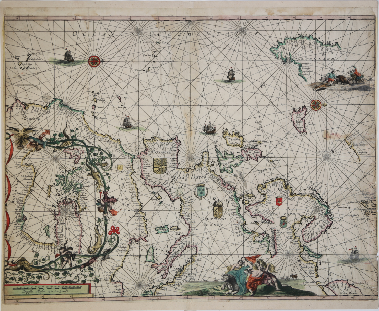
Etching and engraving, 475x605 mm, signed “Hugo Allart excudit “.
Magnificent example with wonderful old colors. Minimal restorations perfectly executed on the right side of the sheet, overall in excellent condition.
Not described by Koeman, this VERY RARE chart came for the Wardington collection, sold as part of the Atlas by Sotheby's London, 2005.
Not titled and dated, the mapi s based on the model of W. J. Blaeu of 1621, with the representation of the eastern Mediterranean within the African continent, in a curious floral cartouche.
The chart is probably referring round 1680 and is closely related to the work by Casparus Lootsman: there is, to the north of Iceland, the same unknown mass of land and inscriptions relating to a discoveries: t'Lant van Broer Ruys op gedaen Year 1655, Baay door Gael Hamkes opgedaen An ° 1654 and 't Lant van Edam opgedaen 1655.
The milestone scale, lower left, is in Dutch miles only.
Huych Allard (1625 - 1691) is the forefather of this family of map makers, publishers and printers. He probably began his publishing career in 1645; in 1684 it is active in Amsterdam, in "Calverstraet bij den Dam". His activity takes place concurrently with that of the great producers of maps of the time such as the Blaeu and the Hondius-Janssonius.
His cartographic production is scarce and the success of the typography will only come later with his son Carel. The works of Huych Allard - who also signed himself as Hugo Allaert and Allardt - are therefore very rare today; Koeman only records a composite atlas at the British Library and one at the University Library of Leiden. Another well-known collection is that belonging to the collection of Lord Wardington, sold at auction by Sotheby's in 2005. Huych died in 1691, leaving his shop in the hands of his son, Carel Allard.
Bibliografia: C. Koeman, Atlantes Neerlandici: Bibliography of Terrestrial, Maritime and Celestial Atlases and Pilot Books Published in the Netherlands up to 1880 Vol. I, Amsterdam 1967, pp. 31-48; Sotheby’s, The Wardington Library. Important Atlases & Geographies, Londra, 18 october 2005, pp. 28-31, n. 6, ill. p. 28.
|
S. Bifolco, "Mare Nostrum, Cartografia nautica a stampa del Mar Mediterraneo" (2020), pp. 150-151, tav. 63.
|
|
The Allard family ran an active publishing business in Amsterdam in the latter half of the seventeenth century.
Most of their publications consisted of atlases made up of maps and town plans by their more famous predecessors, Blaeu, Jansson, de Wit, Visscher and others, but one of their most attractive and interesting sheet maps was of New England (Hugo Allard, 1656), based on Jansson, which included a view of New Amsterdam by C. J. Visscher.
|
|
S. Bifolco, "Mare Nostrum, Cartografia nautica a stampa del Mar Mediterraneo" (2020), pp. 150-151, tav. 63.
|
|
The Allard family ran an active publishing business in Amsterdam in the latter half of the seventeenth century.
Most of their publications consisted of atlases made up of maps and town plans by their more famous predecessors, Blaeu, Jansson, de Wit, Visscher and others, but one of their most attractive and interesting sheet maps was of New England (Hugo Allard, 1656), based on Jansson, which included a view of New Amsterdam by C. J. Visscher.
|