
| Reference: | 4042 |
| Author | Charles PRICE |
| Year: | 1730 ca. |
| Zone: | Mediterranean sea |
| Printed: | London |
| Measures: | 1180 x 480 mm |
| Reference: | 4042 |
| Author | Charles PRICE |
| Year: | 1730 ca. |
| Zone: | Mediterranean sea |
| Printed: | London |
| Measures: | 1180 x 480 mm |
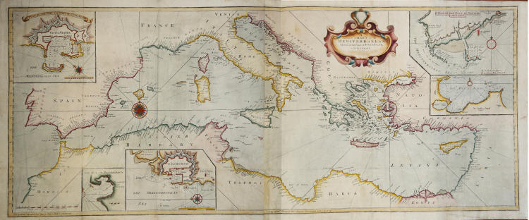
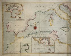
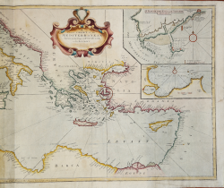
Great sea chart of the Mediterranean sea, decorated with cartouches depicting the plans of the harbours of Civitavecchia, Livorno, Nettuno and the bays of Tunis and Scanderoon.
The map, which has been realized by Thornton, was published in the English Pilot, a monumental collection of sea charts realized by different authors, mainly English, published by Mount & Page between 1738 and 1787.
Copper engraving, printed on two sheets afterwards joined together, fine hand colour, light oxidations on lower part otherwise in excellent condition.
Rare.
|
S. Bifolco, "Mare Nostrum, Cartografia nautica a stampa del Mar Mediterraneo" (2020), pp. 218-219, tav. 100.
|
Charles PRICE (circa 1679 - 1733)
|
Charles Price was an engraver, instrument maker, and mapseller. Price had been apprenticed to John Seller, famous mapmaker and father to Charles’ business partner, Jeremiah. In fact, Jeremiah and Charles were made free of the Merchant Taylors Guild on the same day, September 1, 1703. The two were already working together by then. After breaking off with Seller, Price worked with John Senex (1705-10) and George Wildey (1710-13). He was still working in the 1720s, but was in Fleet Prison in 1731 for debt and died two years later. He is known to have published in 1732 his Atlas Maritimus or, a new Sea Atlas . . . This work contains maps dated 1728 and 1731. We locate at single example (Bancroft Library - 30 maps) and we acquired an example in 2018 (25 maps). It is quite likely that the work was an unfinished composite, as a number of the maps have blank spaces in the titles, in anticipation of dedicatees that were apparently never obtained. The atlas was known to have been started, but not completed, as noted by Tony Campbell in the British Library Journal, recording the acquisition by the British Library of an untitled collection of charts by Price.
|
|
S. Bifolco, "Mare Nostrum, Cartografia nautica a stampa del Mar Mediterraneo" (2020), pp. 218-219, tav. 100.
|
Charles PRICE (circa 1679 - 1733)
|
Charles Price was an engraver, instrument maker, and mapseller. Price had been apprenticed to John Seller, famous mapmaker and father to Charles’ business partner, Jeremiah. In fact, Jeremiah and Charles were made free of the Merchant Taylors Guild on the same day, September 1, 1703. The two were already working together by then. After breaking off with Seller, Price worked with John Senex (1705-10) and George Wildey (1710-13). He was still working in the 1720s, but was in Fleet Prison in 1731 for debt and died two years later. He is known to have published in 1732 his Atlas Maritimus or, a new Sea Atlas . . . This work contains maps dated 1728 and 1731. We locate at single example (Bancroft Library - 30 maps) and we acquired an example in 2018 (25 maps). It is quite likely that the work was an unfinished composite, as a number of the maps have blank spaces in the titles, in anticipation of dedicatees that were apparently never obtained. The atlas was known to have been started, but not completed, as noted by Tony Campbell in the British Library Journal, recording the acquisition by the British Library of an untitled collection of charts by Price.
|