
| Reference: | A52985 |
| Author | Henri Abraham CHATELAIN |
| Year: | 1708 ca. |
| Zone: | Rome |
| Printed: | Amsterdam |
| Measures: | 445 x 340 mm |
| Reference: | A52985 |
| Author | Henri Abraham CHATELAIN |
| Year: | 1708 ca. |
| Zone: | Rome |
| Printed: | Amsterdam |
| Measures: | 445 x 340 mm |
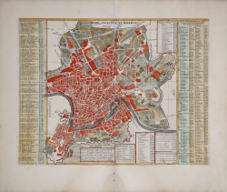
Vertical projection map of Rome, oriented with the north on the left.
This very schematic plan derives as a basis of representation from the large map of Falda and not from that of De Rossi as claimed in the past by Huelsen. It depicts Rome around 1700: in fact, not only the Spanish Steps are missing, made between 1721 and 1725 as noted by Scaccia Scarafoni, but also the port of Ripetta made in 1704 and the interventions due to Innocenzo XII, but the poor definition of the drawing does not allow to verify with certainty. The built lots do not have a field but a dense series of 320 numbers and various letters that refer to the legend placed on the two sides of the plan. It is instead represented with greater care the design of gardens and villas (cf. Marigliani p. 255).
Taken from "Atlas Historique" , this sheet includes a small map of the northern hemisphere including all of Europe and Asia and most of Africa, above the horn.
Henri Abraham Chatelain (1684 - 1743) was a Huguenot pastor of Parisian origins. He is best known as a Dutch cartographer and more specifically for his cartographic contribution in the seminal seven volume Atlas Historique, published in Amsterdam between 1705 and 1720. Innovative for its time, the Atlas Historique combined fine engraving and artwork with scholarly studies of geography, history, ethnology, heraldry, and cosmography. Some scholarship suggests that the Atlas Historique was not exclusively compiled by Henri Chatelain, as is commonly believed, but rather was a family enterprise involving Henri, his father Zacharie and his brother, also Zacharie.
Copper engraving, with fine later hand colour, in excellent condition.
Literature
Huelsen (1915): n. 129b; Scaccia Scarafoni (1939): n. 219; Marigliani (2007): p. 255, n. 162.
Henri Abraham CHATELAIN (1684 - 1743)
|
Henri Abraham Chatelain (1684 - 1743) was a Huguenot pastor of Parisian origins. He is best known as a Dutch cartographer and more specifically for his cartographic contribution in the seminal seven volume Atlas Historique, published in Amsterdam between 1705 and 1720. Innovative for its time, the Atlas Historique combined fine engraving and artwork with scholarly studies of geography, history, ethnology, heraldry, and cosmography. Some scholarship suggests that the Atlas Historique was not exclusively compiled by Henri Chatelain, as is commonly believed, but rather was a family enterprise involving Henri, his father Zacharie and his brother, also Zacharie. The Atlas Historique published by Chatelain was part of a major work of its time, an encyclopaedia in seven volumes including geography as one of its main subjectes. The text was by Nicholas Gueudeville and the maps by Chatelain. The Atlas included one of the finest maps of America (4 sheets) surrounded by vignettes and decorative insets.
1705-20 Atlas Historique:Amsterdam (maps by Chatelain based on G.Delisle)
Further issues to 1739
|