
| Reference: | A53992 |
| Author | Adolphe Hippolyte DUFOUR |
| Year: | 1840 ca. |
| Zone: | Rome |
| Printed: | Paris |
| Measures: | 275 x 225 mm |
| Reference: | A53992 |
| Author | Adolphe Hippolyte DUFOUR |
| Year: | 1840 ca. |
| Zone: | Rome |
| Printed: | Paris |
| Measures: | 275 x 225 mm |
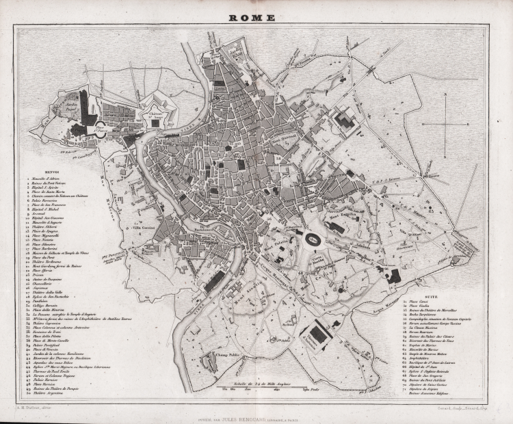
Map of Rome published by the Parisian publisher Jules Renouard around 1840, based on the works of Adolphe Hippolyte Dufour and engraved by Bernard Gavard. This detailed plan depicts the city before its expansion as the capital of Italy, with its historic walled boundaries, main districts, and monumental landmarks. It features a rich legend (divided into "Renvois" and "Suite") listing squares, palaces, churches, and ancient ruins.
“A sinistra in basso Dugour A. H. direx. Leganda di 71 numeri, edifici in legenda campiti più scuri con tratteggio incrociato” (cfr. Marigliani, p. 349).
Etching, in good condition.
Bibliografia
C. Marigliani, Le piante di Roma nelle collezioni private, p. 349, n. 281.
Adolphe Hippolyte DUFOUR (Parigi 1795 - 1865)
|
Adolphe Hippolyte Dufour (1798 - 1865), also known as Auguste-Henri Dufour, was a Paris based map and atlas publisher active in the mid to late 19th century. Dufour claimed to be a student of another French cartographer, Emile Lapie. His is known to have worked with numerous other cartographers, publishers and engravers of the period including Dyonnet and Duvotenay. In 1824, he first published a geographical analysis of the map of Palestine under his own name, and from then on took part in a series of historical and topographical publications for which he prepared and drew plans and maps. His corpus includes numerous maps and atlases, the most striking of which is probably his monumental 1857 elephant folio Grand atlas Universel physique, historique et politique geographie ancienne et moderne. His main works are: L'atlas élémentaire et universel de géographie ancienne et moderne (1828); Plusieurs Précis de système planétaire et de cosmographie; L'atlas joint à la France illustrée de Victor Adolphe Malte-Brun (1855); L'atlas Dufour, atlas universel, physique, historique et politique de la France, de ses départements et de ses colonies (1857).
|
Adolphe Hippolyte DUFOUR (Parigi 1795 - 1865)
|
Adolphe Hippolyte Dufour (1798 - 1865), also known as Auguste-Henri Dufour, was a Paris based map and atlas publisher active in the mid to late 19th century. Dufour claimed to be a student of another French cartographer, Emile Lapie. His is known to have worked with numerous other cartographers, publishers and engravers of the period including Dyonnet and Duvotenay. In 1824, he first published a geographical analysis of the map of Palestine under his own name, and from then on took part in a series of historical and topographical publications for which he prepared and drew plans and maps. His corpus includes numerous maps and atlases, the most striking of which is probably his monumental 1857 elephant folio Grand atlas Universel physique, historique et politique geographie ancienne et moderne. His main works are: L'atlas élémentaire et universel de géographie ancienne et moderne (1828); Plusieurs Précis de système planétaire et de cosmographie; L'atlas joint à la France illustrée de Victor Adolphe Malte-Brun (1855); L'atlas Dufour, atlas universel, physique, historique et politique de la France, de ses départements et de ses colonies (1857).
|