
| Reference: | S51142 |
| Author | Theodor ETTLING |
| Year: | 1860 ca. |
| Zone: | Rome |
| Printed: | London |
| Measures: | 430 x 310 mm |
| Reference: | S51142 |
| Author | Theodor ETTLING |
| Year: | 1860 ca. |
| Zone: | Rome |
| Printed: | London |
| Measures: | 430 x 310 mm |
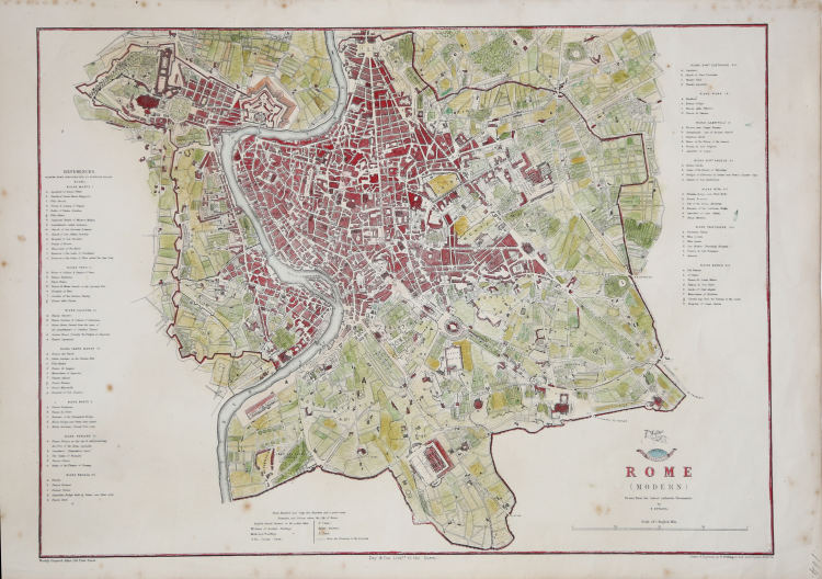
Detailed map of Rome drawn and engraved by T. Ettling for the Weekly Dispatch Atlas. Published London 1863.
‘The Weekly Dispatch’ was published between the years 1801 and 1928, but from 1856 to 1862 each edition included a map of a part of the world. Those of England were derived from the Ordnance Survey. The engravers varied but included John Dower and Edward Weller. ‘The Dispatch Atlas’ was published in 1863 which contained the complete series of maps published to date, including the set of English county maps. It could be ordered in one, two or three volumes. This was so that it could be divided geographically if desired.
Theodor ETTLING (nato circa nel 1823 in Germania)
|
Born in about 1823 in Germany, Theodore Ettling practised as an engraver, draughtsman and lithographer in Amsterdam before moving to London in about 1850. He specialised in maps of the Americas, including some noteworthy maps of the United States during the Civil War. We stock the maps for which he is best known - those which he contributed to Cassells Weekly "Dispatch Atlas" (1858-1863) - which covered North America, South America, the Balkans, and city plans of Venice and Rome. His work also included maps for the Drawing Room Atlas of Europe (1855), maps of the United States for the Illustrated London News (1861), and the Times Map of North America (1861).
|