| Reference: | CO-091 |
| Author | Barent LANGENES |
| Year: | 1599 |
| Zone: | Malta |
| Printed: | Amsterdam |
| Measures: | 125 x 90 mm |
| Reference: | CO-091 |
| Author | Barent LANGENES |
| Year: | 1599 |
| Zone: | Malta |
| Printed: | Amsterdam |
| Measures: | 125 x 90 mm |
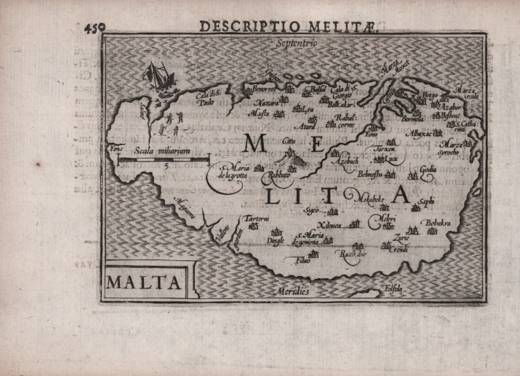
Rara carta geografica per la prima volta pubblicata nel "Caert-thresoor" di Barent Langenes edito ad Amstredam da Cornelis Claesz nel 1598. Esemplare dalla successiva ristampa con testo latino del 1599.
Alla fine del XVI secolo il più famoso e commercializzato atlante “tascabile” era l’Epitome di Abraham Ortelius. Nel 1598 gli editori Barent Langenes e Cornelis Claesz diedero alle stampe una raccolta di superiore qualità. Le lastre sono affidate ad abili intagliatori quali Pieter Kaerius e Jodocus Hondius.
Acquaforte, leggera gora d'acqua in basso a destra, per il resto in ottimo stato di conservazione.
Bibliografia
King, Miniature Antique Maps, pp. 80-82.
Barent LANGENES (Attivo nella seconda metà del XVI sec.)
|
Dutch publisher and engraver of Middelburg, he is renowned for his miniature atlases, which can be considered as a model for the following corresponding atlases. His most famous work has been published in Middelburg inl 1598, the "Caert Thresoor". The maps have been engraved by Pieter van den Keere and Jodocus Hondius and have been used for various translations and for Bertius' Tabularum Geographicarum.
|