
| Reference: | S10089 |
| Author | Istituto Idrografico della Marina |
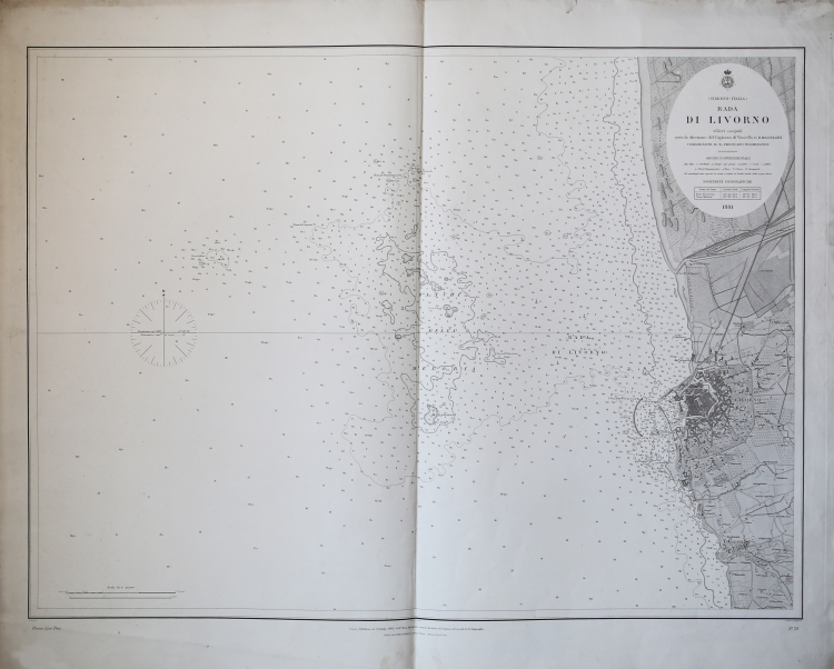
| Year: | 1881 ca. |
| Zone: | Livorno |
| Printed: | Genua |
| Measures: | 870 x 700 mm |
| Reference: | S10089 |
| Author | Istituto Idrografico della Marina |
| Year: | 1881 ca. |
| Zone: | Livorno |
| Printed: | Genua |
| Measures: | 870 x 700 mm |
The history of the Istituto Idrografico della Marina began a few years after the national unification with the creation in Livorno, in 1875, of the Ufficio Centrale per il Servizio Scientifico della Regia Marina, which should have depended on Departmental Offices heirs of the functions of cartographic processing of pre-unitary institutions. It was instead created only the Ufficio Dipartimentale di Genova, at Forte San Giorgio, which in turn left the place, in 1872, by the national mapping body called Ufficio Idrografico della Regia Marina. In 1899 this name was changed to the current name of Istituto Idrografico della Marina.
The institute was founded by royal decree on 26 December 1872 and at its head was called the frigate captain, mathematician and hydrographer Giovan Battista Magnaghi, with the task of performing the hydrographic survey of the Italian seas and to produce the national nautical documentation. After the war, in addition to reconnaissance to update the nautical charts, a new coastal triangulation network was created.
Engraving on zinc, with margins, in good condition.
Bibliografia
Amedeo Benedetti, L'Istituto Idrografico della Marina, in Charta Geographica, 93, ottobre 2007, pp. 12–13; Paola Presciuttini, L'Istituto Idrografico della Marina in Forte San Giorgio, Genova, I.I.M., 1995.
Istituto Idrografico della Marina
|
The history of the Istituto Idrografico della Marina began a few years after the national unification with the creation in Livorno, in 1875, of the Ufficio Centrale per il Servizio Scientifico della Regia Marina, which should have depended on Departmental Offices heirs of the functions of cartographic processing of pre-unitary institutions. It was instead created only the Ufficio Dipartimentale di Genova, at Forte San Giorgio, which in turn left the place, in 1872, by the national mapping body called Ufficio Idrografico della Regia Marina. In 1899 this name was changed to the current name of Istituto Idrografico della Marina.
The institute was founded by royal decree on 26 December 1872 and at its head was called the frigate captain, mathematician and hydrographer Giovan Battista Magnaghi, with the task of performing the hydrographic survey of the Italian seas and to produce the national nautical documentation. After the war, in addition to reconnaissance to update the nautical charts, a new coastal triangulation network was created.
|