
| Reference: | S43055 |
| Author | Jacques Nicolas BELLIN |
| Year: | 1764 ca. |
| Zone: | La Spezia |
| Printed: | Paris |
| Measures: | 185 x 230 mm |
| Reference: | S43055 |
| Author | Jacques Nicolas BELLIN |
| Year: | 1764 ca. |
| Zone: | La Spezia |
| Printed: | Paris |
| Measures: | 185 x 230 mm |
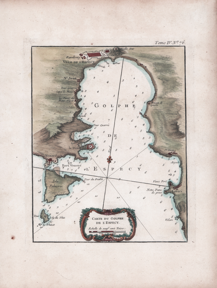
Nautical chart of the Gulf of La Spezia, from Porto Venere to Lerici and with the island of Palmaria.
Map taken from: Le Petit Atlas Maritime Recueil De Cartes et Plans Des Quatre Parties Du Monde. en Cinq Volumes. I. Volume. Amerique Septentrionale et Isles Antilles. II. Volume. Amerique Meridionale. Mexique, Terra-Ferme, Bresil, Perou, Chily. III. Volume. Asia et Afrique. IV. Et V. Volumes. Europe et les Etats Qu'elle contient. Par Ordre de M. Le Duc de Choiseul, Colonel General des Suisses et Grisons Ministre de la Guerre et de la Marine. Par le S. Bellin Ingenieur de la Marine 1764.
Etching, magnificent original colouring, in excellent condition.
Small chart of the Mediterranean Sea, without date and signature. Coming from the fourth volume of "Le Petit Atlas Maritime", a wonderful pilot book from around the world of medium-small format, intended more for educational than for practical use.
Bellin was an important map-maker for the Dépôt des cartes et plans de la Marine. The "Neptune Francais" was published in 1753 and the "Hydrographie Francaise" in 1756. His greatest and most complete Atlas is "Le Petit Atlas Maritime", a work in 5 volumes illustrated by 581 maps, covering the coasts and important port cities of the known world; it is probably the best collection of plans of maritime cities and ports of his time.
According to Tooley, Bellin published an earlier version of this atlas in 1763 entitled "Petit Atlas Francois".
The Duc de Choiseul provided financial support for the publication that earned him the dedication. Étienne François de Choiseul (Nancy, June 28th 1719 - Chanteloup Castle, May 8th 1785) was a French diplomat and politician, former ambassador to Rome and then foreign minister in 1758, during the Seven Years' War.
J. Arrivet is listed as an engraver on the pages of the index and atlas titles, and it is not excluded that it may have also engraved the maps too.
Bibliografia
National Maritime Museum, Catalogue of the Library - Vol. Three, Atlas & Cartography, Londra, 1971, pp. 236-238; R. Shirley, Maps in the Atlases of the British Library, Londra, 2004, pp. 1071-1072, M.BELL-5a
Jacques Nicolas BELLIN (1703 - 1772)
|
Jacques-Nicolas Bellin (1703 - 1772) was one of the most important cartographers of the 18th century.
With a career spanning some 50 years, Bellin is best understood as transitional mapmaker spanning the gap
between 18th and early 19th century cartographic styles. His long career as Hydrographer and Ingénieur
Hydrographe at the French Dépôt des cartes et plans de la Marine resulted in hundreds of high quality
nautical charts of practically everywhere in the world. Bellin's work focuses on function and accuracy
tending in the process to be less decorative than the earlier 17th and 18th century cartographic work. In
addition to numerous maps and charts published during his lifetime, many of Bellin's maps were updated
(or not) and published posthumously. He was succeeded as Ingénieur Hydrographe by his student, also a prolific and influential cartographer, Rigobert Bonne.
|