
| Reference: | S42711 |
| Author | Antonio ZATTA |
| Year: | 1794 |
| Zone: | Liguria |
| Printed: | Venice |
| Measures: | 430 x 327 mm |
| Reference: | S42711 |
| Author | Antonio ZATTA |
| Year: | 1794 |
| Zone: | Liguria |
| Printed: | Venice |
| Measures: | 430 x 327 mm |
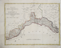
Rare variant - without the cartouche in the upper left corner and with the date 1794 - of the map published in the Atlante novissimo, illustrato ed accresciuto sulle osservazioni e scoperte fatte dai più celebri e più recenti geografi that shows the date 1782 inside the cartouche with the title placed in the upper left corner. The map is made from the same plate, abraded in the upper left, where there is also a new title.
The map is taken from Geografia storico politica d'Italia, a work in 6 volumes published in 1795 and enriched by some maps of the Atlante Novissimo, duly modified in date.
The Atlante Novissimo, as also specified in the title, is “increased on the observations made by the most famous and most recent geographers”. Among the most significant innovations there is the appearance of the new islands discovered in the Pacific Ocean by James Cook and the first Italian map of New Zealand. The illustrations were designed and drawn by his collaborators Giovanni Marco Pitteri, Anton Friedrich Busching, Pietro Antonio Novelli and engraved by Giuliano Zuliani.
The first volume of the atlas is introduced by a brief essay of general geography where the author defines in a concise and precise way the elements that make up the ecliptic and equatorial grids used in the tables. Interesting is the section where he pauses to describe the phenomenon of precession of the equinoxes and the cyclical variation of the obliquity of the ecliptic.
Etching, printed on contemporary laid paper, contemporary outline coloring, in good condition.
Antonio ZATTA (Venezia 1722 - 1804)
|
Antonio Zatta (1775-1797) was the most prominent Italian map publisher of the late 18th and early 19th century. His firm, based in Venice, produced maps that mark an important transition from 18th to 19th century cartographic styles. He updates and redefines the traditional title cartouche by replacing the mythic elements common to the 17th and 18th century with more representative images of Venice. His most important work is the four volume Atlante novissimo published from 1775 to 1789.
|