| Reference: | mms2401 |
| Author | Donnus Nicolaus GERMANUS |
| Year: | 1482 ca. |
| Zone: | Italy |
| Printed: | Ulm |
| Measures: | 550 x 365 mm |
| Reference: | mms2401 |
| Author | Donnus Nicolaus GERMANUS |
| Year: | 1482 ca. |
| Zone: | Italy |
| Printed: | Ulm |
| Measures: | 550 x 365 mm |
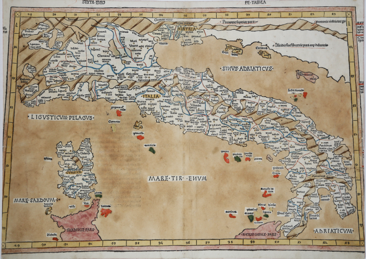
Woodcut, 1482. Magnificent proof, printed on contemporary laid paper, in beautiful contemporary colouring, minimal restoration at center fold perfectly executed, otherwise in excellent condition. The map is cut at the left side, as illustrated.
Very rare map on trapezoid projections, from the edition of 1486 of the Geographia of Ulm.
Donnus Nicolaus Germanus was a cartographer of German origin active in Florence in the second half of the fifteenth century. Its origins are unknown, but the name Donnus, short for Dominus, suggests that it is probably a Benedictine native of Reichenbach. A pioneer in cartography, he devoted himself to the study of the Latin translation of Ptolemy's Geographia curated by Jacopo Angelo. In 1466 Germanus (Nicolaus Laurentii), who worked in Florence as cosmographer, appeared in a vision to Duke of Ferrara Borso d'Este, the manuscript of a Geographia. In 1468 Nicolaus produced his third edition of the Geographia, this time moving to the north of Scandinavia, Greenland and Iceland in the North West, at the same latitude. Starting from the maps of this third version of Nicolaus, were made the printed editions of the Geographia of Ulm in 1482 and 1486.
This is the first editions printed outside Italy. The work contains 32 maps, of which five are not derived from the Ptolemaic, all made, unlike the Italian versions, in woodcut. The woodcuts are by Johannes Schnitzer of Arnheim. The work is considered as the most elaborate and important edition of the Geographia, because for the first time were added some maps of recent construction, which served as a comparison with the Ptolemaic. The next reprint of 1486, was published by Reger, who acquired the matrices in 1484 by Holle. The plates were reprinted without material changes; the only change is the text on the reverse of the map (where the decoration is omitted) and the title of each, added to the top of the map. The edition of Reger for the first time introduces the Registrum alphabeticum and De locis et mirabili bus mundi, which will become popular enough to be included in subsequent editions of Ptolemy to Rome in 1490 and 1507/8.
A magnific example.
|
R. Borri "L'Italia nelle antiche carte…" (2011), scheda 6; Almagià 6b, Perini p. 20.
|
Donnus Nicolaus GERMANUS (? - ante 1490)
|
Donnus Nicolaus Germanus is a path breaking cartographer of the medieval maps. One of the most important reasons for the popularity of Donnus Nicolaus is his Cosmographia, which is the first work of its kind. He also created two globes, which give a vivid description of the earth and the sky. The globes were created by him in the year 1477. These two globes predated the 'Erdapfel' by Martin Behaim. The two globes created by Donnus Nicolaus Germanus were preserved in Salle Pontifica or Magna Secreta, but they were lost in the Sacco di Roma in the year 1527. At the time of production of the globes, Donnus Nicolaus invented the 'Donis' map projection. In this map projection, the parallels of latitude are kept equidistant, while the meridians are made to converge towards both the poles.
|
|
R. Borri "L'Italia nelle antiche carte…" (2011), scheda 6; Almagià 6b, Perini p. 20.
|
Donnus Nicolaus GERMANUS (? - ante 1490)
|
Donnus Nicolaus Germanus is a path breaking cartographer of the medieval maps. One of the most important reasons for the popularity of Donnus Nicolaus is his Cosmographia, which is the first work of its kind. He also created two globes, which give a vivid description of the earth and the sky. The globes were created by him in the year 1477. These two globes predated the 'Erdapfel' by Martin Behaim. The two globes created by Donnus Nicolaus Germanus were preserved in Salle Pontifica or Magna Secreta, but they were lost in the Sacco di Roma in the year 1527. At the time of production of the globes, Donnus Nicolaus invented the 'Donis' map projection. In this map projection, the parallels of latitude are kept equidistant, while the meridians are made to converge towards both the poles.
|