| Reference: | A49975 |
| Author | Nicolas DE FER |
| Year: | 1760 ca. |
| Zone: | Italy |
| Printed: | Paris |
| Measures: | 610 x 460 mm |
| Reference: | A49975 |
| Author | Nicolas DE FER |
| Year: | 1760 ca. |
| Zone: | Italy |
| Printed: | Paris |
| Measures: | 610 x 460 mm |
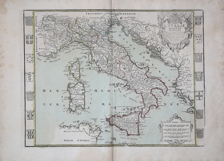
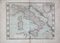
Map depicting Italy, embellished on both sides with the coats of arms of its main constituent states.
At the top right is the title within a rich cartouche, signed by Louis Desnos.
The map was first printed in Paris in 1707, signed by Nicolas De Fer and engraved by Peter Starckman, then included in De Fer's "Atlas Curieux où le Monde représenté dans les cartes générales et particulières du Ciel et de la Terre".
This copy, with Louis Desnos' address, differs in that the cartouche at the bottom left is missing and some small plate corrections are noted in the title cartouche.
Nicolas de Fer (1646-1720) was one of the greatest cartographers, engravers and publishers of the 17th century. His father, Antoine de Fer, was a modest print merchant working on the Ile del la Cité in Paris; he collaborated with Nicolas I Berey, then with Melchior Tavernier, and then with Jacques Lagnet. In 1652 Antoine adopted the "Sphére royale" trade sign, which had already belonged to Tavernier; in 1657 he printed Cartes de géographie, a small pocket collection by Pierre Duval. In 1667 he signed himself "merchand de cartes Gèographique"; he continued the business until 1686, when he left the print shop in the hands of his son Nicolas, who had been apprenticed to Parisian engraver Louis Spirinx and had already made his first map of the Canal du Midi, at the age of only 23. In 1689 he made a map of Franche-Comté to honor the Grand Dauphine - Louis of France (1661-1711), eldest son and heir of King Louis XIV of France, who was engaged in commanding a campaign to conquer new territories on the Rhine. He was later appointed official geographer of the Dauphiné, and his output was closely linked to the interests of the French crown: for example, Forces De L'Europe Ou Introduction A La Fortification, published in 1695, which showed the new fortifications designed by the innovative French engineer Sébastien de Vauban. He was also the official geographer of Philip V and Louis XIV (both the French and Spanish branches of the House of Bourbon) and finally, in 1720, of the Pope. De Fer published theAtlas curieux où le Monde représenté dans les cartes générales et particulièrs du Ciel et de la Terre between 1700 and 1705, adding new geographical plates each time. His most majestic work remains the Atlas Royal, dans l'Isle du Palais sur le Quay de l'Orloge a la Sphere royale (1693). Upon his death, the business was inherited by his son-in-law Guillaume Danet, who later joined forces with Jacques-François Benard.
Louis Charles Desnos was an 18th century French geographer, born in 1725, died on April 18, 1805. He was also a bookseller and publisher in Paris, where, as "ingénieur géographe pour les globes et les sphères de Sa Majesté Danoise", he had a store in rue Saint-Jacques, with the sign "Le Globe".
A geographical engineer (from the city of Paris since 1769), builder and dealer of spheres and astronomical instruments, he was an important manufacturer of cartographic instruments and globes. Desnos also held the coveted position of "Royal Globemaker" for the King of Denmark, Christian VII. In return, every year he sent the King maps, books and atlases. As a bookseller and publisher he produced a considerable amount of work, often associated with geographers Rizzi Zannoni and Louis Brion de la Tour (1756-1823). His great production of maps sometimes earned him a bad reputation among his jealous detractors and especially among other cartographers. He was considered unscrupulous because he used to publish whatever was presented to him, regardless of accuracy or copyright. Desnos had, therefore, several legal issues with other Parisian cartographers and publishers of the time.
Nicolas DE FER (1646-1720 circa)
|
One of the most prolific and influential French geographers and cartographers of the late 17th and early 18th Century. Nicolas was the youngest son of Parisian print and mapseller, Antoine de Fer [d.1673]. He produced numerous atlases: Atlas Curieux [1700-5] and its subsequent suites; Atlas ou Receuil des Cartes [1709]; Atlas Royale [1699]; Les Beautés de la France [1708]; Atlases detailing wars and countries relating to the Spanish succession [1701]; Italy [1702] & Germany [1705] and Franco-Belgian frontiers [1708-10]; Les Forces de L'Europe [1690-95]; Introduction à la Géographie [1708]; the Petit Nouveau Atlas [1697]. Aswell as his Atlas output de Fer is also well known for his large Wall maps, some 26 in total, aswell as large-scale town plans of European cities, and a signifcant output of thematic printed card games. His sign and emblem was the Sphère Royale, originally that of Melchior Tavernier, to which he was greatly attached and which appears on a large number of his works. He died on 25th October 1720 and his estate was divided between his three daughters, all three of whose husbands were closely involved in the Parisian engraving and publishing business : Guillaume Danet, Remi Richer, Jaques-Francois Besnard or Bénard. A number of de Fer's maps and atlases continued to be published by his heirs for another twenty or thirty years.
|