
| Reference: | S52988 |
| Author | Henrick SCHERER |
| Year: | 1702 |
| Zone: | Italy |
| Printed: | Munich |
| Measures: | 355 x 230 mm |
| Reference: | S52988 |
| Author | Henrick SCHERER |
| Year: | 1702 |
| Zone: | Italy |
| Printed: | Munich |
| Measures: | 355 x 230 mm |
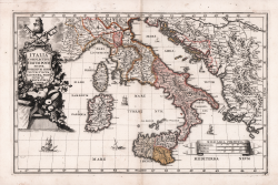
Decorativa carta geografica pubblicata nell'opera di Heinrich Scherer Atlas Novus exhibens orbem terraguem per naturae opera, historiae navae acveterus monumenta, artistique geographicae leges et praecepta edita in 8 parti, stampate tra il 1702 e il 1710 a Monaco di Baviera.
Heinrich Scherer, professore di matematica a Monaco di Baviera, era un gesuita devoto la cui opera sottolineava la gerarchia cattolica e la diffusione delle missioni gesuite in tutto il mondo. Il suo Atlas Novus contiene mappe di tutte le altre parti che mostravano la diffusione del cattolicesimo e delle missioni gesuite.
Acquaforte, finemente colorata in epoca, in ottimo stato di conservazione.
Henrick SCHERER (Dilingen 1628 - Monaco 1704)
|
Heinrich Scherer was a devout Jesuit, and professor of mathematics at Munich. His 'Atlas Novus' contained maps of all other parts which showed the spread of Catholicism and Jesuit missions.
|
Henrick SCHERER (Dilingen 1628 - Monaco 1704)
|
Heinrich Scherer was a devout Jesuit, and professor of mathematics at Munich. His 'Atlas Novus' contained maps of all other parts which showed the spread of Catholicism and Jesuit missions.
|