
| Reference: | S48052 |
| Author | Istituito Geografico WEIMAR |
| Year: | 1808 |
| Zone: | Italy |
| Printed: | Weimar |
| Measures: | 310 x 435 mm |
| Reference: | S48052 |
| Author | Istituito Geografico WEIMAR |
| Year: | 1808 |
| Zone: | Italy |
| Printed: | Weimar |
| Measures: | 310 x 435 mm |
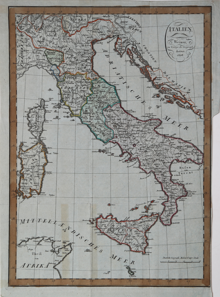
Map of Italy by August Ferdinand Götze, published in Weimar by the Geographische Institut in 1808.
The map was published as a result of the publishing project of Friedrich Justin Bertuch (1747-1822), Adrian Christian Gaspari (1752-1830) and Franz Xaver von Zach 1754-1832) to create an up-to-date geographic atlas of high scientific and artistic quality and at measured prices. The publishing medium was the Landes Industrie Comptoir, founded by Bertuch in 1791. Many maps were engraved beginning in 1796, but the whirlwind political changes of those years resulted in the continuous updating of maps and led to the failure of this early publishing venture.
For these reasons the maps published in those years by the Landes Industrie Comptoir, until 1803, are offered for sale as loose maps (at most included in periodical publications) and not part of any atlas. In that first draft of the maps, after the title there is-usually-the following text "Nach den be- währtesten Hülfsmitteln neu entworfen und gezeichnet von F. Goetze. Weimar Im Verlage des Industrie Comptoir 1801".
From 1804 the map is included in editions of the Allgemeiner Handatlas, the first complete edition of which appears in the years 1804-1806 but with the editorial imprint of the Geographische Institut.
During the publication of the Allgemeiner Handatlas in the Geographische Institut, it was planned to produce a reduced-format edition to meet a wider audience. The title clearly states the new and different market to which this work was addressed, namely, "for Public Schools and Newspaper Readers". The maps were almost all taken from the Allgemeiner Handatlas but reduced in size, often halved, and simplified.
The map of Italy is a reduced copy of one made by August Ferdinand Götze in 1801.
It is published in Neueste Kunde der Schweiz und Italiens. Nach ihrem jessi gen Zustande aus den besten Quellen bargestellt von Theophil Frie- drich Ehrmann. Mit Karten und Kupfern. Weimar im Verlage des F. S. privil. Landes = Industrie Comptoir.
Etching, contemporary coloring, in very good condition.
|
Founded by friecrich Justin Bertuch in 1804 in Weimar, to engrave, print and publish both domestic and foreign geographical and cartographical publications including shool atlases, historical atlases, regional, world and special atlases. The Institut took over the publication of many of the maps first created and published by the Landes-Industrie Comptoir. Many important mapmakers worked for the company including: Gussefeld, August and Adolf Stieler, Heirich Hiepert ecc.
|
|
Founded by friecrich Justin Bertuch in 1804 in Weimar, to engrave, print and publish both domestic and foreign geographical and cartographical publications including shool atlases, historical atlases, regional, world and special atlases. The Institut took over the publication of many of the maps first created and published by the Landes-Industrie Comptoir. Many important mapmakers worked for the company including: Gussefeld, August and Adolf Stieler, Heirich Hiepert ecc.
|