| Reference: | s34890 |
| Author | Gerard MERCATOR (Kremer) |
| Year: | 1578 ca. |
| Zone: | The Holy Land |
| Printed: | Cologne |
| Measures: | 475 x 350 mm |
| Reference: | s34890 |
| Author | Gerard MERCATOR (Kremer) |
| Year: | 1578 ca. |
| Zone: | The Holy Land |
| Printed: | Cologne |
| Measures: | 475 x 350 mm |
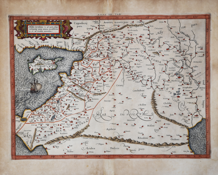
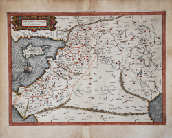
Map of the Holy Land, Cyprus, and Syria. Mercator recreated Ptolemy's conception of these regions while introducing the finesse and precision of his own cartographic style. The map features the regions as they were understood in the ancient world, with the Jordan River, Dead Sea, Mediterranean coast, and prominent cities like Jerusalem and Antioch clearly depicted. Similarly, the island of Cyprus, an important location in ancient Mediterranean trade routes, and Syria, the crossroads of several ancient civilizations, are also intricately detailed.
Taken from the Cl. Ptolemaei Alexandrini, Geographiae Libri Octo, first published in Cologne by Gottfried von Kempen (1578) and then reprinted by the same publisher in 1584 (Van der Krogt 1, 502) and then by Isaac Elsevier for the Petrus Bertius’ Theatrum Geographiae veteris (Leyden 1618).
Mercator's interpretation of the 28 Ptolemaic text was possibly one of the truest undertaken up until that time. He had spent 13 years researching, drawing and engraving the maps at much commercial sacrifice to himself, having seen Ortelius's Theatrum and De Jodes Speculum published, to become both technical and commercial successes. In later life he devoted himself to his edition of the maps in Ptolemy's Geographia, reproduced in his own engraving as nearly as possible in their original form.
This example comes from the Theatrum Geographia Veteris of Petrus Bertius published in Leiden in 1618, which combines Mercator's Ptolemy, the 8 plates of Moretus to represent the Tabula Peutingeriana and 14 historical maps of the regions of Europe derived from the Parergon of Ortelius.
Copperplate with fine later hand colour, in good condition.
|
Koeman Me 5; Nordenskiold 234; Phillips, P.L. (Atlases) 384; Shirley BL T.Ptol-11a & 11k; Van der Krogt, P. (Atlantes) 1:501.
|
Gerard MERCATOR (Kremer) (1512 - 1594)
|
For nearly sixty years, during the most important and exciting period in the story of modern map making, Gerard Mercator was the supreme cartographer, his name, second only to Ptolemy, synonymous with the form of map projection still in use today. Although not the inventor of this type of projection he was the first to apply it to navigational charts in such a form that compass bearings could be plotted on charts in straight lines, thereby providing seamen with a solution to an age-old problem of navigation at sea. His influence transformed land surveying and his researches and calculations led him to break away from Ptolemy's conception of the size and outline of the Continents, drastically reducing the longitudinal length of Europe and Asia and altering the shape of the Old World as visualized in the early sixteenth century.
Mercator was born in Rupelmonde in Flanders and studied in Louvain under Gemma Frisius, Dutch writer, astronomer and mathematician. He established himself there as a cartographer and instrument and globe maker, and when he was twenty-five drew and engraved his first map (of Palestine) and went on to produce a map of Flanders (1540) supervising the surveying and completing the drafting and engraving himself. The excellence of his work brought him the patronage of Charles V for whom he constructed a globe, but in spite of his favor with the Emperor he was caught up in the persecution of Lutheran protestants and charged with heresy, fortunately without serious consequences. No doubt the fear of further persecution influenced his move in 1552 to Duisburg, where he continued the production of maps, globes and instruments culminating in large-scale maps of Europe (1554), the British Isles (1564) and the famous World Map on 18 sheets drawn to his new projection (1569). All these early maps are exceedingly rare, some being known by only one copy.
In later life he devoted himself to his edition of the maps in Ptolemy's Geographia, reproduced in his own engraving as nearly as possible in their original form, and to the preparation of his 3-volume collection of maps to which, for the first time, the word 'Atlas' was applied. The word was chosen, he wrote, 'to honour the Titan, Atlas, King of Mauritania, a learned philosopher, mathematiciar, and astronomer' . The first two parts of the Atlas were published in 1585 and 1589 and the third, with the first two making a complete edition, in 1595 the year after Mercator's death.
Mercator's sons and grandsons, named above, were all cartographers and made their contributions in various ways to the great atlas. Rumold, in particular, was responsible for the complete edition in 1595. After a second complete edition in 1602, the map plates were bought in 1604 by Jodocus Hondius who, with his sons, Jodocus II and Henricus, published enlarged editions which dominated the map market for the following twenty to thirty years.
|
|
Koeman Me 5; Nordenskiold 234; Phillips, P.L. (Atlases) 384; Shirley BL T.Ptol-11a & 11k; Van der Krogt, P. (Atlantes) 1:501.
|
Gerard MERCATOR (Kremer) (1512 - 1594)
|
For nearly sixty years, during the most important and exciting period in the story of modern map making, Gerard Mercator was the supreme cartographer, his name, second only to Ptolemy, synonymous with the form of map projection still in use today. Although not the inventor of this type of projection he was the first to apply it to navigational charts in such a form that compass bearings could be plotted on charts in straight lines, thereby providing seamen with a solution to an age-old problem of navigation at sea. His influence transformed land surveying and his researches and calculations led him to break away from Ptolemy's conception of the size and outline of the Continents, drastically reducing the longitudinal length of Europe and Asia and altering the shape of the Old World as visualized in the early sixteenth century.
Mercator was born in Rupelmonde in Flanders and studied in Louvain under Gemma Frisius, Dutch writer, astronomer and mathematician. He established himself there as a cartographer and instrument and globe maker, and when he was twenty-five drew and engraved his first map (of Palestine) and went on to produce a map of Flanders (1540) supervising the surveying and completing the drafting and engraving himself. The excellence of his work brought him the patronage of Charles V for whom he constructed a globe, but in spite of his favor with the Emperor he was caught up in the persecution of Lutheran protestants and charged with heresy, fortunately without serious consequences. No doubt the fear of further persecution influenced his move in 1552 to Duisburg, where he continued the production of maps, globes and instruments culminating in large-scale maps of Europe (1554), the British Isles (1564) and the famous World Map on 18 sheets drawn to his new projection (1569). All these early maps are exceedingly rare, some being known by only one copy.
In later life he devoted himself to his edition of the maps in Ptolemy's Geographia, reproduced in his own engraving as nearly as possible in their original form, and to the preparation of his 3-volume collection of maps to which, for the first time, the word 'Atlas' was applied. The word was chosen, he wrote, 'to honour the Titan, Atlas, King of Mauritania, a learned philosopher, mathematiciar, and astronomer' . The first two parts of the Atlas were published in 1585 and 1589 and the third, with the first two making a complete edition, in 1595 the year after Mercator's death.
Mercator's sons and grandsons, named above, were all cartographers and made their contributions in various ways to the great atlas. Rumold, in particular, was responsible for the complete edition in 1595. After a second complete edition in 1602, the map plates were bought in 1604 by Jodocus Hondius who, with his sons, Jodocus II and Henricus, published enlarged editions which dominated the map market for the following twenty to thirty years.
|