| Reference: | S33905 |
| Author | David FUNCK |
| Year: | 1700 ca. |
| Zone: | The Holy Land |
| Printed: | Nurnberg |
| Measures: | 560 x 465 mm |
| Reference: | S33905 |
| Author | David FUNCK |
| Year: | 1700 ca. |
| Zone: | The Holy Land |
| Printed: | Nurnberg |
| Measures: | 560 x 465 mm |
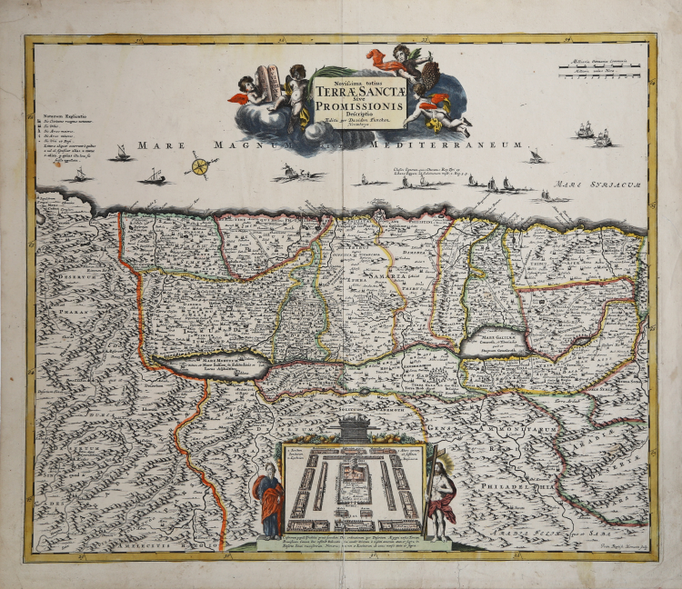
Engraved by J.B.Homann and published by David Funck. One of the very few maps engraved by Johan Baptist Homann, signed lower right. A rare map of the Holy Land, orientated with North at the right. With an inset showing the camp of the Israelites on their march through the desert.
An altogether stunning map of the Israel, Palestine, or the Holy Land. Issued in 1700 by David Funck of Nuremburg and geographically based upon Visscher's Map of 1659 and De Wit's Map of 1670. The shoreline runs from Sidon to Egypt along an East – West orientation. Divided according to the Tribes of Israel on both side of the River Jordan. Bottom center features a plan of the Temple of Solomon with the Ark of the Covenant featuring prominently. Moses and Jesus stand to either side of the plan.
Title cartouche appears at the top of the map and features four cherubs, one of which holds the Tablets of Moses or the Ten Commandments. In the Dead Sea (Mare Mortuum) the destroyed cities of Sodom, Gamora, Sebim and Adama are depicted. At sea, 14 ships sail the Mediterranean. All text is in Latin.
David Funck was an early to mid 18th century map publisher based in Nurenburg, Germany. He is known to have worked with such prominent cartographers as Homann and Doppelmayr. Funck also issued numerous maps independently.
Copperplate with fine original colour, very good condition.
|
Laor 296; Meurer/Stopp, Funck 1.15 mit Abb.; Sandler S. 57.
|
David FUNCK
|
Laor 296; Meurer/Stopp, Funck 1.15 mit Abb.; Sandler S. 57.
|
David FUNCK